![](/images/other/stat-length.png)
![Trail Walking Saint-Cirgues-la-Loutre - Le Gourdaloup 12 km - Saint Cirgues la Loutre - Pays de la Vallée de la Dordogne Corrézienne - Photo](https://media.geolcdn.com/t/1900/400/ext.pjpeg?maxdim=2&url=https%3A%2F%2Fservices.sitytrail.com%2FGeolivesWS%2FDownloadMedia.ashx%3FTrailID%3D112298%26Media%3D10305_1.jpg)
Le Gourdaloup 12 km - Saint Cirgues la Loutre - Pays de la Vallée de la Dordogne Corrézienne
tracegps
User
![Length](/images/other/stat-length.png)
![Max alt](https://static1.geolcdn.com/siteimages/upload/files/1508320355ic_sort_altitude_max_24dp.png)
![Uphill gradient](https://static1.geolcdn.com/siteimages/upload/files/1508320355ic_sort_den_pos_24dp.png)
![Km-Effort](/images/other/stat-length.png)
![Min alt](https://static1.geolcdn.com/siteimages/upload/files/1508320355ic_sort_altitude_min_24dp.png)
![Downhill gradient](https://static1.geolcdn.com/siteimages/upload/files/1508320355ic_sort_den_neg_24dp.png)
![Boucle](https://static1.geolcdn.com/siteimages/upload/files/16400158638029165_repeat_loop_refresh_sync_direction_icon.png)
![Walking](https://static1.geolcdn.com/sitytour/trail-icons/101.png)
3h00
Difficulty : Medium
![Scan this QR Code to open this trail in the SityTrail application](https://capi.geolives.com/qq0zvz2zws4bq2lad0pu/sitytour/trails/112298/qr.png?size=200)
FREE GPS app for hiking
About
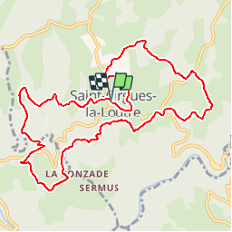
Trail Walking of 11.9 km to be discovered at New Aquitaine, Corrèze, Saint-Cirgues-la-Loutre. This trail is proposed by tracegps.
Description
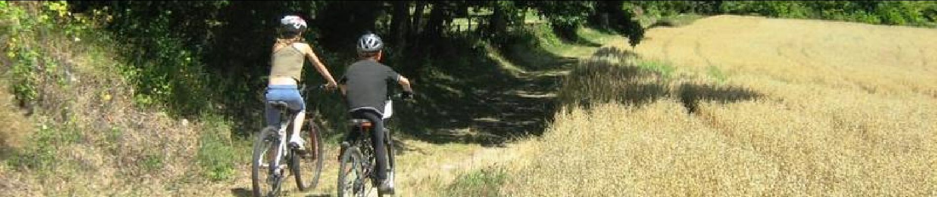
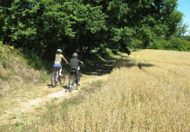
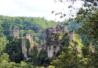
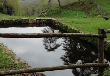
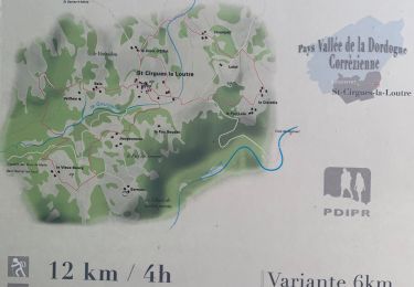
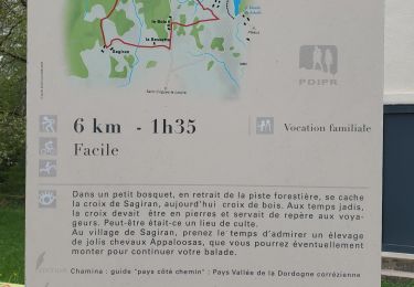
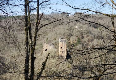
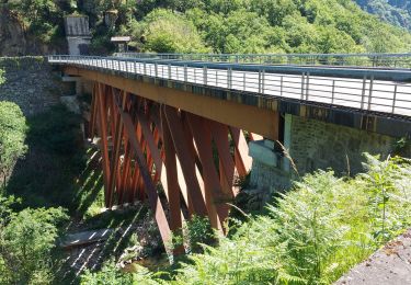
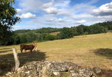
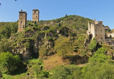
Le Gourdaloup 12 km - Saint Cirgues la Loutre - Pays de la Vallée de la Dordogne Corrézienne. Au cœur de la Xaintrie Blanche, ce long circuit, qui peut être réduit de moitié alterne des petites routes et des chemins faciles, très roulant à V.T.T. Multipliant les points de vue sur le ruisseau du Gourdaloup, les gorges de la Maronne, le bourg de SAINT-CIRGUES-LA-LOUTRE (son église et sa légende), les tours de Carbonnières, les Tours de Merle, le Château du Rieu, il traverse le vieux bourg de Saint Geniez ô Merle. En traversant les villages vous remarquerez les maisons de Xaintrie, des puits, une source, un four à pain Téléchargez la fiche du circuit sur le site du Conseil Général de la Corrèze. Renseignements : Mairie de St Cirgues la Loutre 05.55.28.27.04
Positioning
Comments
Trails nearby
![Trail Walking Saint-Cirgues-la-Loutre - Le Gourdaloup 6 km - Saint Cirgues la Loutre - Pays de la Vallée de la Dordogne Corrézienne - Photo](https://media.geolcdn.com/t/375/260/ext.jpg?maxdim=2&url=https%3A%2F%2Fservices.sitytrail.com%2FGeolivesWS%2FDownloadMedia.ashx%3FTrailID%3D112330%26Media%3D10360_1.jpg)
![Walking Walking](https://static1.geolcdn.com/sitytour/trail-icons/101.png)
Walking
![](/images/other/stat-length.png)
![](https://static1.geolcdn.com/siteimages/upload/files/16400158638029165_repeat_loop_refresh_sync_direction_icon.png)
![Trail Walking Saint-Cirgues-la-Loutre - Les Tours de Merlé - Saint Cirgues la Loutre - Photo](https://media.geolcdn.com/t/375/260/ext.jpg?maxdim=2&url=https%3A%2F%2Fservices.sitytrail.com%2FGeolivesWS%2FDownloadMedia.ashx%3FTrailID%3D106306%26Media%3D10691_1.jpg)
![Walking Walking](https://static1.geolcdn.com/sitytour/trail-icons/101.png)
Walking
![](/images/other/stat-length.png)
![](https://static1.geolcdn.com/siteimages/upload/files/16400158638029165_repeat_loop_refresh_sync_direction_icon.png)
![Trail Walking Goulles - Fred BC GOULLES - Photo](https://media.geolcdn.com/t/375/260/ext.jpg?maxdim=2&url=https%3A%2F%2Fmedia.geolcdn.com%2Ff%2Fe8141b16-10db-4c81-af02-a30b2efafbbf.jpg)
![Walking Walking](https://static1.geolcdn.com/sitytour/trail-icons/101.png)
Walking
![](/images/other/stat-length.png)
![](https://static1.geolcdn.com/siteimages/upload/files/16400158638029165_repeat_loop_refresh_sync_direction_icon.png)
![Trail Walking Saint-Cirgues-la-Loutre - le Gourdaloup - Photo](https://media.geolcdn.com/t/375/260/ext.jpg?maxdim=2&url=https%3A%2F%2Fmedia.geolcdn.com%2Ff%2F32c17a79-c1ba-4c25-a7e6-d0d33eb021a6.jpg)
![Walking Walking](https://static1.geolcdn.com/sitytour/trail-icons/101.png)
Walking
![](/images/other/stat-length.png)
![](https://static1.geolcdn.com/siteimages/upload/files/16400158638029165_repeat_loop_refresh_sync_direction_icon.png)
![Trail Walking Saint-Julien-aux-Bois - Croix de Sagiran - Photo](https://media.geolcdn.com/t/375/260/ext.jpg?maxdim=2&url=https%3A%2F%2Fmedia.geolcdn.com%2Ff%2F1a371f0d-5b0a-4f26-a8f1-d42b6e1251d5.jpg)
![Walking Walking](https://static1.geolcdn.com/sitytour/trail-icons/101.png)
Walking
![](/images/other/stat-length.png)
![](https://static1.geolcdn.com/siteimages/upload/files/16400158638029165_repeat_loop_refresh_sync_direction_icon.png)
![Trail Walking Goulles - Les tours Carbonnieres - Photo](https://media.geolcdn.com/t/375/260/ext.jpg?maxdim=2&url=https%3A%2F%2Fmedia.geolcdn.com%2Ff%2F90a7e5fb-b218-42bd-a403-ae58cfbb4d41.jpg)
![Walking Walking](https://static1.geolcdn.com/sitytour/trail-icons/101.png)
Walking
![](/images/other/stat-length.png)
![](https://static1.geolcdn.com/siteimages/upload/files/16400158638029165_repeat_loop_refresh_sync_direction_icon.png)
![Trail Walking Saint-Geniez-ô-Merle - 20210615 Tours de Merle - Photo](https://media.geolcdn.com/t/375/260/ext.jpg?maxdim=2&url=https%3A%2F%2Fmedia.geolcdn.com%2Ff%2F6024fabf-7fcc-4d15-853b-ddcf0aa5120e.jpg)
![Walking Walking](https://static1.geolcdn.com/sitytour/trail-icons/101.png)
Walking
![](/images/other/stat-length.png)
![](https://static1.geolcdn.com/siteimages/upload/files/16400158638029165_repeat_loop_refresh_sync_direction_icon.png)
![Trail Walking Saint-Privat - Malesse - tours de Merle - Photo](https://media.geolcdn.com/t/375/260/ext.jpg?maxdim=2&url=https%3A%2F%2Fmedia.geolcdn.com%2Ff%2Fcf29b99a-6a16-4068-860b-c6da043e231f.jpg)
![Walking Walking](https://static1.geolcdn.com/sitytour/trail-icons/101.png)
Walking
![](/images/other/stat-length.png)
![](https://static1.geolcdn.com/siteimages/upload/files/16400158638029165_repeat_loop_refresh_sync_direction_icon.png)
![Trail Walking Saint-Geniez-ô-Merle - Les tours de Merle - Photo](https://media.geolcdn.com/t/375/260/ext.jpg?maxdim=2&url=https%3A%2F%2Fservices.sitytrail.com%2FGeolivesWS%2FDownloadMedia.ashx%3FTrailID%3D705307%26Media%3D9368312f-2f0c-4c6e-b94a-95b4492775b0.JPG)
![Walking Walking](https://static1.geolcdn.com/sitytour/trail-icons/101.png)
Walking
![](/images/other/stat-length.png)
![](https://static1.geolcdn.com/siteimages/upload/files/16400158638029165_repeat_loop_refresh_sync_direction_icon.png)