Trail Walking Martizay - Circuit Est de Martizay - Photo

Circuit Est de Martizay

 tracegps
tracegps

User

© OpenStreetMap contributors
Length
Length
15.8 km
Max alt
Max alt
98 m
Uphill gradient
Uphill gradient
105 m
Km-Effort
Km-Effort  
17.2 km
Min alt
Min alt
75 m
Downhill gradient
Downhill gradient
105 m
Boucle
Boucle
Yes
Creation date :
2014-12-10 00:00:00.0
Updated on :
2014-12-10 00:00:00.0

(0 Reviews)

Walking
Walking
3h55
Difficulty : Difficult

Scan this QR Code to open this trail in the SityTrail application

FREE GPS app for hiking

Logo SityTrail SityTrail

IGN / Geographical institutes

Download SityTrail from the App Store Download SityTrail from Google Play

Logo SityTrail SityTrail World

The world is yours!

Download SityTrail from the App Store Download SityTrail from Google Play Download SityTrail on Huawei AppGallery

About

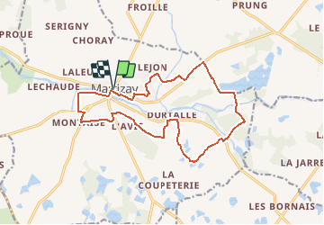
Trail Walking of 15.8 km to be discovered at Centre-Loire Valley, Indre, Martizay. This trail is proposed by tracegps.

Description

"Les Marcheux d'la Claise" et la mairie de Martizay vous invitent à venir découvrir les environs de Martizay. Départ de l’église de Martizay. Retrouvez le circuit sur le site de la Mairie de martizay.

Elevation profile

Photos

Positioning

Country:
France
Region :
Centre-Loire Valley
Department/Province :
Indre
Municipality :
Martizay
Location:
Unknown
Start:(UTM)
350679 ; 5185533 (31T) N.

Trails nearby

Trail Walking Martizay - Circuit Ouest de Martizay - Photo
Walking
tracegps

Walking

Difficult
Martizay, Centre-Loire Valley, Indre, France
12.6 km | 14 km-effort
3h 10min
Yes
Trail Walking Martizay - Circuit Nord de Martizay - Photo
Walking
tracegps

Walking

Easy
Martizay, Centre-Loire Valley, Indre, France
6.7 km | 7.4 km-effort
1h 40min
Yes
Trail Walking Azay-le-Ferron - Azay le ferron  - Photo
Walking
Dupuybadonniere

Walking

Very easy
Azay-le-Ferron, Centre-Loire Valley, Indre, France
9.4 km | 10.6 km-effort
2h 38min
Yes


Close
My subscriptions