![](/images/other/stat-length.png)
![Trail Walking Lentillères - Crêtes et hameaux de Lentillières - Photo](https://media.geolcdn.com/t/1900/400/ext.pjpeg?maxdim=2&url=https%3A%2F%2Fstatic1.geolcdn.com%2Fsiteimages%2Fupload%2Ffiles%2F1553511878bg_sport_marche.png)
Crêtes et hameaux de Lentillières
nfranche
User
![Length](/images/other/stat-length.png)
Length
11.3 km
![Max alt](https://static1.geolcdn.com/siteimages/upload/files/1508320355ic_sort_altitude_max_24dp.png)
Max alt
765 m
![Uphill gradient](https://static1.geolcdn.com/siteimages/upload/files/1508320355ic_sort_den_pos_24dp.png)
Uphill gradient
485 m
![Km-Effort](/images/other/stat-length.png)
Km-Effort
17.8 km
![Min alt](https://static1.geolcdn.com/siteimages/upload/files/1508320355ic_sort_altitude_min_24dp.png)
Min alt
442 m
![Downhill gradient](https://static1.geolcdn.com/siteimages/upload/files/1508320355ic_sort_den_neg_24dp.png)
Downhill gradient
484 m
![Boucle](https://static1.geolcdn.com/siteimages/upload/files/16400158638029165_repeat_loop_refresh_sync_direction_icon.png)
Boucle
Yes
Creation date :
2019-05-06 17:37:29.976
Updated on :
2019-05-06 17:37:29.976
![Walking](https://static1.geolcdn.com/sitytour/trail-icons/101.png)
3h40
Difficulty : Medium
![Scan this QR Code to open this trail in the SityTrail application](https://capi.geolives.com/qq0zvz2zws4bq2lad0pu/sitytour/trails/1122385/qr.png?size=200)
FREE GPS app for hiking
About
Trail Walking of 11.3 km to be discovered at Auvergne-Rhône-Alpes, Ardèche, Lentillères. This trail is proposed by nfranche.
Description
Rando qui nous fait monter sur une crête d'où l'on découvre un panorama exceptionnel sur le plateau ardéchois, le bassin d'Aubenas et le Vercors.
Points of interest
Positioning
Country:
France
Region :
Auvergne-Rhône-Alpes
Department/Province :
Ardèche
Municipality :
Lentillères
Location:
Unknown
Start:(Dec)
Start:(UTM)
604191 ; 4940918 (31T) N.
Comments
Trails nearby
![Trail Walking Jaujac - Jaujac Le Ventapet 14km - Photo](https://media.geolcdn.com/t/375/260/6a0eb2eb-cf2c-4f85-a155-e7f0aba82db8.jpg&format=jpg&maxdim=2)
![Walking Walking](https://static1.geolcdn.com/sitytour/trail-icons/101.png)
Jaujac Le Ventapet 14km
Walking
Very difficult
(1)
Jaujac,
Auvergne-Rhône-Alpes,
Ardèche,
France
![](/images/other/stat-length.png)
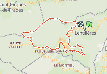
13.6 km | 23 km-effort
5h 18min
![](https://static1.geolcdn.com/siteimages/upload/files/16400158638029165_repeat_loop_refresh_sync_direction_icon.png)
Yes
![Trail Walking Lentillères - Lentillières_les cretes_les Hameaux-13-02-17 - Photo](https://media.geolcdn.com/t/375/260/b26fd82a-80a8-4147-8d0f-0d41ac6326b3.jpg&format=jpg&maxdim=2)
![Walking Walking](https://static1.geolcdn.com/sitytour/trail-icons/101.png)
Lentillières_les cretes_les Hameaux-13-02-17
Walking
Very easy
(1)
Lentillères,
Auvergne-Rhône-Alpes,
Ardèche,
France
![](/images/other/stat-length.png)
12.2 km | 18.7 km-effort
3h 58min
![](https://static1.geolcdn.com/siteimages/upload/files/16400158638029165_repeat_loop_refresh_sync_direction_icon.png)
Yes
![Trail Walking Fabras - Fabras - Photo](https://media.geolcdn.com/t/375/260/ext.jpg?maxdim=2&url=https%3A%2F%2Fstatic1.geolcdn.com%2Fsiteimages%2Fupload%2Ffiles%2F1553511878bg_sport_marche.png)
![Walking Walking](https://static1.geolcdn.com/sitytour/trail-icons/101.png)
Fabras
Walking
Medium
(1)
Fabras,
Auvergne-Rhône-Alpes,
Ardèche,
France
![](/images/other/stat-length.png)
6.4 km | 9.7 km-effort
1h 49min
![](https://static1.geolcdn.com/siteimages/upload/files/16400158638029165_repeat_loop_refresh_sync_direction_icon.png)
No
![Trail Walking Jaujac - 07 jaujac rocher de l aigle - Photo](https://media.geolcdn.com/t/375/260/1a765c03-1770-4ba1-9c9c-9314823e934b.jpg&format=jpg&maxdim=2)
![Walking Walking](https://static1.geolcdn.com/sitytour/trail-icons/101.png)
07 jaujac rocher de l aigle
Walking
Easy
(1)
Jaujac,
Auvergne-Rhône-Alpes,
Ardèche,
France
![](/images/other/stat-length.png)
11.2 km | 19.7 km-effort
6h 23min
![](https://static1.geolcdn.com/siteimages/upload/files/16400158638029165_repeat_loop_refresh_sync_direction_icon.png)
Yes
![Walking Walking](https://static1.geolcdn.com/sitytour/trail-icons/101.png)
2024-09-25_21h25m23_Ailhon 9km
Walking
Medium
Ailhon,
Auvergne-Rhône-Alpes,
Ardèche,
France
![](/images/other/stat-length.png)
8.3 km | 11.7 km-effort
2h 39min
![](https://static1.geolcdn.com/siteimages/upload/files/16400158638029165_repeat_loop_refresh_sync_direction_icon.png)
Yes
![Trail Walking Jaujac - ARDECHE, JAUJAC. .PONT DE L ECHELLE O - Photo](https://media.geolcdn.com/t/375/260/306eb66a-9a51-42c8-b3b4-a2c469fe7bd7.jpg&format=jpg&maxdim=2)
![Walking Walking](https://static1.geolcdn.com/sitytour/trail-icons/101.png)
ARDECHE, JAUJAC. .PONT DE L ECHELLE O
Walking
Medium
Jaujac,
Auvergne-Rhône-Alpes,
Ardèche,
France
![](/images/other/stat-length.png)
5.1 km | 8.3 km-effort
2h 33min
![](https://static1.geolcdn.com/siteimages/upload/files/16400158638029165_repeat_loop_refresh_sync_direction_icon.png)
No
![Trail Walking Jaujac - 07_jaujac_Orgues_9km360m - Photo](https://media.geolcdn.com/t/375/260/944ad327-537f-4f2c-8001-5010f7cb1f7d.jpg&format=jpg&maxdim=2)
![Walking Walking](https://static1.geolcdn.com/sitytour/trail-icons/101.png)
07_jaujac_Orgues_9km360m
Walking
Medium
Jaujac,
Auvergne-Rhône-Alpes,
Ardèche,
France
![](/images/other/stat-length.png)
9.1 km | 13.8 km-effort
3h 7min
![](https://static1.geolcdn.com/siteimages/upload/files/16400158638029165_repeat_loop_refresh_sync_direction_icon.png)
Yes
![Trail Walking Fabras - Fabras Jaujac les orgues basaltiques - Photo](https://media.geolcdn.com/t/375/260/427a2c6b-ef91-4b91-a4d9-6a96b4534007.jpg&format=jpg&maxdim=2)
![Walking Walking](https://static1.geolcdn.com/sitytour/trail-icons/101.png)
Fabras Jaujac les orgues basaltiques
Walking
Very difficult
Fabras,
Auvergne-Rhône-Alpes,
Ardèche,
France
![](/images/other/stat-length.png)
14.9 km | 22 km-effort
5h 17min
![](https://static1.geolcdn.com/siteimages/upload/files/16400158638029165_repeat_loop_refresh_sync_direction_icon.png)
Yes
![Walking Walking](https://static1.geolcdn.com/sitytour/trail-icons/101.png)
2023-03-20_16h29m52_Chazeaux 9km.GPX.xml
Walking
Difficult
Chazeaux,
Auvergne-Rhône-Alpes,
Ardèche,
France
![](/images/other/stat-length.png)
8.3 km | 13.4 km-effort
3h 0min
![](https://static1.geolcdn.com/siteimages/upload/files/16400158638029165_repeat_loop_refresh_sync_direction_icon.png)
Yes