![](/images/other/stat-length.png)
![Trail Walking Alleyrat - Mystérieuses Fontaines 12 km - Alleyrat - Pays de Haute Corrèze - Photo](https://media.geolcdn.com/t/1900/400/ext.pjpeg?maxdim=2&url=https%3A%2F%2Fservices.sitytrail.com%2FGeolivesWS%2FDownloadMedia.ashx%3FTrailID%3D112211%26Media%3D10103_1.jpg)
Mystérieuses Fontaines 12 km - Alleyrat - Pays de Haute Corrèze
tracegps
User
![Length](/images/other/stat-length.png)
![Max alt](https://static1.geolcdn.com/siteimages/upload/files/1508320355ic_sort_altitude_max_24dp.png)
![Uphill gradient](https://static1.geolcdn.com/siteimages/upload/files/1508320355ic_sort_den_pos_24dp.png)
![Km-Effort](/images/other/stat-length.png)
![Min alt](https://static1.geolcdn.com/siteimages/upload/files/1508320355ic_sort_altitude_min_24dp.png)
![Downhill gradient](https://static1.geolcdn.com/siteimages/upload/files/1508320355ic_sort_den_neg_24dp.png)
![Boucle](https://static1.geolcdn.com/siteimages/upload/files/16400158638029165_repeat_loop_refresh_sync_direction_icon.png)
![Walking](https://static1.geolcdn.com/sitytour/trail-icons/101.png)
3h00
Difficulty : Medium
![Scan this QR Code to open this trail in the SityTrail application](https://capi.geolives.com/qq0zvz2zws4bq2lad0pu/sitytour/trails/112211/qr.png?size=200)
FREE GPS app for hiking
About
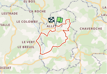
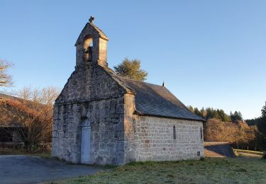
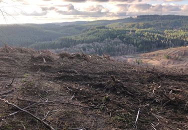
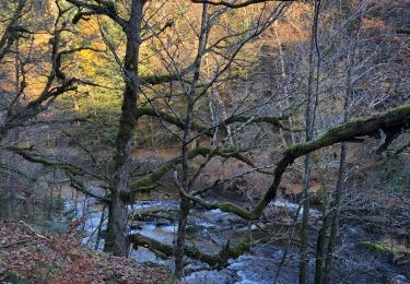
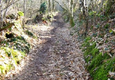
Trail Walking of 12.1 km to be discovered at New Aquitaine, Corrèze, Alleyrat. This trail is proposed by tracegps.
Description
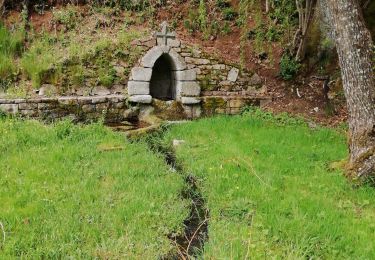
Mystérieuses Fontaines - Alleyrat 12 km - Pays de Haute Corrèze Quand votre oreille perçoit la douce mélodie de l’eau, approchez vous, écoutez-la vous conter ses secrets et laissez voguer votre imagination… Empruntez ce sentier à la découverte de ces mystérieuses sources et fontaines, des lavoirs, des puits et des moulins. Découvrez toutes ces architectures construites pour collecter et exploiter cet élément indispensable à la vie : l’eau ! Téléchargez la fiche du circuit sur le site du Conseil Général de la Corrèze. Renseignements : Office de Tourisme de Meymac ; 05.55.95.18.43
Positioning
Comments
Trails nearby
![Trail Walking Saint-Germain-Lavolps - Fred st Germain lavolps - Photo](https://media.geolcdn.com/t/375/260/7283a6ee-c42f-4dba-a358-1661a243c229.jpg&format=jpg&maxdim=2)
![Walking Walking](https://static1.geolcdn.com/sitytour/trail-icons/101.png)
Walking
![](/images/other/stat-length.png)
![](https://static1.geolcdn.com/siteimages/upload/files/16400158638029165_repeat_loop_refresh_sync_direction_icon.png)
![Trail Walking Meymac - Lestrade-La Vialle-Le Colomby - Photo](https://media.geolcdn.com/t/375/260/5ddeede1-0c7c-48f5-820b-c121b8dba3c5.jpg&format=jpg&maxdim=2)
![Walking Walking](https://static1.geolcdn.com/sitytour/trail-icons/101.png)
Walking
![](/images/other/stat-length.png)
![](https://static1.geolcdn.com/siteimages/upload/files/16400158638029165_repeat_loop_refresh_sync_direction_icon.png)
![Trail sport Chaveroche - F 2024 Chaveroche - Photo](https://media.geolcdn.com/t/375/260/cd9aec4d-d52e-44c9-a47c-785720becf03.jpg&format=jpg&maxdim=2)
sport
![](/images/other/stat-length.png)
![](https://static1.geolcdn.com/siteimages/upload/files/16400158638029165_repeat_loop_refresh_sync_direction_icon.png)
![Trail Walking Saint-Pardoux-le-Vieux - la gare de Saint-pardoux-le-vieux - Photo](https://media.geolcdn.com/t/375/260/b80863fe-befd-4f22-9b78-ff74f08aeb11.jpg&format=jpg&maxdim=2)
![Walking Walking](https://static1.geolcdn.com/sitytour/trail-icons/101.png)
Walking
![](/images/other/stat-length.png)
![](https://static1.geolcdn.com/siteimages/upload/files/16400158638029165_repeat_loop_refresh_sync_direction_icon.png)
![Trail Walking Meymac - Puy Baubière - Photo](https://media.geolcdn.com/t/375/260/f59ac1de-9b24-4d1e-8cc0-af55a58e4d5d.jpeg&format=jpg&maxdim=2)
![Walking Walking](https://static1.geolcdn.com/sitytour/trail-icons/101.png)
Walking
![](/images/other/stat-length.png)
![](https://static1.geolcdn.com/siteimages/upload/files/16400158638029165_repeat_loop_refresh_sync_direction_icon.png)
![Trail Walking Chaveroche - Le Chassaing - Photo](https://media.geolcdn.com/t/375/260/8254810a-8ccc-41fa-91ed-f29c7ffaf766.jpeg&format=jpg&maxdim=2)
![Walking Walking](https://static1.geolcdn.com/sitytour/trail-icons/101.png)
![Trail Walking Alleyrat - Alleyrat Corrèze - Photo](https://media.geolcdn.com/t/375/260/ext.jpg?maxdim=2&url=https%3A%2F%2Fservices.sitytrail.com%2FGeolivesWS%2FDownloadMedia.ashx%3FTrailID%3D610334%26Media%3D20160807161431.jpg)
![Walking Walking](https://static1.geolcdn.com/sitytour/trail-icons/101.png)
Walking
![](/images/other/stat-length.png)
![](https://static1.geolcdn.com/siteimages/upload/files/16400158638029165_repeat_loop_refresh_sync_direction_icon.png)
![Trail Walking Saint-Pardoux-le-Vieux - Chemins de traverse 5km - Saint Pardoux le Vieux - Pays de Haute Corrèze - Photo](https://media.geolcdn.com/t/375/260/ext.jpg?maxdim=2&url=https%3A%2F%2Fservices.sitytrail.com%2FGeolivesWS%2FDownloadMedia.ashx%3FTrailID%3D112480%26Media%3D10653_1.jpg)
![Walking Walking](https://static1.geolcdn.com/sitytour/trail-icons/101.png)
Walking
![](/images/other/stat-length.png)
![](https://static1.geolcdn.com/siteimages/upload/files/16400158638029165_repeat_loop_refresh_sync_direction_icon.png)
![Trail Mountain bike Saint-Pardoux-le-Vieux - Chemins de traverse 10km - Saint Pardoux le Vieux - Pays de Haute Corrèze - Photo](https://media.geolcdn.com/t/375/260/ext.jpg?maxdim=2&url=https%3A%2F%2Fservices.sitytrail.com%2FGeolivesWS%2FDownloadMedia.ashx%3FTrailID%3D112428%26Media%3D10539_1.jpg)
![Mountain bike Mountain bike](https://static1.geolcdn.com/sitytour/trail-icons/202.png)
Mountain bike
![](/images/other/stat-length.png)
![](https://static1.geolcdn.com/siteimages/upload/files/16400158638029165_repeat_loop_refresh_sync_direction_icon.png)