![](/images/other/stat-length.png)
![Trail Walking Murs - Joucas Grotte Bérigoule - Photo](https://media.geolcdn.com/t/1900/400/ext.pjpeg?maxdim=2&url=https%3A%2F%2Fstatic1.geolcdn.com%2Fsiteimages%2Fupload%2Ffiles%2F1553511878bg_sport_marche.png)
Joucas Grotte Bérigoule
momo305649
User
![Length](/images/other/stat-length.png)
Length
55 km
![Max alt](https://static1.geolcdn.com/siteimages/upload/files/1508320355ic_sort_altitude_max_24dp.png)
Max alt
635 m
![Uphill gradient](https://static1.geolcdn.com/siteimages/upload/files/1508320355ic_sort_den_pos_24dp.png)
Uphill gradient
1372 m
![Km-Effort](/images/other/stat-length.png)
Km-Effort
74 km
![Min alt](https://static1.geolcdn.com/siteimages/upload/files/1508320355ic_sort_altitude_min_24dp.png)
Min alt
264 m
![Downhill gradient](https://static1.geolcdn.com/siteimages/upload/files/1508320355ic_sort_den_neg_24dp.png)
Downhill gradient
1610 m
![Boucle](https://static1.geolcdn.com/siteimages/upload/files/16400158638029165_repeat_loop_refresh_sync_direction_icon.png)
Boucle
No
Creation date :
2019-05-06 17:32:24.325
Updated on :
2019-05-06 17:32:24.325
![Walking](https://static1.geolcdn.com/sitytour/trail-icons/101.png)
5m
Difficulty : Difficult
![Scan this QR Code to open this trail in the SityTrail application](https://capi.geolives.com/qq0zvz2zws4bq2lad0pu/sitytour/trails/1122037/qr.png?size=200)
FREE GPS app for hiking
About
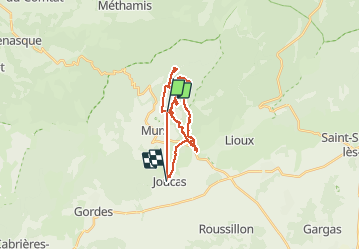
Trail Walking of 55 km to be discovered at Provence-Alpes-Côte d'Azur, Vaucluse, Murs. This trail is proposed by momo305649.
Description
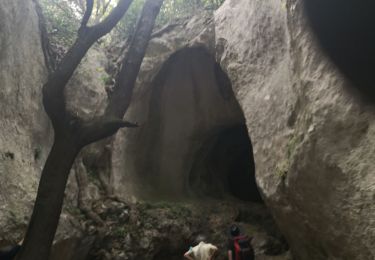
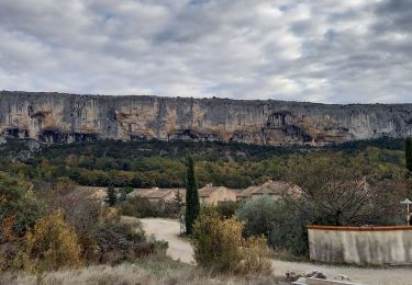
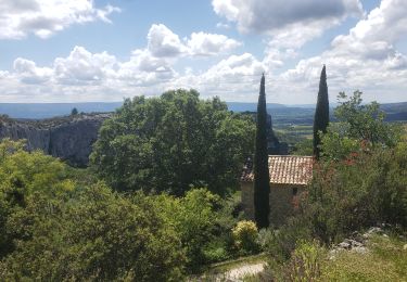
Depuis Joucas ,on traverse la superbe Combe de Vaumale ,puis l'on continue vers la Grotte de Bérigoule ,descente sentier tour du Vaucluse
Positioning
Country:
France
Region :
Provence-Alpes-Côte d'Azur
Department/Province :
Vaucluse
Municipality :
Murs
Location:
Unknown
Start:(Dec)
Start:(UTM)
680609 ; 4869984 (31T) N.
Comments
Trails nearby
![Trail Walking Murs - les grottes de Bérigoule - Photo](https://media.geolcdn.com/t/375/260/ce8aee04-002d-4e83-9fcd-7eaa425f944d.jpg&format=jpg&maxdim=2)
![Walking Walking](https://static1.geolcdn.com/sitytour/trail-icons/101.png)
les grottes de Bérigoule
Walking
Medium
(1)
Murs,
Provence-Alpes-Côte d'Azur,
Vaucluse,
France
![](/images/other/stat-length.png)
8.6 km | 11.9 km-effort
4h 57min
![](https://static1.geolcdn.com/siteimages/upload/files/16400158638029165_repeat_loop_refresh_sync_direction_icon.png)
No
![Trail Walking Lioux - VAUCLUSE Lioux Vaumalle - Photo](https://media.geolcdn.com/t/375/260/ext.jpg?maxdim=2&url=https%3A%2F%2Fstatic1.geolcdn.com%2Fsiteimages%2Fupload%2Ffiles%2F1553511878bg_sport_marche.png)
![Walking Walking](https://static1.geolcdn.com/sitytour/trail-icons/101.png)
VAUCLUSE Lioux Vaumalle
Walking
Medium
(1)
Lioux,
Provence-Alpes-Côte d'Azur,
Vaucluse,
France
![](/images/other/stat-length.png)
14.1 km | 19.1 km-effort
7h 17min
![](https://static1.geolcdn.com/siteimages/upload/files/16400158638029165_repeat_loop_refresh_sync_direction_icon.png)
Yes
![Trail Walking Lioux - Combes de Vaumale et Lioux - Photo](https://media.geolcdn.com/t/375/260/99475262-f86b-4ddd-a204-2ec68a62c7f4.jpg&format=jpg&maxdim=2)
![Walking Walking](https://static1.geolcdn.com/sitytour/trail-icons/101.png)
Combes de Vaumale et Lioux
Walking
Difficult
Lioux,
Provence-Alpes-Côte d'Azur,
Vaucluse,
France
![](/images/other/stat-length.png)
14.5 km | 19.8 km-effort
4h 26min
![](https://static1.geolcdn.com/siteimages/upload/files/16400158638029165_repeat_loop_refresh_sync_direction_icon.png)
Yes
![Walking Walking](https://static1.geolcdn.com/sitytour/trail-icons/101.png)
PF-Murs - Véroncle, un ravin et des moulins
Walking
Medium
Murs,
Provence-Alpes-Côte d'Azur,
Vaucluse,
France
![](/images/other/stat-length.png)
7.1 km | 9.1 km-effort
2h 4min
![](https://static1.geolcdn.com/siteimages/upload/files/16400158638029165_repeat_loop_refresh_sync_direction_icon.png)
Yes
![Mountain bike Mountain bike](https://static1.geolcdn.com/sitytour/trail-icons/202.png)
activity_9127223965
Mountain bike
Very difficult
Gordes,
Provence-Alpes-Côte d'Azur,
Vaucluse,
France
![](/images/other/stat-length.png)
35 km | 49 km-effort
3h 22min
![](https://static1.geolcdn.com/siteimages/upload/files/16400158638029165_repeat_loop_refresh_sync_direction_icon.png)
Yes
![Mountain bike Mountain bike](https://static1.geolcdn.com/sitytour/trail-icons/202.png)
Gordes_20210913_100058
Mountain bike
Very easy
Gordes,
Provence-Alpes-Côte d'Azur,
Vaucluse,
France
![](/images/other/stat-length.png)
20 km | 27 km-effort
Unknown
![](https://static1.geolcdn.com/siteimages/upload/files/16400158638029165_repeat_loop_refresh_sync_direction_icon.png)
Yes
![On foot On foot](https://static1.geolcdn.com/sitytour/trail-icons/100.png)
Gordes 10 km
On foot
Difficult
Gordes,
Provence-Alpes-Côte d'Azur,
Vaucluse,
France
![](/images/other/stat-length.png)
9.2 km | 13 km-effort
Unknown
![](https://static1.geolcdn.com/siteimages/upload/files/16400158638029165_repeat_loop_refresh_sync_direction_icon.png)
No
![Trail Walking Lioux - 134-Gorges de Vaumale et gorges de Lioux - Photo](https://media.geolcdn.com/t/375/260/ext.jpg?maxdim=2&url=https%3A%2F%2Fstatic1.geolcdn.com%2Fsiteimages%2Fupload%2Ffiles%2F1553511878bg_sport_marche.png)
![Walking Walking](https://static1.geolcdn.com/sitytour/trail-icons/101.png)
134-Gorges de Vaumale et gorges de Lioux
Walking
Medium
(2)
Lioux,
Provence-Alpes-Côte d'Azur,
Vaucluse,
France
![](/images/other/stat-length.png)
13.9 km | 18.9 km-effort
3h 24min
![](https://static1.geolcdn.com/siteimages/upload/files/16400158638029165_repeat_loop_refresh_sync_direction_icon.png)
Yes
![Trail Walking Lioux - Falaise de la madeleine - Photo](https://media.geolcdn.com/t/375/260/4554fd54-5b3e-4364-b0b2-30b77f21eda5.jpg&format=jpg&maxdim=2)
![Walking Walking](https://static1.geolcdn.com/sitytour/trail-icons/101.png)
Falaise de la madeleine
Walking
Medium
Lioux,
Provence-Alpes-Côte d'Azur,
Vaucluse,
France
![](/images/other/stat-length.png)
6.8 km | 10.4 km-effort
2h 21min
![](https://static1.geolcdn.com/siteimages/upload/files/16400158638029165_repeat_loop_refresh_sync_direction_icon.png)
Yes