![](/images/other/stat-length.png)
![Trail Cycle Vacherauville - Verdun Champ de Bataille - Vacherauville - Photo](https://media.geolcdn.com/t/1900/400/ext.pjpeg?maxdim=2&url=https%3A%2F%2Fservices.sitytrail.com%2FGeolivesWS%2FDownloadMedia.ashx%3FTrailID%3D112040%26Media%3D9568_5.jpg)
Verdun Champ de Bataille - Vacherauville
tracegps
User
![Length](/images/other/stat-length.png)
Length
54 km
![Max alt](https://static1.geolcdn.com/siteimages/upload/files/1508320355ic_sort_altitude_max_24dp.png)
Max alt
386 m
![Uphill gradient](https://static1.geolcdn.com/siteimages/upload/files/1508320355ic_sort_den_pos_24dp.png)
Uphill gradient
747 m
![Km-Effort](/images/other/stat-length.png)
Km-Effort
64 km
![Min alt](https://static1.geolcdn.com/siteimages/upload/files/1508320355ic_sort_altitude_min_24dp.png)
Min alt
188 m
![Downhill gradient](https://static1.geolcdn.com/siteimages/upload/files/1508320355ic_sort_den_neg_24dp.png)
Downhill gradient
747 m
![Boucle](https://static1.geolcdn.com/siteimages/upload/files/16400158638029165_repeat_loop_refresh_sync_direction_icon.png)
Boucle
Yes
Creation date :
2014-12-10 00:00:00.0
Updated on :
2014-12-10 00:00:00.0
![Cycle](https://static1.geolcdn.com/sitytour/trail-icons/200.png)
3h00
Difficulty : Medium
![Scan this QR Code to open this trail in the SityTrail application](https://capi.geolives.com/qq0zvz2zws4bq2lad0pu/sitytour/trails/112040/qr.png?size=200)
FREE GPS app for hiking
About
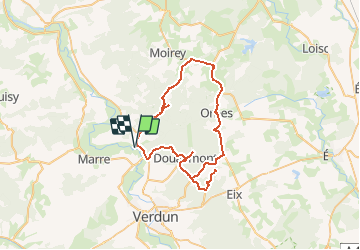
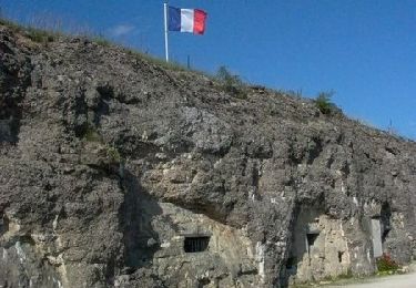
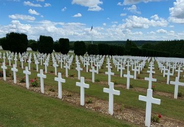
Trail Cycle of 54 km to be discovered at Grand Est, Meuse, Vacherauville. This trail is proposed by tracegps.
Description
Circuit proposé par le Comité Départemental du Tourisme de la Meuse. Départ de l’église de Vacherauville. Retrouvez ce circuit sur le site du Comité Départemental du Tourisme de la Meuse.
Positioning
Country:
France
Region :
Grand Est
Department/Province :
Meuse
Municipality :
Vacherauville
Location:
Unknown
Start:(Dec)
Start:(UTM)
671792 ; 5454732 (31U) N.
Comments
Trails nearby
![Trail Other activity Charny-sur-Meuse - La Meuse de Charny sur Meuse à Regnéville - Photo](https://media.geolcdn.com/t/375/260/ext.jpg?maxdim=2&url=https%3A%2F%2Fservices.sitytrail.com%2FGeolivesWS%2FDownloadMedia.ashx%3FTrailID%3D316891%26Media%3D15978_4.jpg)
![Other activity Other activity](https://static1.geolcdn.com/sitytour/trail-icons/900.png)
La Meuse de Charny sur Meuse à Regnéville
Other activity
Medium
Charny-sur-Meuse,
Grand Est,
Meuse,
France
![](/images/other/stat-length.png)
15 km | 16.2 km-effort
2h 30min
![](https://static1.geolcdn.com/siteimages/upload/files/16400158638029165_repeat_loop_refresh_sync_direction_icon.png)
No
![Trail Walking Fleury-devant-Douaumont - douaumont - Photo](https://media.geolcdn.com/t/375/260/ext.jpg?maxdim=2&url=https%3A%2F%2Fservices.sitytrail.com%2FGeolivesWS%2FDownloadMedia.ashx%3FTrailID%3D162298%26Media%3D20121111124635.jpeg)
![Walking Walking](https://static1.geolcdn.com/sitytour/trail-icons/101.png)
douaumont
Walking
Easy
Fleury-devant-Douaumont,
Grand Est,
Meuse,
France
![](/images/other/stat-length.png)
13.5 km | 16 km-effort
3h 41min
![](https://static1.geolcdn.com/siteimages/upload/files/16400158638029165_repeat_loop_refresh_sync_direction_icon.png)
Yes
![Trail Cycle Bras-sur-Meuse - Villages détruits de la Bataille de Verdun - Bras-sur-Meuse - Photo](https://media.geolcdn.com/t/375/260/ext.jpg?maxdim=2&url=https%3A%2F%2Fservices.sitytrail.com%2FGeolivesWS%2FDownloadMedia.ashx%3FTrailID%3D111940%26Media%3D9081_6.jpg)
![Cycle Cycle](https://static1.geolcdn.com/sitytour/trail-icons/200.png)
Villages détruits de la Bataille de Verdun - Bras-sur-Meuse
Cycle
Medium
Bras-sur-Meuse,
Grand Est,
Meuse,
France
![](/images/other/stat-length.png)
37 km | 45 km-effort
2h 0min
![](https://static1.geolcdn.com/siteimages/upload/files/16400158638029165_repeat_loop_refresh_sync_direction_icon.png)
Yes
![Trail Electric bike Charny-sur-Meuse - Tour de Verdun - Photo](https://media.geolcdn.com/t/375/260/ad3d1d68-bbf1-4181-a2c4-138e4ba1f84a.jpg&format=jpg&maxdim=2)
![Electric bike Electric bike](https://static1.geolcdn.com/sitytour/trail-icons/205.png)
Tour de Verdun
Electric bike
Easy
Charny-sur-Meuse,
Grand Est,
Meuse,
France
![](/images/other/stat-length.png)
41 km | 48 km-effort
6h 36min
![](https://static1.geolcdn.com/siteimages/upload/files/16400158638029165_repeat_loop_refresh_sync_direction_icon.png)
Yes
![Trail Walking Douaumont-Vaux - La route des hommes 2020 - Photo](https://media.geolcdn.com/t/375/260/e8a69eae-8476-4617-ad89-b7c044c8a997.jpg&format=jpg&maxdim=2)
![Walking Walking](https://static1.geolcdn.com/sitytour/trail-icons/101.png)
La route des hommes 2020
Walking
Difficult
Douaumont-Vaux,
Grand Est,
Meuse,
France
![](/images/other/stat-length.png)
50 km | 65 km-effort
9h 5min
![](https://static1.geolcdn.com/siteimages/upload/files/16400158638029165_repeat_loop_refresh_sync_direction_icon.png)
Yes
![Trail Mountain bike Thierville-sur-Meuse - Verdun centre - Photo](https://media.geolcdn.com/t/375/260/ext.jpg?maxdim=2&url=https%3A%2F%2Fstatic1.geolcdn.com%2Fsiteimages%2Fupload%2Ffiles%2F1524743154velo.jpg)
![Mountain bike Mountain bike](https://static1.geolcdn.com/sitytour/trail-icons/202.png)
Verdun centre
Mountain bike
Very easy
Thierville-sur-Meuse,
Grand Est,
Meuse,
France
![](/images/other/stat-length.png)
26 km | 29 km-effort
3h 6min
![](https://static1.geolcdn.com/siteimages/upload/files/16400158638029165_repeat_loop_refresh_sync_direction_icon.png)
Yes
![Trail Mountain bike Belleville-sur-Meuse - sortie ASPTT 1 - Photo](https://media.geolcdn.com/t/375/260/ext.jpg?maxdim=2&url=https%3A%2F%2Fstatic1.geolcdn.com%2Fsiteimages%2Fupload%2Ffiles%2F1524743154velo.jpg)
![Mountain bike Mountain bike](https://static1.geolcdn.com/sitytour/trail-icons/202.png)
sortie ASPTT 1
Mountain bike
Medium
Belleville-sur-Meuse,
Grand Est,
Meuse,
France
![](/images/other/stat-length.png)
41 km | 48 km-effort
3h 54min
![](https://static1.geolcdn.com/siteimages/upload/files/16400158638029165_repeat_loop_refresh_sync_direction_icon.png)
No
![Trail Walking Belleville-sur-Meuse - Randonnée AEP - samedi 23 février - Photo](https://media.geolcdn.com/t/375/260/ext.jpg?maxdim=2&url=https%3A%2F%2Fstatic1.geolcdn.com%2Fsiteimages%2Fupload%2Ffiles%2F1553511878bg_sport_marche.png)
![Walking Walking](https://static1.geolcdn.com/sitytour/trail-icons/101.png)
Randonnée AEP - samedi 23 février
Walking
Very easy
Belleville-sur-Meuse,
Grand Est,
Meuse,
France
![](/images/other/stat-length.png)
11.2 km | 12.7 km-effort
2h 20min
![](https://static1.geolcdn.com/siteimages/upload/files/16400158638029165_repeat_loop_refresh_sync_direction_icon.png)
No
![Trail Mountain bike Belleville-sur-Meuse - sortie VTT ASPTT Verdun - Photo](https://media.geolcdn.com/t/375/260/ext.jpg?maxdim=2&url=https%3A%2F%2Fstatic1.geolcdn.com%2Fsiteimages%2Fupload%2Ffiles%2F1524743154velo.jpg)
![Mountain bike Mountain bike](https://static1.geolcdn.com/sitytour/trail-icons/202.png)
sortie VTT ASPTT Verdun
Mountain bike
Very easy
Belleville-sur-Meuse,
Grand Est,
Meuse,
France
![](/images/other/stat-length.png)
15.2 km | 18.2 km-effort
1h 47min
![](https://static1.geolcdn.com/siteimages/upload/files/16400158638029165_repeat_loop_refresh_sync_direction_icon.png)
Yes