![](/images/other/stat-length.png)
![Trail Walking Oderen - Le Trehkopf par le Uhufels et le Gommkopf - Photo](https://media.geolcdn.com/t/1900/400/ext.pjpeg?maxdim=2&url=https%3A%2F%2Fservices.sitytrail.com%2FGeolivesWS%2FDownloadMedia.ashx%3FTrailID%3D111991%26Media%3D9400_6.jpg)
Le Trehkopf par le Uhufels et le Gommkopf
tracegps
User
![Length](/images/other/stat-length.png)
![Max alt](https://static1.geolcdn.com/siteimages/upload/files/1508320355ic_sort_altitude_max_24dp.png)
![Uphill gradient](https://static1.geolcdn.com/siteimages/upload/files/1508320355ic_sort_den_pos_24dp.png)
![Km-Effort](/images/other/stat-length.png)
![Min alt](https://static1.geolcdn.com/siteimages/upload/files/1508320355ic_sort_altitude_min_24dp.png)
![Downhill gradient](https://static1.geolcdn.com/siteimages/upload/files/1508320355ic_sort_den_neg_24dp.png)
![Boucle](https://static1.geolcdn.com/siteimages/upload/files/16400158638029165_repeat_loop_refresh_sync_direction_icon.png)
![Walking](https://static1.geolcdn.com/sitytour/trail-icons/101.png)
4h30
Difficulty : Difficult
![Scan this QR Code to open this trail in the SityTrail application](https://capi.geolives.com/qq0zvz2zws4bq2lad0pu/sitytour/trails/111991/qr.png?size=200)
FREE GPS app for hiking
About
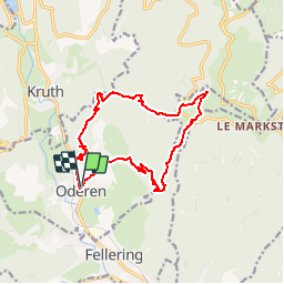
Trail Walking of 13.8 km to be discovered at Grand Est, Haut-Rhin, Oderen. This trail is proposed by tracegps.
Description
Le Trehkopf est le lieu des Vosges de tous les amoureux de montagne et de sports de montagne! Tout y est! Que ce soit pour randonner, skier (alpin, rando, fond), faire du parapente, du kite, du deltaplane...etc. Le Treh est le point de rassemblement de tous les sentiers en provenance de la vallée de la Thur et ouvrant la voie vers tous les sommets les plus hauts et les plus réputés des Vosges! Accolé au Markstein, il se situe environ à mi chemin entre le Grand-Ballon et le Hohneck en suivant la route des crêtes. Dans l'une des plus belles vallées des Vosges, beau parcours très varié alternant les belvédères rocheux, les sentiers en forêt et les vues dégagées. Fort dénivelé de 830 mètres (sommet à 1266m) mais toujours progressif et sans fortes pentes. D'abord le rocher de la Chouette ( Uhufels ) promontoire rocher permettant une vue plongeante sur la vallée et les sommets du Ventron et Drumont . Le sommet du Gommkopf coiffé de son tilleul solitaire porte la vue bien loin sur l'Alsace et une vision panoramique sur les crêtes qui dominent la vallée. Plus haut, le Trehkopf et ses plate-forme d'envol en delta-plane .Au sommet du Markstein c'est une vue très étendue sur la plupart des grands sommets des Vosges. Descente en forêt sur de beaux sentiers ombragés et peu fréquentés, par le Schalm sauvage. Départ : Mairie d’Oderen (rue de Durrenbach – parking) Balisage : triangle bleu – triangle jaune – triangle rouge – drapelet rouge blanc rouge – disque jaune – disque bleu.
Points of interest
Positioning
Comments
Trails nearby
![Trail Walking Kruth - Autour du lac de Kruth-Wildenstein - Photo](https://media.geolcdn.com/t/375/260/c1e79833-f011-4190-a625-acd1b44dc0b0.jpeg&format=jpg&maxdim=2)
![Walking Walking](https://static1.geolcdn.com/sitytour/trail-icons/101.png)
Walking
![](/images/other/stat-length.png)
![](https://static1.geolcdn.com/siteimages/upload/files/16400158638029165_repeat_loop_refresh_sync_direction_icon.png)
![Trail Walking Fellering - Felsach _chapelle ST Nicolas_frenz - Photo](https://media.geolcdn.com/t/375/260/ext.jpg?maxdim=2&url=https%3A%2F%2Fstatic1.geolcdn.com%2Fsiteimages%2Fupload%2Ffiles%2F1553511878bg_sport_marche.png)
![Walking Walking](https://static1.geolcdn.com/sitytour/trail-icons/101.png)
Walking
![](/images/other/stat-length.png)
![](https://static1.geolcdn.com/siteimages/upload/files/16400158638029165_repeat_loop_refresh_sync_direction_icon.png)
![Trail Walking Oderen - 6146369-Chapelle St Nicolas 2 - Photo](https://media.geolcdn.com/t/375/260/ext.jpg?maxdim=2&url=https%3A%2F%2Fstatic1.geolcdn.com%2Fsiteimages%2Fupload%2Ffiles%2F1553511878bg_sport_marche.png)
![Walking Walking](https://static1.geolcdn.com/sitytour/trail-icons/101.png)
Walking
![](/images/other/stat-length.png)
![](https://static1.geolcdn.com/siteimages/upload/files/16400158638029165_repeat_loop_refresh_sync_direction_icon.png)
![Trail Walking Kruth - barrage de Wildenstein et Grand Ventron - Photo](https://media.geolcdn.com/t/375/260/ext.jpg?maxdim=2&url=https%3A%2F%2Fservices.sitytrail.com%2FGeolivesWS%2FDownloadMedia.ashx%3FTrailID%3D491500%26Media%3Dfix__20151107153447.jpg)
![Walking Walking](https://static1.geolcdn.com/sitytour/trail-icons/101.png)
Walking
![](/images/other/stat-length.png)
![](https://static1.geolcdn.com/siteimages/upload/files/16400158638029165_repeat_loop_refresh_sync_direction_icon.png)
![Trail Mountain bike Metzeral - Breitfirst - Petit Ballon - Col de Firstplan - Wintzenheim - Photo](https://media.geolcdn.com/t/375/260/ext.jpg?maxdim=2&url=https%3A%2F%2Fstatic1.geolcdn.com%2Fsiteimages%2Fupload%2Ffiles%2F1524743154velo.jpg)
![Mountain bike Mountain bike](https://static1.geolcdn.com/sitytour/trail-icons/202.png)
Mountain bike
![](/images/other/stat-length.png)
![](https://static1.geolcdn.com/siteimages/upload/files/16400158638029165_repeat_loop_refresh_sync_direction_icon.png)
![Trail Walking Kruth - le grand Ve tron - Photo](https://media.geolcdn.com/t/375/260/f2c4ef7b-d5ea-4350-b113-528ee63bd3d3.jpg&format=jpg&maxdim=2)
![Walking Walking](https://static1.geolcdn.com/sitytour/trail-icons/101.png)
Walking
![](/images/other/stat-length.png)
![](https://static1.geolcdn.com/siteimages/upload/files/16400158638029165_repeat_loop_refresh_sync_direction_icon.png)
![Trail Walking Oderen - TREK ALSACIEN (boucle, la meute) - Photo](https://media.geolcdn.com/t/375/260/bce13479-4ed1-47a7-a848-8fc9fefb1457.jpg&format=jpg&maxdim=2)
![Walking Walking](https://static1.geolcdn.com/sitytour/trail-icons/101.png)
Walking
![](/images/other/stat-length.png)
![](https://static1.geolcdn.com/siteimages/upload/files/16400158638029165_repeat_loop_refresh_sync_direction_icon.png)
![Trail Walking Oderen - Oderen Bergenbach Langenbach - Photo](https://media.geolcdn.com/t/375/260/05163254-f106-4300-b7bd-e85eb3e624ac.jpg&format=jpg&maxdim=2)
![Walking Walking](https://static1.geolcdn.com/sitytour/trail-icons/101.png)
Walking
![](/images/other/stat-length.png)
![](https://static1.geolcdn.com/siteimages/upload/files/16400158638029165_repeat_loop_refresh_sync_direction_icon.png)
![Trail Walking Oderen - TREK ALSACIEN (1ère étape) - Photo](https://media.geolcdn.com/t/375/260/787fe892-71a8-4daf-8eb0-6ad69c3ebb22.jpg&format=jpg&maxdim=2)
![Walking Walking](https://static1.geolcdn.com/sitytour/trail-icons/101.png)
Walking
![](/images/other/stat-length.png)
![](https://static1.geolcdn.com/siteimages/upload/files/16400158638029165_repeat_loop_refresh_sync_direction_icon.png)