Trail Walking Le Castéra - Chemin de La Hire - Le Castera - Photo

Chemin de La Hire - Le Castera

 tracegps
tracegps

User

© OpenStreetMap contributors
Length
Length
9.6 km
Max alt
Max alt
258 m
Uphill gradient
Uphill gradient
242 m
Km-Effort
Km-Effort  
12.8 km
Min alt
Min alt
131 m
Downhill gradient
Downhill gradient
245 m
Boucle
Boucle
Yes
Creation date :
2014-12-10 00:00:00.0
Updated on :
2014-12-10 00:00:00.0

(1 Reviews)

Walking
Walking
2h45
Difficulty : Medium

Scan this QR Code to open this trail in the SityTrail application

FREE GPS app for hiking

Logo SityTrail SityTrail

IGN / Geographical institutes

Download SityTrail from the App Store Download SityTrail from Google Play

Logo SityTrail SityTrail World

The world is yours!

Download SityTrail from the App Store Download SityTrail from Google Play Download SityTrail on Huawei AppGallery

About

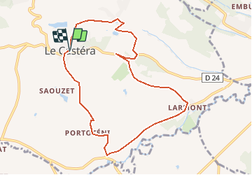
Trail Walking of 9.6 km to be discovered at Occitania, Haute-Garonne, Le Castéra. This trail is proposed by tracegps.

Description

Chemin de La Hire – Le Castera Des plaines de Save en bosquets, de vallons en collines, venez découvrir les terres de La Hire. Etiennes de Vignolles, dit La Hire était le Seigneur du Castéra et de Pradère en 1426. C’est aussi le Valet de Cœur des jeux de cartes. Les circuits de la Communauté de Communes du Canton de Cadours sont accessibles aux randonneurs pédestres, équestres et VTT. Les temps de parcours sont indiqués à pied. Renseignements au Syndicat d’Initiative du Canton de Cadours, Bibliothèque Cantonale local n°2, 18 rue de la Mairie, 31480 Cadours – Tel 05.62.13.74.00 – email syndicadours (at) orange.fr

Elevation profile

Photos

Positioning

Country:
France
Region :
Occitania
Department/Province :
Haute-Garonne
Municipality :
Le Castéra
Location:
Unknown
Start:(UTM)
350008 ; 4837134 (31T) N.

Comments

Please log in to post a review or rate the element


Trails nearby

Trail Running Menville - Crêtes salées - Photo
Running
tracegps

Running

Difficult
Menville, Occitania, Haute-Garonne, France
13.9 km | 17.9 km-effort
1h 30min
Yes
Trail Mountain bike Menville - Crêtes salées - Photo
Mountain bike
tracegps

Mountain bike

Easy
Menville, Occitania, Haute-Garonne, France
13.9 km | 17.9 km-effort
1h 0min
Yes
Trail Walking Menville - Crêtes salées - Photo
Walking
tracegps

Walking

Medium
Menville, Occitania, Haute-Garonne, France
13.9 km | 17.9 km-effort
2h 49min
Yes
Trail Walking Lasserre-Pradère - LASSERE-PRADERE rando nocturne  - Photo
Walking
chrisgps

Walking

Medium
Lasserre-Pradère, Occitania, Haute-Garonne, France
8 km | 9.6 km-effort
2h 11min
Yes
Trail Running Mérenvielle - De Mérenvielle à la forêt de Bouconne - Photo
Running
tracegps

Running

Very difficult
Mérenvielle, Occitania, Haute-Garonne, France
20 km | 25 km-effort
2h 0min
Yes
Trail Walking Mérenvielle - De Mérenvielle à la forêt de Bouconne - Photo
Walking
tracegps

Walking

Difficult
Mérenvielle, Occitania, Haute-Garonne, France
20 km | 25 km-effort
4h 0min
Yes
Trail Running Lévignac - ForestTrail-2015-Supernova - Photo
Running
Polo-31

Running

Difficult
Lévignac, Occitania, Haute-Garonne, France
41 km | 54 km-effort
6h 0min
Yes
Trail Mountain bike Lasserre-Pradère - Rando des chataignes  - Photo
Mountain bike
stefdurougier

Mountain bike

Very easy
Lasserre-Pradère, Occitania, Haute-Garonne, France
33 km | 38 km-effort
2h 23min
Yes
Trail Mountain bike Lasserre-Pradère - Lasserre - Leguevin (Place du marché) - Photo
Mountain bike
Mamicharge

Mountain bike

Easy
Lasserre-Pradère, Occitania, Haute-Garonne, France
8.6 km | 10.2 km-effort
Unknown
No


Close
My subscriptions