![](/images/other/stat-length.png)
![Trail Mountain bike Peyruis - Base VTT FFCT Val de Durance - Les Iscles - Circuit n°9 - Peyruis - Photo](https://media.geolcdn.com/t/1900/400/ext.pjpeg?maxdim=2&url=https%3A%2F%2Fservices.sitytrail.com%2FGeolivesWS%2FDownloadMedia.ashx%3FTrailID%3D111898%26Media%3D8893_1.jpg)
Base VTT FFCT Val de Durance - Les Iscles - Circuit n°9 - Peyruis
tracegps
User
![Length](/images/other/stat-length.png)
Length
8.6 km
![Max alt](https://static1.geolcdn.com/siteimages/upload/files/1508320355ic_sort_altitude_max_24dp.png)
Max alt
410 m
![Uphill gradient](https://static1.geolcdn.com/siteimages/upload/files/1508320355ic_sort_den_pos_24dp.png)
Uphill gradient
52 m
![Km-Effort](/images/other/stat-length.png)
Km-Effort
9.3 km
![Min alt](https://static1.geolcdn.com/siteimages/upload/files/1508320355ic_sort_altitude_min_24dp.png)
Min alt
380 m
![Downhill gradient](https://static1.geolcdn.com/siteimages/upload/files/1508320355ic_sort_den_neg_24dp.png)
Downhill gradient
54 m
![Boucle](https://static1.geolcdn.com/siteimages/upload/files/16400158638029165_repeat_loop_refresh_sync_direction_icon.png)
Boucle
Yes
Creation date :
2014-12-10 00:00:00.0
Updated on :
2014-12-10 00:00:00.0
![Mountain bike](https://static1.geolcdn.com/sitytour/trail-icons/202.png)
1h00
Difficulty : Easy
![Scan this QR Code to open this trail in the SityTrail application](https://capi.geolives.com/qq0zvz2zws4bq2lad0pu/sitytour/trails/111898/qr.png?size=200)
FREE GPS app for hiking
About
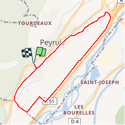
Trail Mountain bike of 8.6 km to be discovered at Provence-Alpes-Côte d'Azur, Alpes-de-Haute-Provence, Peyruis. This trail is proposed by tracegps.
Description
Les Iscles est un circuit familial, une première sortie pour se dérouiller les jambes. 9 km, 30m de dénivelé, 1h.
Positioning
Country:
France
Region :
Provence-Alpes-Côte d'Azur
Department/Province :
Alpes-de-Haute-Provence
Municipality :
Peyruis
Location:
Unknown
Start:(Dec)
Start:(UTM)
735192 ; 4878811 (31T) N.
Comments
Trails nearby
![Trail Walking Ganagobie - GANAGOBIE . Tour par le bas . Visite Ganagobie o m s - Photo](https://media.geolcdn.com/t/375/260/f43abf33-22fe-4846-8dac-9d35176e3e78.jpg&format=jpg&maxdim=2)
![Walking Walking](https://static1.geolcdn.com/sitytour/trail-icons/101.png)
GANAGOBIE . Tour par le bas . Visite Ganagobie o m s
Walking
Medium
(1)
Ganagobie,
Provence-Alpes-Côte d'Azur,
Alpes-de-Haute-Provence,
France
![](/images/other/stat-length.png)
14.6 km | 21 km-effort
3h 55min
![](https://static1.geolcdn.com/siteimages/upload/files/16400158638029165_repeat_loop_refresh_sync_direction_icon.png)
Yes
![Trail Walking Montfort - MONTFORT. Voie Royale . Chapelle saint Donat . Trou de l Hermite o .t - Photo](https://media.geolcdn.com/t/375/260/d6bdfeb5-13cc-49a1-ada4-32ae5dc71202.jpg&format=jpg&maxdim=2)
![Walking Walking](https://static1.geolcdn.com/sitytour/trail-icons/101.png)
MONTFORT. Voie Royale . Chapelle saint Donat . Trou de l Hermite o .t
Walking
Medium
(1)
Montfort,
Provence-Alpes-Côte d'Azur,
Alpes-de-Haute-Provence,
France
![](/images/other/stat-length.png)
11.8 km | 15.3 km-effort
2h 59min
![](https://static1.geolcdn.com/siteimages/upload/files/16400158638029165_repeat_loop_refresh_sync_direction_icon.png)
No
![Trail Walking Château-Arnoux-Saint-Auban - SAINT AUBAN . SENTIER DE DÉCOUVERTE DE L AÉRODROME O L - Photo](https://media.geolcdn.com/t/375/260/5308a4ad-7d11-40e8-b20c-9444363024fd.jpg&format=jpg&maxdim=2)
![Walking Walking](https://static1.geolcdn.com/sitytour/trail-icons/101.png)
SAINT AUBAN . SENTIER DE DÉCOUVERTE DE L AÉRODROME O L
Walking
Medium
(1)
Château-Arnoux-Saint-Auban,
Provence-Alpes-Côte d'Azur,
Alpes-de-Haute-Provence,
France
![](/images/other/stat-length.png)
6.5 km | 7.6 km-effort
1h 40min
![](https://static1.geolcdn.com/siteimages/upload/files/16400158638029165_repeat_loop_refresh_sync_direction_icon.png)
Yes
![Trail Walking Les Mées - Les Mées - Malijai - Les Mées - Photo](https://media.geolcdn.com/t/375/260/ext.jpg?maxdim=2&url=https%3A%2F%2Fservices.sitytrail.com%2FGeolivesWS%2FDownloadMedia.ashx%3FTrailID%3D107386%26Media%3D12288_6.jpg)
![Walking Walking](https://static1.geolcdn.com/sitytour/trail-icons/101.png)
Les Mées - Malijai - Les Mées
Walking
Medium
(1)
Les Mées,
Provence-Alpes-Côte d'Azur,
Alpes-de-Haute-Provence,
France
![](/images/other/stat-length.png)
12.1 km | 18.1 km-effort
4h 30min
![](https://static1.geolcdn.com/siteimages/upload/files/16400158638029165_repeat_loop_refresh_sync_direction_icon.png)
Yes
![Trail Walking Les Mées - Les Pénitents - circuit long - Les Mées - Photo](https://media.geolcdn.com/t/375/260/ext.jpg?maxdim=2&url=https%3A%2F%2Fservices.sitytrail.com%2FGeolivesWS%2FDownloadMedia.ashx%3FTrailID%3D107187%26Media%3D12039_6.jpg)
![Walking Walking](https://static1.geolcdn.com/sitytour/trail-icons/101.png)
Les Pénitents - circuit long - Les Mées
Walking
Medium
(1)
Les Mées,
Provence-Alpes-Côte d'Azur,
Alpes-de-Haute-Provence,
France
![](/images/other/stat-length.png)
14.3 km | 21 km-effort
4h 0min
![](https://static1.geolcdn.com/siteimages/upload/files/16400158638029165_repeat_loop_refresh_sync_direction_icon.png)
Yes
![Trail Walking Les Mées - Les Pénitents - circuit court - Les Mées - Photo](https://media.geolcdn.com/t/375/260/ext.jpg?maxdim=2&url=https%3A%2F%2Fservices.sitytrail.com%2FGeolivesWS%2FDownloadMedia.ashx%3FTrailID%3D107038%26Media%3D11843_5.jpg)
![Walking Walking](https://static1.geolcdn.com/sitytour/trail-icons/101.png)
Les Pénitents - circuit court - Les Mées
Walking
Medium
(2)
Les Mées,
Provence-Alpes-Côte d'Azur,
Alpes-de-Haute-Provence,
France
![](/images/other/stat-length.png)
5.8 km | 9.5 km-effort
2h 0min
![](https://static1.geolcdn.com/siteimages/upload/files/16400158638029165_repeat_loop_refresh_sync_direction_icon.png)
Yes
![Trail Walking Ganagobie - Plateau de Ganagobie - Photo](https://media.geolcdn.com/t/375/260/ext.jpg?maxdim=2&url=https%3A%2F%2Fservices.sitytrail.com%2FGeolivesWS%2FDownloadMedia.ashx%3FTrailID%3D107037%26Media%3D11842_5.jpg)
![Walking Walking](https://static1.geolcdn.com/sitytour/trail-icons/101.png)
Plateau de Ganagobie
Walking
Medium
(2)
Ganagobie,
Provence-Alpes-Côte d'Azur,
Alpes-de-Haute-Provence,
France
![](/images/other/stat-length.png)
7.6 km | 10.9 km-effort
3h 0min
![](https://static1.geolcdn.com/siteimages/upload/files/16400158638029165_repeat_loop_refresh_sync_direction_icon.png)
Yes
![Trail Other activity Les Mées - MEES Penitents. San Peyre. Panneaux Volcanique. Saint Antoine - Photo](https://media.geolcdn.com/t/375/260/ext.jpg?maxdim=2&url=https%3A%2F%2Fstatic1.geolcdn.com%2Fsiteimages%2Fupload%2Ffiles%2F1545311037marcheuse_200dpi.jpg)
![Other activity Other activity](https://static1.geolcdn.com/sitytour/trail-icons/900.png)
MEES Penitents. San Peyre. Panneaux Volcanique. Saint Antoine
Other activity
Very easy
(1)
Les Mées,
Provence-Alpes-Côte d'Azur,
Alpes-de-Haute-Provence,
France
![](/images/other/stat-length.png)
14.7 km | 22 km-effort
5h 47min
![](https://static1.geolcdn.com/siteimages/upload/files/16400158638029165_repeat_loop_refresh_sync_direction_icon.png)
Yes
![Trail Walking Les Mées - 2023-04-14 Les Apollinaires- Haute montagne - Les Pénitents - Photo](https://media.geolcdn.com/t/375/260/f3a0c66a-8d90-4fe7-a5a0-7a5aeb543308.jpg&format=jpg&maxdim=2)
![Walking Walking](https://static1.geolcdn.com/sitytour/trail-icons/101.png)
2023-04-14 Les Apollinaires- Haute montagne - Les Pénitents
Walking
Medium
Les Mées,
Provence-Alpes-Côte d'Azur,
Alpes-de-Haute-Provence,
France
![](/images/other/stat-length.png)
17.5 km | 26 km-effort
5h 49min
![](https://static1.geolcdn.com/siteimages/upload/files/16400158638029165_repeat_loop_refresh_sync_direction_icon.png)
Yes