![](/images/other/stat-length.png)
![Trail Walking Saussines - Les capitelles de la Bénovie à Saussines - Photo](https://media.geolcdn.com/t/1900/400/ext.pjpeg?maxdim=2&url=https%3A%2F%2Fservices.sitytrail.com%2FGeolivesWS%2FDownloadMedia.ashx%3FTrailID%3D111889%26Media%3D8862_2.jpg)
Les capitelles de la Bénovie à Saussines
tracegps
User
![Length](/images/other/stat-length.png)
Length
9.3 km
![Max alt](https://static1.geolcdn.com/siteimages/upload/files/1508320355ic_sort_altitude_max_24dp.png)
Max alt
66 m
![Uphill gradient](https://static1.geolcdn.com/siteimages/upload/files/1508320355ic_sort_den_pos_24dp.png)
Uphill gradient
96 m
![Km-Effort](/images/other/stat-length.png)
Km-Effort
10.5 km
![Min alt](https://static1.geolcdn.com/siteimages/upload/files/1508320355ic_sort_altitude_min_24dp.png)
Min alt
29 m
![Downhill gradient](https://static1.geolcdn.com/siteimages/upload/files/1508320355ic_sort_den_neg_24dp.png)
Downhill gradient
97 m
![Boucle](https://static1.geolcdn.com/siteimages/upload/files/16400158638029165_repeat_loop_refresh_sync_direction_icon.png)
Boucle
Yes
Creation date :
2014-12-10 00:00:00.0
Updated on :
2014-12-10 00:00:00.0
![Walking](https://static1.geolcdn.com/sitytour/trail-icons/101.png)
2h30
Difficulty : Medium
![Scan this QR Code to open this trail in the SityTrail application](https://capi.geolives.com/qq0zvz2zws4bq2lad0pu/sitytour/trails/111889/qr.png?size=200)
FREE GPS app for hiking
About
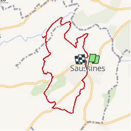
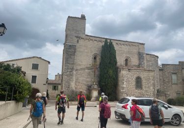
Trail Walking of 9.3 km to be discovered at Occitania, Hérault, Saussines. This trail is proposed by tracegps.
Description
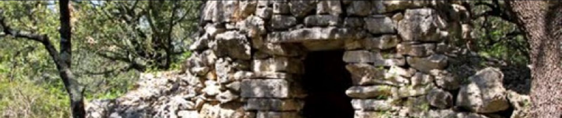
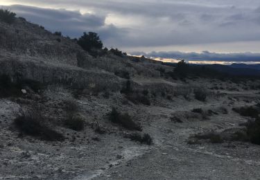
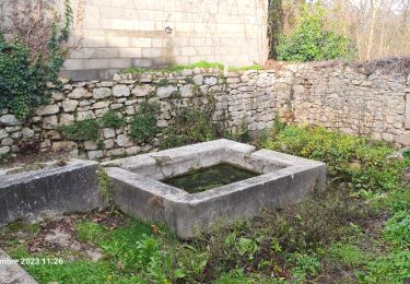
Les capitelles de la Bénovie à Saussines. 10 km pour les amateurs de randonnées, au cœur de la garrigue Saussinoise, à la découverte d’abris en pierres sèches, lavoir, drailles... Télécharger la fiche rando.
Positioning
Country:
France
Region :
Occitania
Department/Province :
Hérault
Municipality :
Saussines
Location:
Unknown
Start:(Dec)
Start:(UTM)
585057 ; 4845998 (31T) N.
Comments
Trails nearby
![Trail Walking Sommières - SOMMIERES 30 - VILLEVIEILLE châteaux- JUNAS les carrières - Photo](https://media.geolcdn.com/t/375/260/ext.jpg?maxdim=2&url=https%3A%2F%2Fservices.sitytrail.com%2FGeolivesWS%2FDownloadMedia.ashx%3FTrailID%3D421587%26Media%3D20150516132041.jpg)
![Walking Walking](https://static1.geolcdn.com/sitytour/trail-icons/101.png)
SOMMIERES 30 - VILLEVIEILLE châteaux- JUNAS les carrières
Walking
Medium
(2)
Sommières,
Occitania,
Gard,
France
![](/images/other/stat-length.png)
14 km | 16.9 km-effort
2h 34min
![](https://static1.geolcdn.com/siteimages/upload/files/16400158638029165_repeat_loop_refresh_sync_direction_icon.png)
Yes
![Trail Walking Saussines - Saussines - Photo](https://media.geolcdn.com/t/375/260/ext.jpg?maxdim=2&url=https%3A%2F%2Fstatic1.geolcdn.com%2Fsiteimages%2Fupload%2Ffiles%2F1553511878bg_sport_marche.png)
![Walking Walking](https://static1.geolcdn.com/sitytour/trail-icons/101.png)
Saussines
Walking
Very easy
(1)
Saussines,
Occitania,
Hérault,
France
![](/images/other/stat-length.png)
13.3 km | 14.9 km-effort
4h 13min
![](https://static1.geolcdn.com/siteimages/upload/files/16400158638029165_repeat_loop_refresh_sync_direction_icon.png)
Yes
![Trail Walking Sommières - Autour de Villevielle 30 - Photo](https://media.geolcdn.com/t/375/260/ext.jpg?maxdim=2&url=https%3A%2F%2Fstatic1.geolcdn.com%2Fsiteimages%2Fupload%2Ffiles%2F1553511878bg_sport_marche.png)
![Walking Walking](https://static1.geolcdn.com/sitytour/trail-icons/101.png)
Autour de Villevielle 30
Walking
Easy
(2)
Sommières,
Occitania,
Gard,
France
![](/images/other/stat-length.png)
10.5 km | 12.3 km-effort
3h 0min
![](https://static1.geolcdn.com/siteimages/upload/files/16400158638029165_repeat_loop_refresh_sync_direction_icon.png)
Yes
![Trail Walking Sommières - Les boucles du Vidourle - Photo](https://media.geolcdn.com/t/375/260/60623f25-e960-4316-892a-026a76081c35.jpg&format=jpg&maxdim=2)
![Walking Walking](https://static1.geolcdn.com/sitytour/trail-icons/101.png)
Les boucles du Vidourle
Walking
Difficult
Sommières,
Occitania,
Gard,
France
![](/images/other/stat-length.png)
13 km | 15.5 km-effort
3h 30min
![](https://static1.geolcdn.com/siteimages/upload/files/16400158638029165_repeat_loop_refresh_sync_direction_icon.png)
Yes
![Trail Walking Saussines - Circuit des capot elles - Photo](https://media.geolcdn.com/t/375/260/6f4a9959-1f02-425b-b581-c3419555dbfc.jpg&format=jpg&maxdim=2)
![Walking Walking](https://static1.geolcdn.com/sitytour/trail-icons/101.png)
Circuit des capot elles
Walking
Difficult
Saussines,
Occitania,
Hérault,
France
![](/images/other/stat-length.png)
11.7 km | 13.4 km-effort
3h 56min
![](https://static1.geolcdn.com/siteimages/upload/files/16400158638029165_repeat_loop_refresh_sync_direction_icon.png)
Yes
![Trail Walking Sommières - Les matches de géants - Photo](https://media.geolcdn.com/t/375/260/bdfb56a8-bc1e-4310-8247-963986d83761.jpg&format=jpg&maxdim=2)
![Walking Walking](https://static1.geolcdn.com/sitytour/trail-icons/101.png)
Les matches de géants
Walking
Easy
Sommières,
Occitania,
Gard,
France
![](/images/other/stat-length.png)
48 km | 67 km-effort
3h 29min
![](https://static1.geolcdn.com/siteimages/upload/files/16400158638029165_repeat_loop_refresh_sync_direction_icon.png)
No
![Trail Walking Saussines - Saussines et ses capitelles - Photo](https://media.geolcdn.com/t/375/260/0e3f4dc9-b3d2-4dd3-b56c-054def4dec10.jpg&format=jpg&maxdim=2)
![Walking Walking](https://static1.geolcdn.com/sitytour/trail-icons/101.png)
Saussines et ses capitelles
Walking
Medium
Saussines,
Occitania,
Hérault,
France
![](/images/other/stat-length.png)
10.3 km | 11.6 km-effort
2h 37min
![](https://static1.geolcdn.com/siteimages/upload/files/16400158638029165_repeat_loop_refresh_sync_direction_icon.png)
Yes
![Trail Walking Saussines - Saussine, sentier des Romains - Photo](https://media.geolcdn.com/t/375/260/0836bc44-bd2a-4d13-93c8-7797a8f68ea7.jpg&format=jpg&maxdim=2)
![Walking Walking](https://static1.geolcdn.com/sitytour/trail-icons/101.png)
Saussine, sentier des Romains
Walking
Very easy
(1)
Saussines,
Occitania,
Hérault,
France
![](/images/other/stat-length.png)
12.2 km | 14 km-effort
3h 32min
![](https://static1.geolcdn.com/siteimages/upload/files/16400158638029165_repeat_loop_refresh_sync_direction_icon.png)
Yes
![Trail Walking Saussines - Saussines Les Capitelles de la Benovie - Photo](https://media.geolcdn.com/t/375/260/fdb3b940-9103-456c-b077-11ff4f962f60.jpg&format=jpg&maxdim=2)
![Walking Walking](https://static1.geolcdn.com/sitytour/trail-icons/101.png)
Saussines Les Capitelles de la Benovie
Walking
Medium
Saussines,
Occitania,
Hérault,
France
![](/images/other/stat-length.png)
10 km | 11.3 km-effort
4h 48min
![](https://static1.geolcdn.com/siteimages/upload/files/16400158638029165_repeat_loop_refresh_sync_direction_icon.png)
Yes