![](/images/other/stat-length.png)
![Trail Walking Bricqueville-sur-Mer - Le Havre de la Vanlée - Bricqueville sur Mer - Photo](https://media.geolcdn.com/t/1900/400/ext.pjpeg?maxdim=2&url=https%3A%2F%2Fservices.sitytrail.com%2FGeolivesWS%2FDownloadMedia.ashx%3FTrailID%3D111856%26Media%3D8632_1.jpg)
Le Havre de la Vanlée - Bricqueville sur Mer
tracegps
User
![Length](/images/other/stat-length.png)
Length
10 km
![Max alt](https://static1.geolcdn.com/siteimages/upload/files/1508320355ic_sort_altitude_max_24dp.png)
Max alt
25 m
![Uphill gradient](https://static1.geolcdn.com/siteimages/upload/files/1508320355ic_sort_den_pos_24dp.png)
Uphill gradient
44 m
![Km-Effort](/images/other/stat-length.png)
Km-Effort
10.6 km
![Min alt](https://static1.geolcdn.com/siteimages/upload/files/1508320355ic_sort_altitude_min_24dp.png)
Min alt
3 m
![Downhill gradient](https://static1.geolcdn.com/siteimages/upload/files/1508320355ic_sort_den_neg_24dp.png)
Downhill gradient
45 m
![Boucle](https://static1.geolcdn.com/siteimages/upload/files/16400158638029165_repeat_loop_refresh_sync_direction_icon.png)
Boucle
Yes
Creation date :
2014-12-10 00:00:00.0
Updated on :
2014-12-10 00:00:00.0
![Walking](https://static1.geolcdn.com/sitytour/trail-icons/101.png)
2h00
Difficulty : Medium
![Scan this QR Code to open this trail in the SityTrail application](https://capi.geolives.com/qq0zvz2zws4bq2lad0pu/sitytour/trails/111856/qr.png?size=200)
FREE GPS app for hiking
About
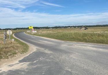
Trail Walking of 10 km to be discovered at Normandy, Manche, Bricqueville-sur-Mer. This trail is proposed by tracegps.
Description
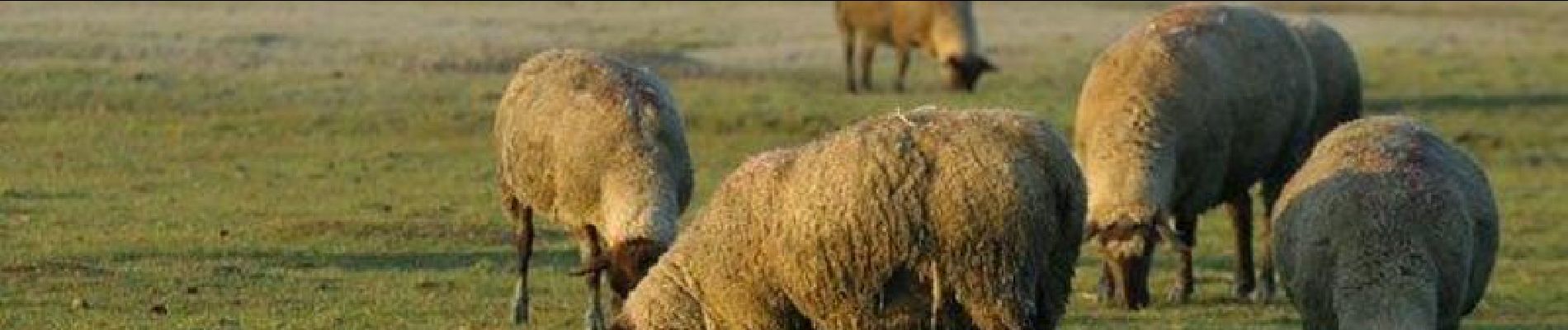
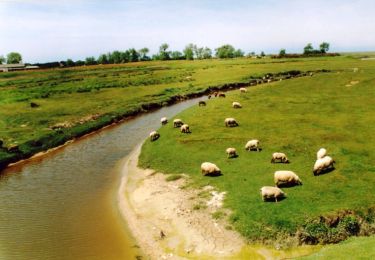
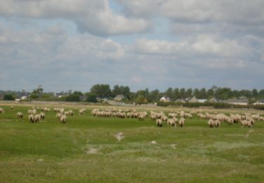
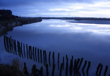
Balade de Bricqueville par la havre de la Vanlée, bras de mer dans lequel on trouve un paysage d’herbus et de moutons de prés salés. Ce site protégé est très fragile mais magnifique par tous les temps.
Positioning
Country:
France
Region :
Normandy
Department/Province :
Manche
Municipality :
Bricqueville-sur-Mer
Location:
Unknown
Start:(Dec)
Start:(UTM)
605209 ; 5418915 (30U) N.
Comments
Trails nearby
![Trail Walking Bréville-sur-Mer - Balade à Breville sur Mer - Photo](https://media.geolcdn.com/t/375/260/ext.jpg?maxdim=2&url=https%3A%2F%2Fservices.sitytrail.com%2FGeolivesWS%2FDownloadMedia.ashx%3FTrailID%3D172624%26Media%3D13990_6.jpg)
![Walking Walking](https://static1.geolcdn.com/sitytour/trail-icons/101.png)
Balade à Breville sur Mer
Walking
Medium
Bréville-sur-Mer,
Normandy,
Manche,
France
![](/images/other/stat-length.png)
14.2 km | 15.4 km-effort
3h 0min
![](https://static1.geolcdn.com/siteimages/upload/files/16400158638029165_repeat_loop_refresh_sync_direction_icon.png)
Yes
![Trail Mountain bike Bréhal - brehal 1 - Photo](https://media.geolcdn.com/t/375/260/ext.jpg?maxdim=2&url=https%3A%2F%2Fservices.sitytrail.com%2FGeolivesWS%2FDownloadMedia.ashx%3FTrailID%3D141198%26Media%3D20120725112747.jpg)
![Mountain bike Mountain bike](https://static1.geolcdn.com/sitytour/trail-icons/202.png)
![Trail Horseback riding Lingreville - Balade Sarah samedi - Photo](https://media.geolcdn.com/t/375/260/1ff22927-12ef-4acd-8c7d-2098b1cdad3c.jpg&format=jpg&maxdim=2)
![Horseback riding Horseback riding](https://static1.geolcdn.com/sitytour/trail-icons/301.png)
Balade Sarah samedi
Horseback riding
Medium
Lingreville,
Normandy,
Manche,
France
![](/images/other/stat-length.png)
19.7 km | 21 km-effort
45min
![](https://static1.geolcdn.com/siteimages/upload/files/16400158638029165_repeat_loop_refresh_sync_direction_icon.png)
Yes
![Trail Walking Bréhal - Les Villages - St Martin Le Vieux - Bréhal - Photo](https://media.geolcdn.com/t/375/260/ext.jpg?maxdim=2&url=https%3A%2F%2Fservices.sitytrail.com%2FGeolivesWS%2FDownloadMedia.ashx%3FTrailID%3D111765%26Media%3D8250_1.jpg)
![Walking Walking](https://static1.geolcdn.com/sitytour/trail-icons/101.png)
Les Villages - St Martin Le Vieux - Bréhal
Walking
Medium
Bréhal,
Normandy,
Manche,
France
![](/images/other/stat-length.png)
6.7 km | 7.3 km-effort
1h 45min
![](https://static1.geolcdn.com/siteimages/upload/files/16400158638029165_repeat_loop_refresh_sync_direction_icon.png)
Yes
![Trail Walking Bréhal - Les Marais - Saint Martin de Bréhal - Photo](https://media.geolcdn.com/t/375/260/ext.jpg?maxdim=2&url=https%3A%2F%2Fservices.sitytrail.com%2FGeolivesWS%2FDownloadMedia.ashx%3FTrailID%3D111764%26Media%3D8248_1.jpg)
![Walking Walking](https://static1.geolcdn.com/sitytour/trail-icons/101.png)
Les Marais - Saint Martin de Bréhal
Walking
Medium
(1)
Bréhal,
Normandy,
Manche,
France
![](/images/other/stat-length.png)
10 km | 10.5 km-effort
2h 30min
![](https://static1.geolcdn.com/siteimages/upload/files/16400158638029165_repeat_loop_refresh_sync_direction_icon.png)
Yes
![Trail Walking Bréhal - Le Chemin du Bois - Bréhal - Photo](https://media.geolcdn.com/t/375/260/ext.jpg?maxdim=2&url=https%3A%2F%2Fservices.sitytrail.com%2FGeolivesWS%2FDownloadMedia.ashx%3FTrailID%3D111762%26Media%3D8245_1.jpg)
![Walking Walking](https://static1.geolcdn.com/sitytour/trail-icons/101.png)
Le Chemin du Bois - Bréhal
Walking
Medium
Bréhal,
Normandy,
Manche,
France
![](/images/other/stat-length.png)
5.8 km | 6.6 km-effort
1h 45min
![](https://static1.geolcdn.com/siteimages/upload/files/16400158638029165_repeat_loop_refresh_sync_direction_icon.png)
Yes
![Trail Walking Lingreville - pont l eveque - Photo](https://media.geolcdn.com/t/375/260/ext.jpg?maxdim=2&url=https%3A%2F%2Fstatic1.geolcdn.com%2Fsiteimages%2Fupload%2Ffiles%2F1553511878bg_sport_marche.png)
![Walking Walking](https://static1.geolcdn.com/sitytour/trail-icons/101.png)
pont l eveque
Walking
Very difficult
Lingreville,
Normandy,
Manche,
France
![](/images/other/stat-length.png)
154 km | 183 km-effort
6h 2min
![](https://static1.geolcdn.com/siteimages/upload/files/16400158638029165_repeat_loop_refresh_sync_direction_icon.png)
No
![Trail Horseback riding Lingreville - Balade Sarah 2 eme jour - Photo](https://media.geolcdn.com/t/375/260/ae4bd52d-1bc8-4773-bc0f-6bc00a6c954a.jpg&format=jpg&maxdim=2)
![Horseback riding Horseback riding](https://static1.geolcdn.com/sitytour/trail-icons/301.png)
Balade Sarah 2 eme jour
Horseback riding
Medium
Lingreville,
Normandy,
Manche,
France
![](/images/other/stat-length.png)
25 km | 27 km-effort
54min
![](https://static1.geolcdn.com/siteimages/upload/files/16400158638029165_repeat_loop_refresh_sync_direction_icon.png)
Yes
![Trail Cycle Lingreville - 20070628Bernesq - Photo](https://media.geolcdn.com/t/375/260/ext.jpg?maxdim=2&url=https%3A%2F%2Fstatic1.geolcdn.com%2Fsiteimages%2Fupload%2Ffiles%2F1524743154velo.jpg)
![Cycle Cycle](https://static1.geolcdn.com/sitytour/trail-icons/200.png)
20070628Bernesq
Cycle
Very easy
Lingreville,
Normandy,
Manche,
France
![](/images/other/stat-length.png)
75 km | 85 km-effort
Unknown
![](https://static1.geolcdn.com/siteimages/upload/files/16400158638029165_repeat_loop_refresh_sync_direction_icon.png)
No