![](/images/other/stat-length.png)
![Trail Walking Bréhal - Les Champagnes - St Martin Le Vieux - Photo](https://media.geolcdn.com/t/1900/400/ext.pjpeg?maxdim=2&url=https%3A%2F%2Fstatic1.geolcdn.com%2Fsiteimages%2Fupload%2Ffiles%2F1553511878bg_sport_marche.png)
Les Champagnes - St Martin Le Vieux
tracegps
User
![Length](/images/other/stat-length.png)
Length
4.5 km
![Max alt](https://static1.geolcdn.com/siteimages/upload/files/1508320355ic_sort_altitude_max_24dp.png)
Max alt
42 m
![Uphill gradient](https://static1.geolcdn.com/siteimages/upload/files/1508320355ic_sort_den_pos_24dp.png)
Uphill gradient
52 m
![Km-Effort](/images/other/stat-length.png)
Km-Effort
5.2 km
![Min alt](https://static1.geolcdn.com/siteimages/upload/files/1508320355ic_sort_altitude_min_24dp.png)
Min alt
4 m
![Downhill gradient](https://static1.geolcdn.com/siteimages/upload/files/1508320355ic_sort_den_neg_24dp.png)
Downhill gradient
56 m
![Boucle](https://static1.geolcdn.com/siteimages/upload/files/16400158638029165_repeat_loop_refresh_sync_direction_icon.png)
Boucle
Yes
Creation date :
2014-12-10 00:00:00.0
Updated on :
2014-12-10 00:00:00.0
![Walking](https://static1.geolcdn.com/sitytour/trail-icons/101.png)
1h00
Difficulty : Easy
![Scan this QR Code to open this trail in the SityTrail application](https://capi.geolives.com/qq0zvz2zws4bq2lad0pu/sitytour/trails/111763/qr.png?size=200)
FREE GPS app for hiking
About
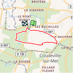
Trail Walking of 4.5 km to be discovered at Normandy, Manche, Bréhal. This trail is proposed by tracegps.
Description
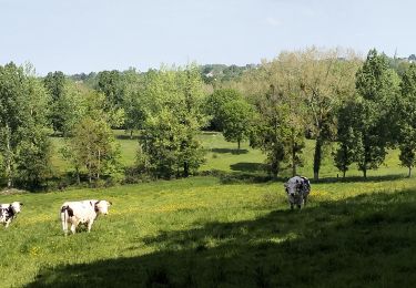
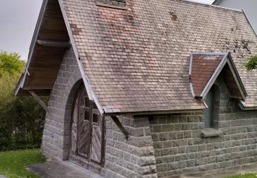
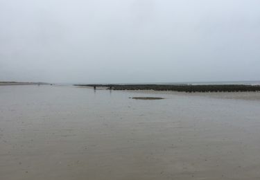
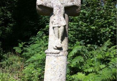
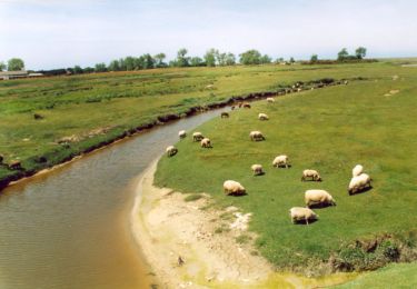
Promenade partant d'une belle église en ruine à St Martin le Vieux; quelques passages limites au printemps (de la boue jusqu'au moyeu de ma roue), passage le long de la Vanlée et d'une ancienne voie de chemin de fer.
Positioning
Country:
France
Region :
Normandy
Department/Province :
Manche
Municipality :
Bréhal
Location:
Unknown
Start:(Dec)
Start:(UTM)
606964 ; 5416631 (30U) N.
Comments
Trails nearby
![Trail Mountain bike Donville-les-Bains - 50-vtt-donville-21km-200m - Photo](https://media.geolcdn.com/t/375/260/1780a610-d28f-4f7f-bdad-d32483604bd0.jpg&format=jpg&maxdim=2)
![Mountain bike Mountain bike](https://static1.geolcdn.com/sitytour/trail-icons/202.png)
50-vtt-donville-21km-200m
Mountain bike
Medium
Donville-les-Bains,
Normandy,
Manche,
France
![](/images/other/stat-length.png)
21 km | 24 km-effort
1h 39min
![](https://static1.geolcdn.com/siteimages/upload/files/16400158638029165_repeat_loop_refresh_sync_direction_icon.png)
Yes
![Trail Mountain bike Donville-les-Bains - 50-vtt-donville-28km - Photo](https://media.geolcdn.com/t/375/260/283ae410-e7da-45fb-9b33-aeccc3fd5afc.jpg&format=jpg&maxdim=2)
![Mountain bike Mountain bike](https://static1.geolcdn.com/sitytour/trail-icons/202.png)
50-vtt-donville-28km
Mountain bike
Medium
Donville-les-Bains,
Normandy,
Manche,
France
![](/images/other/stat-length.png)
28 km | 31 km-effort
2h 7min
![](https://static1.geolcdn.com/siteimages/upload/files/16400158638029165_repeat_loop_refresh_sync_direction_icon.png)
Yes
![Trail Walking Donville-les-Bains - Donville Granville - Photo](https://media.geolcdn.com/t/375/260/ext.jpg?maxdim=2&url=https%3A%2F%2Fservices.sitytrail.com%2FGeolivesWS%2FDownloadMedia.ashx%3FTrailID%3D704938%26Media%3Dfix__20170225162805.jpg)
![Walking Walking](https://static1.geolcdn.com/sitytour/trail-icons/101.png)
Donville Granville
Walking
Easy
Donville-les-Bains,
Normandy,
Manche,
France
![](/images/other/stat-length.png)
5.8 km | 7.6 km-effort
1h 31min
![](https://static1.geolcdn.com/siteimages/upload/files/16400158638029165_repeat_loop_refresh_sync_direction_icon.png)
No
![Trail Walking Donville-les-Bains - BALANCE SUR LES PLAGES DE BREVILLE - Photo](https://media.geolcdn.com/t/375/260/ext.jpg?maxdim=2&url=https%3A%2F%2Fservices.sitytrail.com%2FGeolivesWS%2FDownloadMedia.ashx%3FTrailID%3D415348%26Media%3D20150502112556.jpg)
![Walking Walking](https://static1.geolcdn.com/sitytour/trail-icons/101.png)
BALANCE SUR LES PLAGES DE BREVILLE
Walking
Very easy
Donville-les-Bains,
Normandy,
Manche,
France
![](/images/other/stat-length.png)
18.3 km | 19.6 km-effort
4h 40min
![](https://static1.geolcdn.com/siteimages/upload/files/16400158638029165_repeat_loop_refresh_sync_direction_icon.png)
Yes
![Trail Walking Bréville-sur-Mer - Balade à Breville sur Mer - Photo](https://media.geolcdn.com/t/375/260/ext.jpg?maxdim=2&url=https%3A%2F%2Fservices.sitytrail.com%2FGeolivesWS%2FDownloadMedia.ashx%3FTrailID%3D172624%26Media%3D13990_6.jpg)
![Walking Walking](https://static1.geolcdn.com/sitytour/trail-icons/101.png)
Balade à Breville sur Mer
Walking
Medium
Bréville-sur-Mer,
Normandy,
Manche,
France
![](/images/other/stat-length.png)
14.2 km | 15.4 km-effort
3h 0min
![](https://static1.geolcdn.com/siteimages/upload/files/16400158638029165_repeat_loop_refresh_sync_direction_icon.png)
Yes
![Trail Mountain bike Bréhal - brehal 1 - Photo](https://media.geolcdn.com/t/375/260/ext.jpg?maxdim=2&url=https%3A%2F%2Fservices.sitytrail.com%2FGeolivesWS%2FDownloadMedia.ashx%3FTrailID%3D141198%26Media%3D20120725112747.jpg)
![Mountain bike Mountain bike](https://static1.geolcdn.com/sitytour/trail-icons/202.png)
![Trail Walking Donville-les-Bains - BALADE À GRANDVILLE - Photo](https://media.geolcdn.com/t/375/260/ext.jpg?maxdim=2&url=https%3A%2F%2Fservices.sitytrail.com%2FGeolivesWS%2FDownloadMedia.ashx%3FTrailID%3D414676%26Media%3D20150501144440.jpg)
![Walking Walking](https://static1.geolcdn.com/sitytour/trail-icons/101.png)
BALADE À GRANDVILLE
Walking
Easy
Donville-les-Bains,
Normandy,
Manche,
France
![](/images/other/stat-length.png)
18.3 km | 22 km-effort
4h 58min
![](https://static1.geolcdn.com/siteimages/upload/files/16400158638029165_repeat_loop_refresh_sync_direction_icon.png)
Yes
![Trail Walking Chanteloup - Le chant des Loups - Chanteloup - Photo](https://media.geolcdn.com/t/375/260/ext.jpg?maxdim=2&url=https%3A%2F%2Fservices.sitytrail.com%2FGeolivesWS%2FDownloadMedia.ashx%3FTrailID%3D111880%26Media%3D8727_2.jpg)
![Walking Walking](https://static1.geolcdn.com/sitytour/trail-icons/101.png)
Le chant des Loups - Chanteloup
Walking
Medium
Chanteloup,
Normandy,
Manche,
France
![](/images/other/stat-length.png)
9 km | 10.4 km-effort
2h 0min
![](https://static1.geolcdn.com/siteimages/upload/files/16400158638029165_repeat_loop_refresh_sync_direction_icon.png)
Yes
![Trail Walking Hudimesnil - Le Moulin du Pont - Hudimesnil - Photo](https://media.geolcdn.com/t/375/260/ext.jpg?maxdim=2&url=https%3A%2F%2Fservices.sitytrail.com%2FGeolivesWS%2FDownloadMedia.ashx%3FTrailID%3D111879%26Media%3D8726_1.jpg)
![Walking Walking](https://static1.geolcdn.com/sitytour/trail-icons/101.png)
Le Moulin du Pont - Hudimesnil
Walking
Medium
(1)
Hudimesnil,
Normandy,
Manche,
France
![](/images/other/stat-length.png)
14.8 km | 17.3 km-effort
3h 30min
![](https://static1.geolcdn.com/siteimages/upload/files/16400158638029165_repeat_loop_refresh_sync_direction_icon.png)
Yes