Trail Cycle Château-Salins - Le Pays du Saulnois,  l'histoire du sel. (Circuit 17) - Photo

Le Pays du Saulnois, l'histoire du sel. (Circuit 17)

 tracegps
tracegps

User

© OpenStreetMap contributors
Length
Length
52 km
Max alt
Max alt
324 m
Uphill gradient
Uphill gradient
728 m
Km-Effort
Km-Effort  
62 km
Min alt
Min alt
198 m
Downhill gradient
Downhill gradient
728 m
Boucle
Boucle
Yes
Creation date :
2014-12-10 00:00:00.0
Updated on :
2014-12-10 00:00:00.0

(1 Reviews)

Cycle
Cycle
3h00
Difficulty : Difficult

Scan this QR Code to open this trail in the SityTrail application

FREE GPS app for hiking

Logo SityTrail SityTrail

IGN / Geographical institutes

Download SityTrail from the App Store Download SityTrail from Google Play

Logo SityTrail SityTrail World

The world is yours!

Download SityTrail from the App Store Download SityTrail from Google Play Download SityTrail on Huawei AppGallery

About

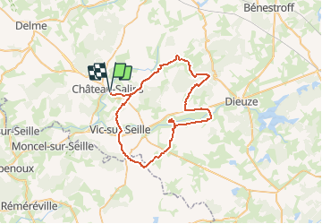
Trail Cycle of 52 km to be discovered at Grand Est, Moselle, Château-Salins. This trail is proposed by tracegps.

Description

Le Parc Naturel Régional de Lorraine vous propose dans un Pays où l’histoire est étroitement liée à celle de l’or blanc lorrain. Ici, le Plateau Lorrain se dessine et forme un ensemble varié de paysages aux héritages complexes. Départ du camping de Château-Salins ou Gites Panda à Marsal et Blanche-Église. Retrouvez ici le plan et descriptif du circuit. Vous pouvez obtenir le guide par courrier auprès du Parc Naturel Régional de Lorraine.

Elevation profile

Photos

Positioning

Country:
France
Region :
Grand Est
Department/Province :
Moselle
Municipality :
Château-Salins
Location:
Unknown
Start:(UTM)
317595 ; 5410345 (32U) N.

Comments

Please log in to post a review or rate the element


Trails nearby

Trail Walking Moyenvic - les hauts de Sain-Jean - Photo
Walking
viverols

Walking

Very easy
(1)
Moyenvic, Grand Est, Moselle, France
7.2 km | 9.1 km-effort
2h 0min
Yes
Trail Walking Château-Salins - Vic sur seille au départ de Château Salins  - Photo
Walking
jean-marie.parachini

Walking

Medium
Château-Salins, Grand Est, Moselle, France
18.9 km | 23 km-effort
6h 35min
Yes
Trail Walking Moyenvic - sortie 4 5 - Photo
Walking
bellophilippe

Walking

Difficult
Moyenvic, Grand Est, Moselle, France
11.2 km | 12.5 km-effort
1h 57min
Yes
Trail Quad Lubécourt - rando saulnois - Photo
Quad
stouf07

Quad

Medium
Lubécourt, Grand Est, Moselle, France
99 km | 121 km-effort
4h 3min
No
Trail Walking Moyenvic - boucle départ moyenvic  - Photo
Walking
bellophilippe

Walking

Very difficult
Moyenvic, Grand Est, Moselle, France
27 km | 33 km-effort
5h 22min
Yes
Trail Walking Vic-sur-Seille - vic moyenvic par stade - Photo
Walking
bellophilippe

Walking

Easy
Vic-sur-Seille, Grand Est, Moselle, France
4.2 km | 4.8 km-effort
54min
No
Trail Walking Moyenvic - Moyenvic vic boucle  - Photo
Walking
bellophilippe

Walking

Medium
Moyenvic, Grand Est, Moselle, France
14.8 km | 18.5 km-effort
3h 24min
Yes
Trail Walking Moyenvic - sortie du 20923 - Photo
Walking
bellophilippe

Walking

Medium
Moyenvic, Grand Est, Moselle, France
14.7 km | 17 km-effort
3h 24min
Yes
Trail Walking Vic-sur-Seille - Vic sur Seille  - Photo
Walking
didier cornelius

Walking

Difficult
Vic-sur-Seille, Grand Est, Moselle, France
14.9 km | 18.3 km-effort
3h 0min
Yes


Close
My subscriptions