Trail Walking Coursan-en-Othe - Circuit du Coursannais - Coursan-en-Othe - Photo

Circuit du Coursannais - Coursan-en-Othe

 tracegps
tracegps

User

© OpenStreetMap contributors
Length
Length
12 km
Max alt
Max alt
178 m
Uphill gradient
Uphill gradient
152 m
Km-Effort
Km-Effort  
14 km
Min alt
Min alt
119 m
Downhill gradient
Downhill gradient
150 m
Boucle
Boucle
Yes
Creation date :
2014-12-10 00:00:00.0
Updated on :
2014-12-10 00:00:00.0

(1 Reviews)

Walking
Walking
3h00
Difficulty : Medium

Scan this QR Code to open this trail in the SityTrail application

FREE GPS app for hiking

Logo SityTrail SityTrail

IGN / Geographical institutes

Download SityTrail from the App Store Download SityTrail from Google Play

Logo SityTrail SityTrail World

The world is yours!

Download SityTrail from the App Store Download SityTrail from Google Play Download SityTrail on Huawei AppGallery

About

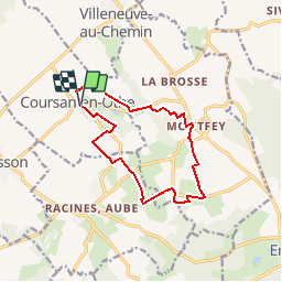
Trail Walking of 12 km to be discovered at Grand Est, Aube, Coursan-en-Othe. This trail is proposed by tracegps.

Description

Circuit proposé par l’Office du Tourisme du Chaourçois en Pays d’Armance. Départ de la place Rambourgt à Coursan-en-Othe. A voir : Le très beau parc « idéal pour pique-niquer en famille » se dessine autour des douves de l’ancien château datant du 15e siècle. Ses pierres auraient permis de reconstruire le village et le nouveau château. Seule une tour a pu être sauvée des ruines. La flore : Au milieu d’arbres séculaires, se distinguent deux espèces rares : Un Cyprés Chauve de 350 ans, résineux qui perd ses aiguilles en automne. Un Tulipier de Virginie, haut de plus de 30 m, superbe fin mai : début juin par ses étonnantes fleurs en forme de tulipes. Retrouvez ce circuit sur le site de l’Office du Tourisme.

Elevation profile

Photos

Positioning

Country:
France
Region :
Grand Est
Department/Province :
Aube
Municipality :
Coursan-en-Othe
Location:
Unknown
Start:(UTM)
562560 ; 5324547 (31U) N.

Comments

Please log in to post a review or rate the element


excellent


Trails nearby

Trail Walking Coursan-en-Othe - COURSAN EN OTH - Photo
Walking
danpar

Walking

Very easy
Coursan-en-Othe, Grand Est, Aube, France
20 km | 23 km-effort
5h 34min
Yes
Trail Walking Villeneuve-au-Chemin - 2024-04 Villeneuve  - Photo
Walking
letzelter

Walking

Medium
Villeneuve-au-Chemin, Grand Est, Aube, France
7.5 km | 9.6 km-effort
2h 22min
No
Trail Walking Coursan-en-Othe - Coursan en Othe - Photo
Walking
randobe

Walking

Very difficult
Coursan-en-Othe, Grand Est, Aube, France
21 km | 25 km-effort
6h 46min
Yes
Trail Walking Ervy-le-Châtel - balisage - Photo
Walking
bougnaou

Walking

Very easy
Ervy-le-Châtel, Grand Est, Aube, France
8 km | 9.3 km-effort
2h 24min
No
Trail Walking Vosnon - vosnon - Photo
Walking
richardetchantal

Walking

Difficult
Vosnon, Grand Est, Aube, France
11.3 km | 14.7 km-effort
2h 53min
No
Trail Walking Racines, Aube - racines - Photo
Walking
bougnaou

Walking

Very easy
Racines, Aube, Grand Est, Aube, France
12.5 km | 14.1 km-effort
2h 51min
Yes
Trail Walking Villeneuve-au-Chemin - Villeneuve au chemin 12.6km réel - Photo
Walking
rando-nico

Walking

Very easy
Villeneuve-au-Chemin, Grand Est, Aube, France
12.6 km | 15.8 km-effort
3h 24min
Yes
Trail Mountain bike Villeneuve-au-Chemin - Villeneuve a.c. 2012 - Photo
Mountain bike
Tollard

Mountain bike

Medium
Villeneuve-au-Chemin, Grand Est, Aube, France
57 km | 73 km-effort
4h 37min
Yes
Trail Mountain bike Villeneuve-au-Chemin - Villeneuve a.c. 2012 - Photo
Mountain bike
Tollard

Mountain bike

Medium
Villeneuve-au-Chemin, Grand Est, Aube, France
57 km | 73 km-effort
4h 37min
Yes


Close
My subscriptions