Trail Walking Broons - Sur les routes de Broons (Circuit Bleu) - Photo

Sur les routes de Broons (Circuit Bleu)

 tracegps
tracegps

User

© OpenStreetMap contributors
Length
Length
10.4 km
Max alt
Max alt
115 m
Uphill gradient
Uphill gradient
119 m
Km-Effort
Km-Effort  
12 km
Min alt
Min alt
71 m
Downhill gradient
Downhill gradient
119 m
Boucle
Boucle
Yes
Creation date :
2014-12-10 00:00:00.0
Updated on :
2014-12-10 00:00:00.0

(0 Reviews)

Walking
Walking
2h34
Difficulty : Medium

Scan this QR Code to open this trail in the SityTrail application

FREE GPS app for hiking

Logo SityTrail SityTrail

IGN / Geographical institutes

Download SityTrail from the App Store Download SityTrail from Google Play

Logo SityTrail SityTrail World

The world is yours!

Download SityTrail from the App Store Download SityTrail from Google Play Download SityTrail on Huawei AppGallery

About

Trail Walking of 10.4 km to be discovered at Brittany, Côtes-d'Armor, Broons. This trail is proposed by tracegps.

Description

Circuit proposé par la communauté de communes du Pays de du Geusclin. Départ du Super U de Broons. Retrouvez ce circuit sur le site du pays de Du Guesclin . Ce circuit a été numérisé par les randonneurs du CODEPEM . Merci à Jean-Marie.

Elevation profile

Photos

Positioning

Country:
France
Region :
Brittany
Department/Province :
Côtes-d'Armor
Municipality :
Broons
Location:
Unknown
Start:(UTM)
555589 ; 5351772 (30U) N.

Trails nearby

Trail Mountain bike Broons - Sur les routes de Broons (Circuit Bleu) - Photo
Mountain bike
tracegps

Mountain bike

Easy
Broons, Brittany, Côtes-d'Armor, France
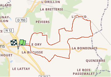
10.4 km | 12 km-effort
49min
Yes
Trail Mountain bike Broons - Broons Lanrelas forêt  - Photo
Mountain bike
Simon F

Mountain bike

Difficult
Broons, Brittany, Côtes-d'Armor, France
28 km | 33 km-effort
1h 47min
Yes
Trail Mountain bike Broons - broons rando - Photo
Mountain bike
hletexier

Mountain bike

Medium
Broons, Brittany, Côtes-d'Armor, France
34 km | 41 km-effort
3h 3min
Yes


Close
My subscriptions