![](/images/other/stat-length.png)
![Trail Walking Saint-Just-Ibarre - Chemin du Piémont Pyrénéen - De Saint Just Ibarre à Saint Jean Pied de Port - Photo](https://media.geolcdn.com/t/1900/400/ext.pjpeg?maxdim=2&url=https%3A%2F%2Fservices.sitytrail.com%2FGeolivesWS%2FDownloadMedia.ashx%3FTrailID%3D111321%26Media%3D6994_2.jpg)
Chemin du Piémont Pyrénéen - De Saint Just Ibarre à Saint Jean Pied de Port
tracegps
User
![Length](/images/other/stat-length.png)
![Max alt](https://static1.geolcdn.com/siteimages/upload/files/1508320355ic_sort_altitude_max_24dp.png)
![Uphill gradient](https://static1.geolcdn.com/siteimages/upload/files/1508320355ic_sort_den_pos_24dp.png)
![Km-Effort](/images/other/stat-length.png)
![Min alt](https://static1.geolcdn.com/siteimages/upload/files/1508320355ic_sort_altitude_min_24dp.png)
![Downhill gradient](https://static1.geolcdn.com/siteimages/upload/files/1508320355ic_sort_den_neg_24dp.png)
![Boucle](https://static1.geolcdn.com/siteimages/upload/files/16400158638029165_repeat_loop_refresh_sync_direction_icon.png)
![Walking](https://static1.geolcdn.com/sitytour/trail-icons/101.png)
5h45
Difficulty : Difficult
![Scan this QR Code to open this trail in the SityTrail application](https://capi.geolives.com/qq0zvz2zws4bq2lad0pu/sitytour/trails/111321/qr.png?size=200)
FREE GPS app for hiking
About
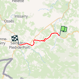
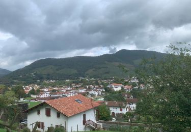
Trail Walking of 21 km to be discovered at New Aquitaine, Pyrénées-Atlantiques, Saint-Just-Ibarre. This trail is proposed by tracegps.
Description
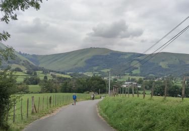
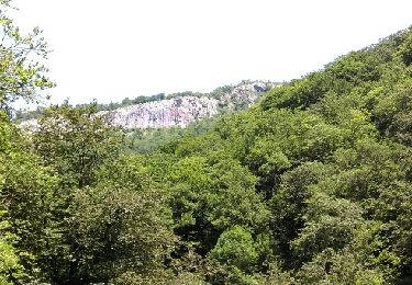
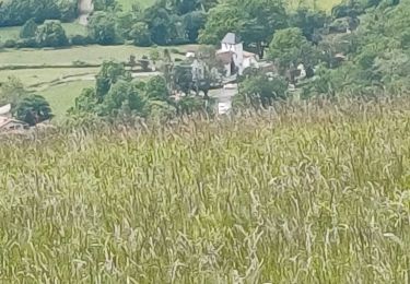
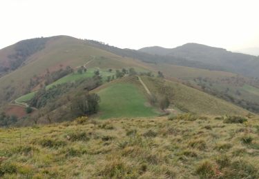
Cette ultime étape amène les randonneurs et les pèlerins à rejoindre le GR® 65 pour franchir le dernier tronçon qui les sépare de Saint-Jean-Pied-de-Port,via Saint-Jean-Le-Vieux. C´est une étape de pleine nature, qui emprunte tout d´abord une petite route tranquille et grimpe ensuite sur le mont qui domine le col de Gamia. De là-haut, par beau temps, vue panoramique garantie sur la chaîne des Pyrénées que l´on sent toutes proches. Retrouvez d’autres informations et la fiche descriptive sur le site Pays Basque et Béarn.
Positioning
Comments
Trails nearby
![Trail Walking Musculdy - MUSCULUDY du col d'Osquich à la chapelle Saint-Antoine](https://media.geolcdn.com/t/375/260/0cdf3b06-90b3-43fa-99a7-e69d840c8f75.jpg&format=jpg&maxdim=2)
![Walking Walking](https://static1.geolcdn.com/sitytour/trail-icons/101.png)
Walking
![](/images/other/stat-length.png)
![](https://static1.geolcdn.com/siteimages/upload/files/16400158638029165_repeat_loop_refresh_sync_direction_icon.png)
![Trail Walking Saint-Just-Ibarre - sources de la Bidouze fait et trace nettoyee - Photo](https://media.geolcdn.com/t/375/260/ext.jpg?maxdim=2&url=https%3A%2F%2Fservices.sitytrail.com%2FGeolivesWS%2FDownloadMedia.ashx%3FTrailID%3D997163%26Media%3Dfix__20180630150554.jpg)
![Walking Walking](https://static1.geolcdn.com/sitytour/trail-icons/101.png)
Walking
![](/images/other/stat-length.png)
![](https://static1.geolcdn.com/siteimages/upload/files/16400158638029165_repeat_loop_refresh_sync_direction_icon.png)
![Trail Walking Bunus - Bunus - Photo](https://media.geolcdn.com/t/375/260/3261b3a6-748b-4806-9ca3-7d787d4fa6fb.jpg&format=jpg&maxdim=2)
![Walking Walking](https://static1.geolcdn.com/sitytour/trail-icons/101.png)
Walking
![](/images/other/stat-length.png)
![](https://static1.geolcdn.com/siteimages/upload/files/16400158638029165_repeat_loop_refresh_sync_direction_icon.png)
![Trail Walking Ibarrolle - Au-dessus de IBAROLLE - Photo](https://media.geolcdn.com/t/375/260/f2c0c960-4a58-4010-9cae-cc6721fb104f.jpg&format=jpg&maxdim=2)
![Walking Walking](https://static1.geolcdn.com/sitytour/trail-icons/101.png)
Walking
![](/images/other/stat-length.png)
![](https://static1.geolcdn.com/siteimages/upload/files/16400158638029165_repeat_loop_refresh_sync_direction_icon.png)
![Trail Walking Saint-Just-Ibarre - Sources de la Bidouze - Photo](https://media.geolcdn.com/t/375/260/ext.jpg?maxdim=2&url=https%3A%2F%2Fstatic1.geolcdn.com%2Fsiteimages%2Fupload%2Ffiles%2F1553511878bg_sport_marche.png)
![Walking Walking](https://static1.geolcdn.com/sitytour/trail-icons/101.png)
Walking
![](/images/other/stat-length.png)
![](https://static1.geolcdn.com/siteimages/upload/files/16400158638029165_repeat_loop_refresh_sync_direction_icon.png)
![Trail Walking Saint-Just-Ibarre - bidouze fait - Photo](https://media.geolcdn.com/t/375/260/ext.jpg?maxdim=2&url=https%3A%2F%2Fservices.sitytrail.com%2FGeolivesWS%2FDownloadMedia.ashx%3FTrailID%3D999627%26Media%3Dfix__20180706140731.jpg)
![Walking Walking](https://static1.geolcdn.com/sitytour/trail-icons/101.png)
Walking
![](/images/other/stat-length.png)
![](https://static1.geolcdn.com/siteimages/upload/files/16400158638029165_repeat_loop_refresh_sync_direction_icon.png)
![Trail Walking Saint-Just-Ibarre - Pic d'Etchecortia en boucle par le hameau d'Arla et la source de la Bidouze - Photo](https://media.geolcdn.com/t/375/260/ext.jpg?maxdim=2&url=https%3A%2F%2Fservices.sitytrail.com%2FGeolivesWS%2FDownloadMedia.ashx%3FTrailID%3D105230%26Media%3D8879_4.jpg)
![Walking Walking](https://static1.geolcdn.com/sitytour/trail-icons/101.png)
Walking
![](/images/other/stat-length.png)
![](https://static1.geolcdn.com/siteimages/upload/files/16400158638029165_repeat_loop_refresh_sync_direction_icon.png)
![Trail Walking Larceveau-Arros-Cibits - Compostelle Larceveaux St Jean pied de port - Photo](https://media.geolcdn.com/t/375/260/fc633087-49b8-4989-a7d4-47f29a8eaa33.jpg&format=jpg&maxdim=2)
![Walking Walking](https://static1.geolcdn.com/sitytour/trail-icons/101.png)
Walking
![](/images/other/stat-length.png)
![](https://static1.geolcdn.com/siteimages/upload/files/16400158638029165_repeat_loop_refresh_sync_direction_icon.png)
![Trail On foot Musculdy - MUSCULDY col d'Osquich journée des presidents et animateurs du 9/11/2024](https://media.geolcdn.com/t/375/260/ext.jpg?maxdim=2&url=https%3A%2F%2Fstatic1.geolcdn.com%2Fsiteimages%2Fupload%2Ffiles%2F1545311037marcheuse_200dpi.jpg)
![On foot On foot](https://static1.geolcdn.com/sitytour/trail-icons/100.png)
On foot
![](/images/other/stat-length.png)
![](https://static1.geolcdn.com/siteimages/upload/files/16400158638029165_repeat_loop_refresh_sync_direction_icon.png)