Trail Walking Orthez - Orthez - Laqueyre - Photo
 tracegps
tracegps

User

© OpenStreetMap contributors
Length
Length
9.5 km
Max alt
Max alt
176 m
Uphill gradient
Uphill gradient
164 m
Km-Effort
Km-Effort  
11.6 km
Min alt
Min alt
75 m
Downhill gradient
Downhill gradient
164 m
Boucle
Boucle
Yes
Creation date :
2014-12-10 00:00:00.0
Updated on :
2014-12-10 00:00:00.0

(0 Reviews)

Walking
Walking
3h00
Difficulty : Medium

Scan this QR Code to open this trail in the SityTrail application

FREE GPS app for hiking

Logo SityTrail SityTrail

IGN / Geographical institutes

Download SityTrail from the App Store Download SityTrail from Google Play

Logo SityTrail SityTrail World

The world is yours!

Download SityTrail from the App Store Download SityTrail from Google Play Download SityTrail on Huawei AppGallery

About

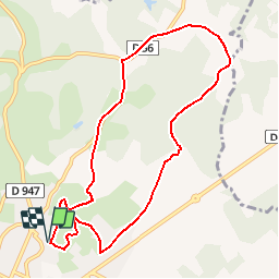
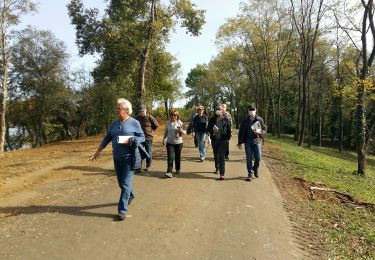
Trail Walking of 9.5 km to be discovered at New Aquitaine, Pyrénées-Atlantiques, Orthez. This trail is proposed by tracegps.

Description

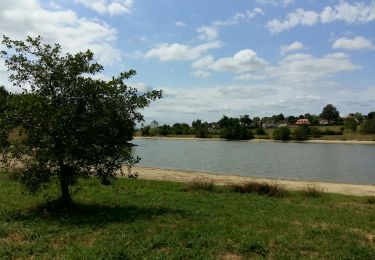
L´itinéraire se développe au nord du lac du Grécq sur les crêtes bordant le bassin versant. Les ouvertures paysagères vers Orthez ou les Pyrénées alternent avec des passages forestiers et ombragés. C´est un très ancien itinéraire qu´empruntaient les pèlerins de Compostelle et qui reliait la Tarbelli (nom latin pour désigner Dax) à Orthez par la ligne des crêtes. Retrouvez d’autres informations et la fiche descriptive sur le site Pays Basque et Béarn.

Elevation profile

Photos

Positioning

Country:
France
Region :
New Aquitaine
Department/Province :
Pyrénées-Atlantiques
Municipality :
Orthez
Location:
Unknown
Start:(UTM)
680171 ; 4818296 (30T) N.

Trails nearby

Trail Walking Orthez - ORTHEZ  GRvP 29 02 2024 - Photo
Walking
GUIDE
marmotte65

Walking

Difficult
Orthez, New Aquitaine, Pyrénées-Atlantiques, France
14.4 km | 17.2 km-effort
5h 39min
No
Trail On foot Orthez - PARI 2024 Orthez / Sault de Navailles
On foot
GUIDE
marmotte65

On foot

Easy
Orthez, New Aquitaine, Pyrénées-Atlantiques, France
14.4 km | 17.2 km-effort
3h 54min
No
Trail Walking Orthez - ORTHEZ Medieval (CCLO) G4 labélisation fait  - Photo
Walking
GUIDE
marmotte65

Walking

Easy
Orthez, New Aquitaine, Pyrénées-Atlantiques, France
6 km | 7.6 km-effort
1h 53min
Yes
Trail Walking Orthez - ORTHEZ Laqueyre M1 et M2  le 14/12/2022
Walking
GUIDE
marmotte65

Walking

Difficult
Orthez, New Aquitaine, Pyrénées-Atlantiques, France
9.9 km | 12.2 km-effort
4h 46min
Yes
Trail Walking Orthez - ORTHEZ Lac de Biron - Photo
Walking
GUIDE
marmotte65

Walking

Very easy
Orthez, New Aquitaine, Pyrénées-Atlantiques, France
3.5 km | 3.8 km-effort
1h 16min
No
Trail Running Orthez - Géocaching Laqueyre - Photo
Running
tracegps

Running

Difficult
Orthez, New Aquitaine, Pyrénées-Atlantiques, France
10.8 km | 13.6 km-effort
1h 30min
Yes
Trail Mountain bike Orthez - Géocaching Laqueyre - Photo
Mountain bike
tracegps

Mountain bike

Medium
Orthez, New Aquitaine, Pyrénées-Atlantiques, France
10.8 km | 13.6 km-effort
1h 0min
Yes
Trail Walking Orthez - Géocaching Laqueyre - Photo
Walking
tracegps

Walking

Medium
Orthez, New Aquitaine, Pyrénées-Atlantiques, France
10.8 km | 13.6 km-effort
3h 0min
Yes
Trail Walking Orthez - 2024- St Jacques -#1 - Photo
Walking
waggy

Walking

Medium
Orthez, New Aquitaine, Pyrénées-Atlantiques, France
23 km | 31 km-effort
6h 27min
No


Close
My subscriptions