Trail Walking Bouilly - Le sentier des moutons - 13 km - Bouilly             - Photo

Le sentier des moutons - 13 km - Bouilly

 tracegps
tracegps

User

© OpenStreetMap contributors
Length
Length
12.7 km
Max alt
Max alt
301 m
Uphill gradient
Uphill gradient
250 m
Km-Effort
Km-Effort  
16 km
Min alt
Min alt
160 m
Downhill gradient
Downhill gradient
250 m
Boucle
Boucle
Yes
Creation date :
2014-12-10 00:00:00.0
Updated on :
2014-12-10 00:00:00.0

(1 Reviews)

Walking
Walking
3h10
Difficulty : Difficult

Scan this QR Code to open this trail in the SityTrail application

FREE GPS app for hiking

Logo SityTrail SityTrail

IGN / Geographical institutes

Download SityTrail from the App Store Download SityTrail from Google Play

Logo SityTrail SityTrail World

The world is yours!

Download SityTrail from the App Store Download SityTrail from Google Play Download SityTrail on Huawei AppGallery

About

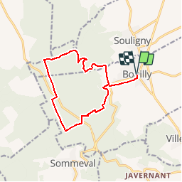
Trail Walking of 12.7 km to be discovered at Grand Est, Aube, Bouilly. This trail is proposed by tracegps.

Description

Circuit proposé par l’Office de Tourisme du Pays d’Othe. Départ de la place du champ-Pilé devant l’église de Bouilly. Retrouvez ce circuit sur le site de l’Office du Tourisme. Ce circuit a été numérisé par les randonneurs du CODEPEM. Merci à Jean-Marie.

Elevation profile

Photos

Positioning

Country:
France
Region :
Grand Est
Department/Province :
Aube
Municipality :
Bouilly
Location:
Unknown
Start:(UTM)
574123 ; 5338242 (31U) N.

Comments

Please log in to post a review or rate the element


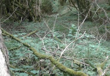
Circuit très ombragé agréable liés de journée très ensoleillée


Trails nearby

Trail Walking Bouilly - Bouilly le 30.07.22 (9.6kms) N° 2 - Photo
Walking
COTELEVELYNE

Walking

Medium
(1)
Bouilly, Grand Est, Aube, France
8.1 km | 10.5 km-effort
2h 23min
Yes
Trail Walking Souligny - Souligny 16km le 11/06/2019 - Photo
Walking
francis1952

Walking

Difficult
(1)
Souligny, Grand Est, Aube, France
16 km | 0 m-effort
3h 9min
Yes
Trail Mountain bike Laines-aux-Bois - montaigutour toto aout217 - Photo
Mountain bike
Tollard

Mountain bike

Difficult
(1)
Laines-aux-Bois, Grand Est, Aube, France
31 km | 42 km-effort
3h 6min
Yes
Trail Mountain bike Laines-aux-Bois - hors piste phiphi - Photo
Mountain bike
Tollard

Mountain bike

Difficult
(1)
Laines-aux-Bois, Grand Est, Aube, France
26 km | 35 km-effort
3h 11min
No
Trail Walking Laines-aux-Bois - Laines Aux Bois - Photo
Walking
FPortier

Walking

Medium
Laines-aux-Bois, Grand Est, Aube, France
8 km | 10.2 km-effort
2h 11min
Yes
Trail Walking Laines-aux-Bois - Lainesauxbois7kmPR - Photo
Walking
FPortier

Walking

Medium
(1)
Laines-aux-Bois, Grand Est, Aube, France
7 km | 9 km-effort
2h 3min
Yes
Trail Walking Sommeval - Bucey250623024Bis - Photo
Walking
FPortier

Walking

Medium
(1)
Sommeval, Grand Est, Aube, France
8.7 km | 10.9 km-effort
2h 29min
Yes
Trail Walking Laines-aux-Bois - Laines aux Bois - Photo
Walking
FPortier

Walking

Difficult
(1)
Laines-aux-Bois, Grand Est, Aube, France
9.5 km | 12.1 km-effort
2h 46min
Yes
Trail Walking Sommeval - Sommeval 10 kms - Photo
Walking
FPortier

Walking

Medium
Sommeval, Grand Est, Aube, France
9.7 km | 12 km-effort
2h 49min
Yes


Close
My subscriptions