![](/images/other/stat-length.png)
![Trail Walking Aix-Villemaur-Pâlis - Les Hameaux d'Aix-en-Othe - Photo](https://media.geolcdn.com/t/1900/400/ext.pjpeg?maxdim=2&url=https%3A%2F%2Fservices.sitytrail.com%2FGeolivesWS%2FDownloadMedia.ashx%3FTrailID%3D111240%26Media%3D6793_3.jpg)
Les Hameaux d'Aix-en-Othe
tracegps
User
![Length](/images/other/stat-length.png)
Length
23 km
![Max alt](https://static1.geolcdn.com/siteimages/upload/files/1508320355ic_sort_altitude_max_24dp.png)
Max alt
243 m
![Uphill gradient](https://static1.geolcdn.com/siteimages/upload/files/1508320355ic_sort_den_pos_24dp.png)
Uphill gradient
341 m
![Km-Effort](/images/other/stat-length.png)
Km-Effort
28 km
![Min alt](https://static1.geolcdn.com/siteimages/upload/files/1508320355ic_sort_altitude_min_24dp.png)
Min alt
128 m
![Downhill gradient](https://static1.geolcdn.com/siteimages/upload/files/1508320355ic_sort_den_neg_24dp.png)
Downhill gradient
341 m
![Boucle](https://static1.geolcdn.com/siteimages/upload/files/16400158638029165_repeat_loop_refresh_sync_direction_icon.png)
Boucle
Yes
Creation date :
2014-12-10 00:00:00.0
Updated on :
2014-12-10 00:00:00.0
![Walking](https://static1.geolcdn.com/sitytour/trail-icons/101.png)
6h00
Difficulty : Very difficult
![Scan this QR Code to open this trail in the SityTrail application](https://capi.geolives.com/qq0zvz2zws4bq2lad0pu/sitytour/trails/111240/qr.png?size=200)
FREE GPS app for hiking
About
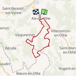
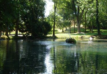
Trail Walking of 23 km to be discovered at Grand Est, Aube, Aix-Villemaur-Pâlis. This trail is proposed by tracegps.
Description
Circuit proposé par l’Office de Tourisme du Pays d’Othe. Départ de la place Thuillier à Aix-en-Othe. Retrouvez ce circuit sur le site de l’Office du Tourisme.
Positioning
Country:
France
Region :
Grand Est
Department/Province :
Aube
Municipality :
Aix-Villemaur-Pâlis
Location:
Aix-en-Othe
Start:(Dec)
Start:(UTM)
554356 ; 5341313 (31U) N.
Comments
Trails nearby
![Trail On foot Aix-Villemaur-Pâlis - Aix en Othe-Vaujurennes - Photo](https://media.geolcdn.com/t/375/260/ext.jpg?maxdim=2&url=https%3A%2F%2Fstatic1.geolcdn.com%2Fsiteimages%2Fupload%2Ffiles%2F1545311037marcheuse_200dpi.jpg)
![On foot On foot](https://static1.geolcdn.com/sitytour/trail-icons/100.png)
Aix en Othe-Vaujurennes
On foot
Medium
(1)
Aix-Villemaur-Pâlis,
Grand Est,
Aube,
France
![](/images/other/stat-length.png)
11 km | 13.7 km-effort
2h 30min
![](https://static1.geolcdn.com/siteimages/upload/files/16400158638029165_repeat_loop_refresh_sync_direction_icon.png)
Yes
![Trail Walking Aix-Villemaur-Pâlis - Bois des Brosses - Photo](https://media.geolcdn.com/t/375/260/8b3bc913-10c0-4ba8-9985-434accbe669e.jpg&format=jpg&maxdim=2)
![Walking Walking](https://static1.geolcdn.com/sitytour/trail-icons/101.png)
Bois des Brosses
Walking
Easy
Aix-Villemaur-Pâlis,
Grand Est,
Aube,
France
![](/images/other/stat-length.png)
7.7 km | 8.9 km-effort
2h 5min
![](https://static1.geolcdn.com/siteimages/upload/files/16400158638029165_repeat_loop_refresh_sync_direction_icon.png)
Yes
![Trail Walking Aix-Villemaur-Pâlis - Villemaur sur Vanne - Photo](https://media.geolcdn.com/t/375/260/077714cb-b931-402d-a46a-1b9837d21fba.jpg&format=jpg&maxdim=2)
![Walking Walking](https://static1.geolcdn.com/sitytour/trail-icons/101.png)
Villemaur sur Vanne
Walking
Very easy
Aix-Villemaur-Pâlis,
Grand Est,
Aube,
France
![](/images/other/stat-length.png)
9.8 km | 11.7 km-effort
2h 37min
![](https://static1.geolcdn.com/siteimages/upload/files/16400158638029165_repeat_loop_refresh_sync_direction_icon.png)
Yes
![Trail Walking Aix-Villemaur-Pâlis - La Vove - Aix en Othe - Photo](https://media.geolcdn.com/t/375/260/ext.jpg?maxdim=2&url=https%3A%2F%2Fservices.sitytrail.com%2FGeolivesWS%2FDownloadMedia.ashx%3FTrailID%3D172786%26Media%3D14215_4.jpg)
![Walking Walking](https://static1.geolcdn.com/sitytour/trail-icons/101.png)
La Vove - Aix en Othe
Walking
Medium
(1)
Aix-Villemaur-Pâlis,
Grand Est,
Aube,
France
![](/images/other/stat-length.png)
10.2 km | 12.3 km-effort
2h 30min
![](https://static1.geolcdn.com/siteimages/upload/files/16400158638029165_repeat_loop_refresh_sync_direction_icon.png)
Yes
![Trail Walking Aix-Villemaur-Pâlis - La Vove - Bois de la Brosse - Photo](https://media.geolcdn.com/t/375/260/ext.jpg?maxdim=2&url=https%3A%2F%2Fservices.sitytrail.com%2FGeolivesWS%2FDownloadMedia.ashx%3FTrailID%3D156019%26Media%3D3640a2a1-46ce-4143-b05f-39c0dd8ad6c4.JPG)
![Walking Walking](https://static1.geolcdn.com/sitytour/trail-icons/101.png)
La Vove - Bois de la Brosse
Walking
Easy
Aix-Villemaur-Pâlis,
Grand Est,
Aube,
France
![](/images/other/stat-length.png)
9.8 km | 11.9 km-effort
3h 0min
![](https://static1.geolcdn.com/siteimages/upload/files/16400158638029165_repeat_loop_refresh_sync_direction_icon.png)
Yes
![Trail Walking Paisy-Cosdon - Vaujurennes - Bérulle (Boucle) 2011 - Photo](https://media.geolcdn.com/t/375/260/ext.jpg?maxdim=2&url=https%3A%2F%2Fservices.sitytrail.com%2FGeolivesWS%2FDownloadMedia.ashx%3FTrailID%3D152737%26Media%3D61315afe-d38a-4173-bfb9-c391c7bdfadb.JPG)
![Walking Walking](https://static1.geolcdn.com/sitytour/trail-icons/101.png)
Vaujurennes - Bérulle (Boucle) 2011
Walking
Easy
Paisy-Cosdon,
Grand Est,
Aube,
France
![](/images/other/stat-length.png)
12.9 km | 15.2 km-effort
4h 0min
![](https://static1.geolcdn.com/siteimages/upload/files/16400158638029165_repeat_loop_refresh_sync_direction_icon.png)
Yes
![Trail Cycle Villemoiron-en-Othe - Circuit de Villemoiron en Othe - Photo](https://media.geolcdn.com/t/375/260/ext.jpg?maxdim=2&url=https%3A%2F%2Fservices.sitytrail.com%2FGeolivesWS%2FDownloadMedia.ashx%3FTrailID%3D112808%26Media%3D12482_5.jpg)
![Cycle Cycle](https://static1.geolcdn.com/sitytour/trail-icons/200.png)
Circuit de Villemoiron en Othe
Cycle
Easy
Villemoiron-en-Othe,
Grand Est,
Aube,
France
![](/images/other/stat-length.png)
33 km | 39 km-effort
1h 45min
![](https://static1.geolcdn.com/siteimages/upload/files/16400158638029165_repeat_loop_refresh_sync_direction_icon.png)
Yes
![Trail Walking Aix-Villemaur-Pâlis - Le circuit de St Flavy - Villemaur sur vanne - Photo](https://media.geolcdn.com/t/375/260/ext.jpg?maxdim=2&url=https%3A%2F%2Fservices.sitytrail.com%2FGeolivesWS%2FDownloadMedia.ashx%3FTrailID%3D111327%26Media%3D7037_4.jpg)
![Walking Walking](https://static1.geolcdn.com/sitytour/trail-icons/101.png)
Le circuit de St Flavy - Villemaur sur vanne
Walking
Medium
Aix-Villemaur-Pâlis,
Grand Est,
Aube,
France
![](/images/other/stat-length.png)
9.3 km | 12 km-effort
2h 19min
![](https://static1.geolcdn.com/siteimages/upload/files/16400158638029165_repeat_loop_refresh_sync_direction_icon.png)
Yes
![Trail Walking Aix-Villemaur-Pâlis - Les Hameaux d'Aix en Othe (17 km) - Photo](https://media.geolcdn.com/t/375/260/ext.jpg?maxdim=2&url=https%3A%2F%2Fservices.sitytrail.com%2FGeolivesWS%2FDownloadMedia.ashx%3FTrailID%3D111245%26Media%3D6818_5.jpg)
![Walking Walking](https://static1.geolcdn.com/sitytour/trail-icons/101.png)
Les Hameaux d'Aix en Othe (17 km)
Walking
Difficult
Aix-Villemaur-Pâlis,
Grand Est,
Aube,
France
![](/images/other/stat-length.png)
17.4 km | 20 km-effort
4h 0min
![](https://static1.geolcdn.com/siteimages/upload/files/16400158638029165_repeat_loop_refresh_sync_direction_icon.png)
Yes
ballades a palis