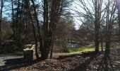

Diemeringen chalet Grunenwald

helmut68
User

Length
7.9 km

Max alt
329 m

Uphill gradient
176 m

Km-Effort
10.2 km

Min alt
234 m

Downhill gradient
172 m
Boucle
Yes
Creation date :
2019-05-06 15:04:49.417
Updated on :
2019-05-06 15:04:49.417
1h42
Difficulty : Easy

FREE GPS app for hiking
About
Trail Walking of 7.9 km to be discovered at Grand Est, Bas-Rhin, Diemeringen. This trail is proposed by helmut68.
Description
Départ Haut de Diemeringen,passer devant l'étang puis prendre à droite le chemin du petit Grünewald jusqu'au chalet . Puis retour par la route forestière du grand Grünewald .
Pratiquable toute l'année . A vos chaussures...
Positioning
Country:
France
Region :
Grand Est
Department/Province :
Bas-Rhin
Municipality :
Diemeringen
Location:
Unknown
Start:(Dec)
Start:(UTM)
367832 ; 5421982 (32U) N.
Comments
Trails nearby
Mackwiller la romaine


On foot
Easy
Diemeringen,
Grand Est,
Bas-Rhin,
France

4.6 km | 5.4 km-effort
1h 14min
Yes
Croix bleue


On foot
Easy
Diemeringen,
Grand Est,
Bas-Rhin,
France

12.3 km | 16.1 km-effort
3h 39min
No

Mémoire de pierres et d'eau


On foot
Easy
Berg,
Grand Est,
Bas-Rhin,
France

3.3 km | 3.8 km-effort
51min
No

Triangle bleu


On foot
Easy
Diemeringen,
Grand Est,
Bas-Rhin,
France

7.6 km | 9.6 km-effort
2h 10min
No
Comtesse Sophie de Nassau


On foot
Easy
Diemeringen,
Grand Est,
Bas-Rhin,
France

6.9 km | 8.1 km-effort
1h 50min
Yes

Yellow triangle


On foot
Medium
Diemeringen,
Grand Est,
Bas-Rhin,
France

21 km | 27 km-effort
6h 11min
No
2024-04-07 Les vergers de Butten


sport
Very easy
Butten,
Grand Est,
Bas-Rhin,
France

4.3 km | 5.5 km-effort
Unknown
Yes
Chevalet vert


On foot
Easy
Ratzwiller,
Grand Est,
Bas-Rhin,
France

6.1 km | 8.2 km-effort
1h 51min
No

Boucle Adamswiller Kirschberg


Horseback riding
Medium
Adamswiller,
Grand Est,
Bas-Rhin,
France

24 km | 30 km-effort
3h 53min
Yes


 SityTrail


