Trail Cycle Villotte-devant-Louppy - Découverte de la campagne Meusienne - Villotte-devant-Louppy - Photo

Découverte de la campagne Meusienne - Villotte-devant-Louppy

 tracegps
tracegps

User

© OpenStreetMap contributors
Length
Length
16.2 km
Max alt
Max alt
246 m
Uphill gradient
Uphill gradient
162 m
Km-Effort
Km-Effort  
18.4 km
Min alt
Min alt
188 m
Downhill gradient
Downhill gradient
161 m
Boucle
Boucle
Yes
Creation date :
2014-12-10 00:00:00.0
Updated on :
2014-12-10 00:00:00.0

(0 Reviews)

Cycle
Cycle
1h30
Difficulty : Medium

Scan this QR Code to open this trail in the SityTrail application

FREE GPS app for hiking

Logo SityTrail SityTrail

IGN / Geographical institutes

Download SityTrail from the App Store Download SityTrail from Google Play

Logo SityTrail SityTrail World

The world is yours!

Download SityTrail from the App Store Download SityTrail from Google Play Download SityTrail on Huawei AppGallery

About

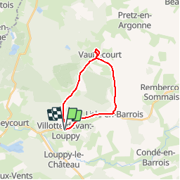
Trail Cycle of 16.2 km to be discovered at Grand Est, Meuse, Villotte-devant-Louppy. This trail is proposed by tracegps.

Description

Circuit proposé par la Communauté de Communes Triaucourt-Vaubecourt. Départ du gîte de Villotte-devant-Louppy. Retrouvez cette randonnée sur le site de la la Communauté de Communes Triaucourt-Vaubecourt. Ce circuit a été numérisé par les randonneurs du CODEPEM. Merci à Jean-Marie.

Elevation profile

Photos

Positioning

Country:
France
Region :
Grand Est
Department/Province :
Meuse
Municipality :
Villotte-devant-Louppy
Location:
Unknown
Start:(UTM)
652357 ; 5416812 (31U) N.

Trails nearby

Trail Walking Laheycourt - La boucle du chêne Henriot - Laheycourt - Photo
Walking
tracegps

Walking

Difficult
Laheycourt, Grand Est, Meuse, France
15.8 km | 18.1 km-effort
4h 0min
Yes
Trail Walking Villers-aux-Vents - La boucle d'Eole - Villers-aux-Vents - Photo
Walking
tracegps

Walking

Medium
Villers-aux-Vents, Grand Est, Meuse, France
7.9 km | 8.9 km-effort
2h 0min
Yes
Trail Other activity Laheycourt - Entre Meuse et Marne - Photo
Other activity
Antoine55800

Other activity

Easy
Laheycourt, Grand Est, Meuse, France
29 km | 33 km-effort
2h 20min
No
Trail Horseback riding Vaubecourt - vaub/chardogne - Photo
Horseback riding
delphd

Horseback riding

Easy
(1)
Vaubecourt, Grand Est, Meuse, France
16.6 km | 19.7 km-effort
2h 35min
No
Trail Horseback riding Vaubecourt - vaub/conde/chardogne - Photo
Horseback riding
delphd

Horseback riding

Medium
Vaubecourt, Grand Est, Meuse, France
22 km | 26 km-effort
3h 25min
No
Trail Horseback riding Vaubecourt - vaub/louppy/conde/chardogne - Photo
Horseback riding
delphd

Horseback riding

Medium
Vaubecourt, Grand Est, Meuse, France
18.1 km | 21 km-effort
2h 46min
No


Close
My subscriptions