Trail Walking Lauzun - Lauzun, la boucle des églises de St-Macaire, Queyssel et St-Nazaire - Pays du Dropt - Photo

Lauzun, la boucle des églises de St-Macaire, Queyssel et St-Nazaire - Pays du Dropt

 tracegps
tracegps

User

© OpenStreetMap contributors
Length
Length
14 km
Max alt
Max alt
121 m
Uphill gradient
Uphill gradient
161 m
Km-Effort
Km-Effort  
16.2 km
Min alt
Min alt
58 m
Downhill gradient
Downhill gradient
158 m
Boucle
Boucle
Yes
Creation date :
2014-12-10 00:00:00.0
Updated on :
2014-12-10 00:00:00.0

(0 Reviews)

Walking
Walking
3h40
Difficulty : Medium

Scan this QR Code to open this trail in the SityTrail application

FREE GPS app for hiking

Logo SityTrail SityTrail

IGN / Geographical institutes

Download SityTrail from the App Store Download SityTrail from Google Play

Logo SityTrail SityTrail World

The world is yours!

Download SityTrail from the App Store Download SityTrail from Google Play Download SityTrail on Huawei AppGallery

About

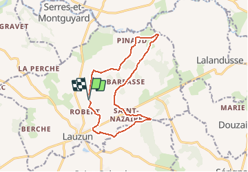
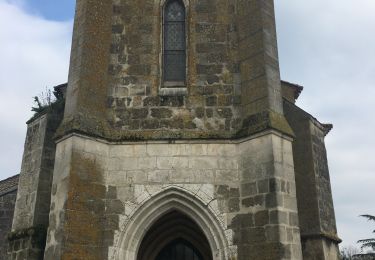
Trail Walking of 14 km to be discovered at New Aquitaine, Lot-et-Garonne, Lauzun. This trail is proposed by tracegps.

Description

St Macaire / St Nazaire commune de Lauzun C. C. du Pays de Lauzun. Trois églises bornent cet itinéraire tracé dans la vallée du Dropt. Les passages sur des petites routes sont assez nombreux, alternant avec de larges pistes en terre, ombragées. Téléchargez la fiche de cette randonnée sur le site du Tourisme du Lot et Garonne.

Elevation profile

Photos

Positioning

Country:
France
Region :
New Aquitaine
Department/Province :
Lot-et-Garonne
Municipality :
Lauzun
Location:
Unknown
Start:(UTM)
299041 ; 4946360 (31T) N.

Trails nearby

Trail Road bike Lauzun - boucle 60 km - Photo
Road bike
Melifera

Road bike

Medium
(1)
Lauzun, New Aquitaine, Lot-et-Garonne, France
60 km | 72 km-effort
2h 21min
Yes
Trail Road bike Lauzun - Boucle Lauzun 66 km - Photo
Road bike
Melifera

Road bike

Very difficult
(1)
Lauzun, New Aquitaine, Lot-et-Garonne, France
66 km | 78 km-effort
4h 45min
Yes
Trail Mountain bike Ségalas - Les Graoussettes, un lac d'irrigation et de loisirs - Ségalas - Photo
Mountain bike
tracegps

Mountain bike

Easy
Ségalas, New Aquitaine, Lot-et-Garonne, France
6.3 km | 7.3 km-effort
45min
Yes
Trail Walking Ségalas - Les Graoussettes, un lac d'irrigation et de loisirs - Ségalas - Photo
Walking
tracegps

Walking

Easy
Ségalas, New Aquitaine, Lot-et-Garonne, France
6.3 km | 7.3 km-effort
2h 10min
Yes
Trail Equestrian Lauzun - De Lauzun à Minerve - Photo
Equestrian
tracegps

Equestrian

Difficult
Lauzun, New Aquitaine, Lot-et-Garonne, France
18.8 km | 22 km-effort
3h 10min
Yes
Trail Mountain bike Lauzun - De Lauzun à Minerve - Photo
Mountain bike
tracegps

Mountain bike

Medium
Lauzun, New Aquitaine, Lot-et-Garonne, France
18.8 km | 22 km-effort
2h 19min
Yes
Trail Walking Lauzun - De Lauzun à Minerve - Photo
Walking
tracegps

Walking

Difficult
Lauzun, New Aquitaine, Lot-et-Garonne, France
18.8 km | 22 km-effort
4h 49min
Yes
Trail Walking Lauzun - Lauzun 01042021 - Photo
Walking
Roulland

Walking

Very easy
Lauzun, New Aquitaine, Lot-et-Garonne, France
7.6 km | 9.1 km-effort
2h 2min
Yes
Trail Walking Bourgougnague - Bourgougnague 2 - Photo
Walking
Briarwood

Walking

Easy
Bourgougnague, New Aquitaine, Lot-et-Garonne, France
49 km | 55 km-effort
1h 45min
No


Close
My subscriptions