![](/images/other/stat-length.png)
![Trail Equestrian Laplume - Laplume, circuit des lacs et lavoirs dans les coteaux de Gascogne - Pays de l'Agenais - Photo](https://media.geolcdn.com/t/1900/400/ext.pjpeg?maxdim=2&url=https%3A%2F%2Fservices.sitytrail.com%2FGeolivesWS%2FDownloadMedia.ashx%3FTrailID%3D110632%26Media%3D6204_1.jpg)
Laplume, circuit des lacs et lavoirs dans les coteaux de Gascogne - Pays de l'Agenais
tracegps
User
![Length](/images/other/stat-length.png)
![Max alt](https://static1.geolcdn.com/siteimages/upload/files/1508320355ic_sort_altitude_max_24dp.png)
![Uphill gradient](https://static1.geolcdn.com/siteimages/upload/files/1508320355ic_sort_den_pos_24dp.png)
![Km-Effort](/images/other/stat-length.png)
![Min alt](https://static1.geolcdn.com/siteimages/upload/files/1508320355ic_sort_altitude_min_24dp.png)
![Downhill gradient](https://static1.geolcdn.com/siteimages/upload/files/1508320355ic_sort_den_neg_24dp.png)
![Boucle](https://static1.geolcdn.com/siteimages/upload/files/16400158638029165_repeat_loop_refresh_sync_direction_icon.png)
![Equestrian](https://static1.geolcdn.com/sitytour/trail-icons/300.png)
3h15
Difficulty : Difficult
![Scan this QR Code to open this trail in the SityTrail application](https://capi.geolives.com/qq0zvz2zws4bq2lad0pu/sitytour/trails/110632/qr.png?size=200)
FREE GPS app for hiking
About
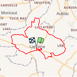
Trail Equestrian of 18.8 km to be discovered at New Aquitaine, Lot-et-Garonne, Laplume. This trail is proposed by tracegps.
Description
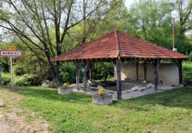
Laplume / Magnan Cté Com. du Canton de Laplume en Bruilhois. Long parcours accidenté, parsemé de nombreuses retenues d’eau, qui offre plusieurs points de vue sur les coteaux de Gascogne alentours, avec ses villages promontoires tels que Montagnac-sur-Auvignon, Moncaut.. Téléchargez la fiche de cette randonnée sur le site du Tourisme du Lot et Garonne.
Positioning
Comments
Trails nearby
![Trail On foot Saint-Vincent-de-Lamontjoie - Saint-Vincent-de-Lamontjoie, balade vers le lac de Lambronne variante 8 km - Photo](https://media.geolcdn.com/t/375/260/65291312-7a13-4e28-81f9-283781c16970.jpeg&format=jpg&maxdim=2)
![On foot On foot](https://static1.geolcdn.com/sitytour/trail-icons/100.png)
On foot
![](/images/other/stat-length.png)
![](https://static1.geolcdn.com/siteimages/upload/files/16400158638029165_repeat_loop_refresh_sync_direction_icon.png)
![Trail On foot Lamontjoie - Lamontjoie, bastide de Gascogne 7.8 km - Photo](https://media.geolcdn.com/t/375/260/59fb9cf4-5bec-49cb-aad6-f0ed83517ecf.jpeg&format=jpg&maxdim=2)
![On foot On foot](https://static1.geolcdn.com/sitytour/trail-icons/100.png)
On foot
![](/images/other/stat-length.png)
![](https://static1.geolcdn.com/siteimages/upload/files/16400158638029165_repeat_loop_refresh_sync_direction_icon.png)
![Trail Walking Nomdieu - le Nomdieu à la découverte des cadrans solaires - Photo](https://media.geolcdn.com/t/375/260/f04d7cc9-3b4c-4a60-8454-f740eac0d5c6.jpg&format=jpg&maxdim=2)
![Walking Walking](https://static1.geolcdn.com/sitytour/trail-icons/101.png)
Walking
![](/images/other/stat-length.png)
![](https://static1.geolcdn.com/siteimages/upload/files/16400158638029165_repeat_loop_refresh_sync_direction_icon.png)
![Trail On foot Nomdieu - Le Nomdieu, vers le point de vue de l'église de Saint-Lary 8.9 km - Photo](https://media.geolcdn.com/t/375/260/5bb70d90-4b4a-43ed-83a4-640fd202f525.jpeg&format=jpg&maxdim=2)
![On foot On foot](https://static1.geolcdn.com/sitytour/trail-icons/100.png)
On foot
![](/images/other/stat-length.png)
![](https://static1.geolcdn.com/siteimages/upload/files/16400158638029165_repeat_loop_refresh_sync_direction_icon.png)
![Trail On foot Nomdieu - Le Nomdieu, vers le point de vue de l'église de Saint-Lary variante 7.9 km - Photo](https://media.geolcdn.com/t/375/260/5bb70d90-4b4a-43ed-83a4-640fd202f525.jpeg&format=jpg&maxdim=2)
![On foot On foot](https://static1.geolcdn.com/sitytour/trail-icons/100.png)
On foot
![](/images/other/stat-length.png)
![](https://static1.geolcdn.com/siteimages/upload/files/16400158638029165_repeat_loop_refresh_sync_direction_icon.png)
![Trail On foot Nomdieu - Le Nomdieu, vers le point de vue de l'église de Saint-Lary variante 3.7 km - Photo](https://media.geolcdn.com/t/375/260/5bb70d90-4b4a-43ed-83a4-640fd202f525.jpeg&format=jpg&maxdim=2)
![On foot On foot](https://static1.geolcdn.com/sitytour/trail-icons/100.png)
On foot
![](/images/other/stat-length.png)
![](https://static1.geolcdn.com/siteimages/upload/files/16400158638029165_repeat_loop_refresh_sync_direction_icon.png)
![Trail On foot Nomdieu - Le Nomdieu, à la découverte des cadrans solaires 13.9 km - Photo](https://media.geolcdn.com/t/375/260/5bb70d90-4b4a-43ed-83a4-640fd202f525.jpeg&format=jpg&maxdim=2)
![On foot On foot](https://static1.geolcdn.com/sitytour/trail-icons/100.png)
On foot
![](/images/other/stat-length.png)
![](https://static1.geolcdn.com/siteimages/upload/files/16400158638029165_repeat_loop_refresh_sync_direction_icon.png)
![Trail Equestrian Nomdieu - Le Nomdieu vers le point de vue de l'église de St-Lary - Photo](https://media.geolcdn.com/t/375/260/ext.jpg?maxdim=2&url=https%3A%2F%2Fservices.sitytrail.com%2FGeolivesWS%2FDownloadMedia.ashx%3FTrailID%3D317332%26Media%3D16537_3.jpg)
![Equestrian Equestrian](https://static1.geolcdn.com/sitytour/trail-icons/300.png)
Equestrian
![](/images/other/stat-length.png)
![](https://static1.geolcdn.com/siteimages/upload/files/16400158638029165_repeat_loop_refresh_sync_direction_icon.png)
![Trail Mountain bike Nomdieu - Le Nomdieu vers le point de vue de l'église de St-Lary - Photo](https://media.geolcdn.com/t/375/260/ext.jpg?maxdim=2&url=https%3A%2F%2Fservices.sitytrail.com%2FGeolivesWS%2FDownloadMedia.ashx%3FTrailID%3D317331%26Media%3D16537_1.jpg)
![Mountain bike Mountain bike](https://static1.geolcdn.com/sitytour/trail-icons/202.png)
Mountain bike
![](/images/other/stat-length.png)
![](https://static1.geolcdn.com/siteimages/upload/files/16400158638029165_repeat_loop_refresh_sync_direction_icon.png)