Trail Mountain bike Engayrac - Engayrac, une randonnée dans la vallée de Gandaille - Pays de l'Agenais - Photo

Engayrac, une randonnée dans la vallée de Gandaille - Pays de l'Agenais

 tracegps
tracegps

User

© OpenStreetMap contributors
Length
Length
10.5 km
Max alt
Max alt
226 m
Uphill gradient
Uphill gradient
207 m
Km-Effort
Km-Effort  
13.2 km
Min alt
Min alt
141 m
Downhill gradient
Downhill gradient
207 m
Boucle
Boucle
Yes
Creation date :
2014-12-10 00:00:00.0
Updated on :
2014-12-10 00:00:00.0

(0 Reviews)

Mountain bike
Mountain bike
1h19
Difficulty : Medium

Scan this QR Code to open this trail in the SityTrail application

FREE GPS app for hiking

Logo SityTrail SityTrail

IGN / Geographical institutes

Download SityTrail from the App Store Download SityTrail from Google Play

Logo SityTrail SityTrail World

The world is yours!

Download SityTrail from the App Store Download SityTrail from Google Play Download SityTrail on Huawei AppGallery

About

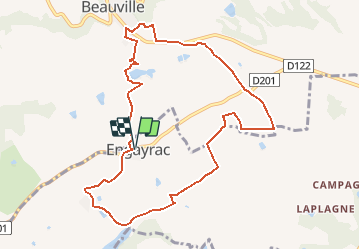
Trail Mountain bike of 10.5 km to be discovered at New Aquitaine, Lot-et-Garonne, Engayrac. This trail is proposed by tracegps.

Description

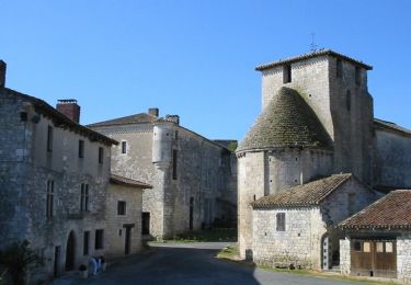
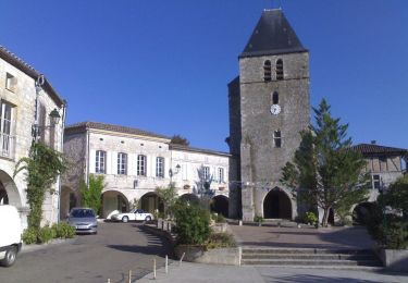
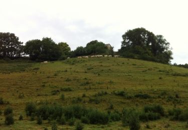
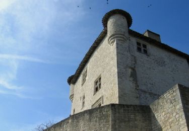
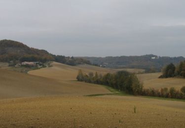
Engayrac Communauté de Communes des Coteaux de Beauville. Après le château de Combebonnet, ce circuit passe en amont du lac de Gandaille, traverse un grand plateau où céréales et cultures maraîchères sont très présentes, et se termine sur les chemins escarpés qui entourent le lac touristique de Beauville. Téléchargez la fiche de cette randonnée sur le site du Tourisme du Lot et Garonne.

Elevation profile

Photos

Positioning

Country:
France
Region :
New Aquitaine
Department/Province :
Lot-et-Garonne
Municipality :
Engayrac
Location:
Unknown
Start:(UTM)
331254 ; 4902812 (31T) N.

Trails nearby

Trail Equestrian Beauville - Beauville, Frespech, d'un promontoire fortifié à l'autre - Photo
Equestrian
tracegps

Equestrian

Medium
Beauville, New Aquitaine, Lot-et-Garonne, France
16.3 km | 24 km-effort
2h 49min
Yes
Trail Mountain bike Beauville - Beauville, Frespech, d'un promontoire fortifié à l'autre - Photo
Mountain bike
tracegps

Mountain bike

Medium
Beauville, New Aquitaine, Lot-et-Garonne, France
16.3 km | 24 km-effort
2h 10min
Yes
Trail Walking Beauville - Beauville, Frespech, d'un promontoire fortifié à l'autre - Photo
Walking
tracegps

Walking

Difficult
Beauville, New Aquitaine, Lot-et-Garonne, France
16.3 km | 24 km-effort
4h 30min
Yes
Trail Mountain bike Engayrac - Les coteaux d'Engayrac - Photo
Mountain bike
tracegps

Mountain bike

Difficult
Engayrac, New Aquitaine, Lot-et-Garonne, France
17.6 km | 24 km-effort
1h 30min
Yes
Trail Walking Engayrac - Les coteaux d'Engayrac - Photo
Walking
tracegps

Walking

Difficult
Engayrac, New Aquitaine, Lot-et-Garonne, France
17.6 km | 24 km-effort
3h 30min
Yes
Trail Mountain bike Engayrac - La Déjantée 2012 - Engayrac - Photo
Mountain bike
tracegps

Mountain bike

Difficult
Engayrac, New Aquitaine, Lot-et-Garonne, France
38 km | 52 km-effort
2h 30min
Yes
Trail Equestrian Engayrac - Engayrac, une randonnée dans la vallée de Gandaille - Pays de l'Agenais - Photo
Equestrian
tracegps

Equestrian

Medium
Engayrac, New Aquitaine, Lot-et-Garonne, France
10.5 km | 13.2 km-effort
1h 45min
Yes
Trail Walking Engayrac - Engayrac, une randonnée dans la vallée de Gandaille - Pays de l'Agenais - Photo
Walking
tracegps

Walking

Medium
Engayrac, New Aquitaine, Lot-et-Garonne, France
10.5 km | 13.2 km-effort
2h 45min
Yes
Trail Equestrian Dondas - Dondas, balade dans les coteaux du Pays de Serres - Pays de l'Agenais - Photo
Equestrian
tracegps

Equestrian

Difficult
Dondas, New Aquitaine, Lot-et-Garonne, France
14.1 km | 19.1 km-effort
2h 19min
Yes


Close
My subscriptions