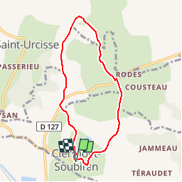
![](/images/other/stat-length.png)
![Trail Walking Clermont-Soubiran - Clermont-Soubiran, vers la chapelle d'Aureillac - Pays de l'Agenais - Photo](https://media.geolcdn.com/t/1900/400/ext.pjpeg?maxdim=2&url=https%3A%2F%2Fservices.sitytrail.com%2FGeolivesWS%2FDownloadMedia.ashx%3FTrailID%3D110596%26Media%3D6134_1.jpg)
Clermont-Soubiran, vers la chapelle d'Aureillac - Pays de l'Agenais
tracegps
User
![Length](/images/other/stat-length.png)
![Max alt](https://static1.geolcdn.com/siteimages/upload/files/1508320355ic_sort_altitude_max_24dp.png)
![Uphill gradient](https://static1.geolcdn.com/siteimages/upload/files/1508320355ic_sort_den_pos_24dp.png)
![Km-Effort](/images/other/stat-length.png)
![Min alt](https://static1.geolcdn.com/siteimages/upload/files/1508320355ic_sort_altitude_min_24dp.png)
![Downhill gradient](https://static1.geolcdn.com/siteimages/upload/files/1508320355ic_sort_den_neg_24dp.png)
![Boucle](https://static1.geolcdn.com/siteimages/upload/files/16400158638029165_repeat_loop_refresh_sync_direction_icon.png)
![Walking](https://static1.geolcdn.com/sitytour/trail-icons/101.png)
1h49
Difficulty : Medium
![Scan this QR Code to open this trail in the SityTrail application](https://capi.geolives.com/qq0zvz2zws4bq2lad0pu/sitytour/trails/110596/qr.png?size=200)
FREE GPS app for hiking
About
Trail Walking of 7 km to be discovered at New Aquitaine, Lot-et-Garonne, Clermont-Soubiran. This trail is proposed by tracegps.
Description
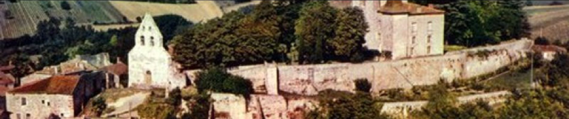
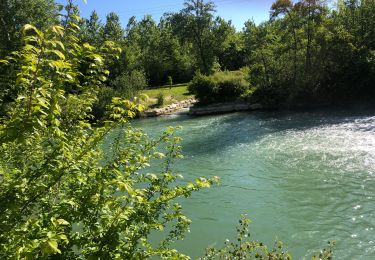
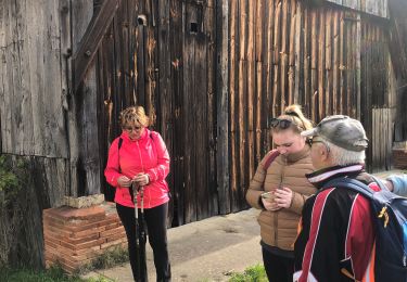
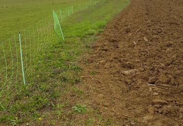
Clermont Soubiran / Aureillac Cté de Communes des Deux Séounes. Ce circuit court mais physique, par endroits, offre de nombreux points de vue sur les coteaux du Pays de Serres, la vallée de la Garonne et les ondulations des coteaux de Gascogne à l’horizon. La chapelle d’Aureillac, mérite l’attention, même si elle ne peut se découvrir que de l’extérieur. Téléchargez la fiche de cette randonnée sur le site du Tourisme du Lot et Garonne.
Positioning
Comments
Trails nearby
![Trail sport Valence - 08/07/2024 - Photo](https://media.geolcdn.com/t/375/260/02acc9ee-7c4c-41fe-bef4-167218db40e8.jpg&format=jpg&maxdim=2)
sport
![](/images/other/stat-length.png)
![](https://static1.geolcdn.com/siteimages/upload/files/16400158638029165_repeat_loop_refresh_sync_direction_icon.png)
![Trail sport Valence - 05/07/2024 - Photo](https://media.geolcdn.com/t/375/260/84bb87fd-d366-464e-b431-244375a9f25d.jpg&format=jpg&maxdim=2)
sport
![](/images/other/stat-length.png)
![](https://static1.geolcdn.com/siteimages/upload/files/16400158638029165_repeat_loop_refresh_sync_direction_icon.png)
![Trail sport Valence - Ballade 29/06/24 - Photo](https://media.geolcdn.com/t/375/260/74cd2fc9-f021-476e-b08b-146858c09e5c.jpg&format=jpg&maxdim=2)
sport
![](/images/other/stat-length.png)
![](https://static1.geolcdn.com/siteimages/upload/files/16400158638029165_repeat_loop_refresh_sync_direction_icon.png)
![Trail sport Valence - Lundi 22avril 2024 - Photo](https://media.geolcdn.com/t/375/260/aa7242f5-a0f4-4f88-9610-5938dbe858ee.jpg&format=jpg&maxdim=2)
sport
![](/images/other/stat-length.png)
![](https://static1.geolcdn.com/siteimages/upload/files/16400158638029165_repeat_loop_refresh_sync_direction_icon.png)
![Trail sport Valence - Les marcheurs du Pontus 18 avril 2024 - Photo](https://media.geolcdn.com/t/375/260/462dfb00-e608-49e4-92cf-bae19c6c9ef9.jpg&format=jpg&maxdim=2)
sport
![](/images/other/stat-length.png)
![](https://static1.geolcdn.com/siteimages/upload/files/16400158638029165_repeat_loop_refresh_sync_direction_icon.png)
![Trail Walking Clermont-Soubiran - Coteaux depuis maison Roiatti - Photo](https://media.geolcdn.com/t/375/260/00d8c168-eeb7-45cf-a950-8b81643238bd.jpg&format=jpg&maxdim=2)
![Walking Walking](https://static1.geolcdn.com/sitytour/trail-icons/101.png)
Walking
![](/images/other/stat-length.png)
![](https://static1.geolcdn.com/siteimages/upload/files/16400158638029165_repeat_loop_refresh_sync_direction_icon.png)
![Trail Walking Clermont-Soubiran - coupet autour de labro - Photo](https://media.geolcdn.com/t/375/260/ext.jpg?maxdim=2&url=https%3A%2F%2Fstatic1.geolcdn.com%2Fsiteimages%2Fupload%2Ffiles%2F1553511878bg_sport_marche.png)
![Walking Walking](https://static1.geolcdn.com/sitytour/trail-icons/101.png)
Walking
![](/images/other/stat-length.png)
![](https://static1.geolcdn.com/siteimages/upload/files/16400158638029165_repeat_loop_refresh_sync_direction_icon.png)
![Trail Mountain bike Donzac - Les sentiers du Brulhois - Donzac - Photo](https://media.geolcdn.com/t/375/260/ext.jpg?maxdim=2&url=https%3A%2F%2Fservices.sitytrail.com%2FGeolivesWS%2FDownloadMedia.ashx%3FTrailID%3D106609%26Media%3D11209_1.jpg)
![Mountain bike Mountain bike](https://static1.geolcdn.com/sitytour/trail-icons/202.png)
Mountain bike
![](/images/other/stat-length.png)
![](https://static1.geolcdn.com/siteimages/upload/files/16400158638029165_repeat_loop_refresh_sync_direction_icon.png)
![Trail Mountain bike Saint-Romain-le-Noble - St Romain le Noble / St Pierre de Clairac / Puymirol - Photo](https://media.geolcdn.com/t/375/260/ext.jpg?maxdim=2&url=https%3A%2F%2Fservices.sitytrail.com%2FGeolivesWS%2FDownloadMedia.ashx%3FTrailID%3D101505%26Media%3D1611_4.jpg)
![Mountain bike Mountain bike](https://static1.geolcdn.com/sitytour/trail-icons/202.png)
Mountain bike
![](/images/other/stat-length.png)
![](https://static1.geolcdn.com/siteimages/upload/files/16400158638029165_repeat_loop_refresh_sync_direction_icon.png)