![](/images/other/stat-length.png)
![Trail Cycle Quittebeuf - Boucle des coteaux - Quittebeuf - Photo](https://media.geolcdn.com/t/1900/400/ext.pjpeg?maxdim=2&url=https%3A%2F%2Fstatic1.geolcdn.com%2Fsiteimages%2Fupload%2Ffiles%2F1524743154velo.jpg)
Boucle des coteaux - Quittebeuf
tracegps
User
![Length](/images/other/stat-length.png)
Length
34 km
![Max alt](https://static1.geolcdn.com/siteimages/upload/files/1508320355ic_sort_altitude_max_24dp.png)
Max alt
159 m
![Uphill gradient](https://static1.geolcdn.com/siteimages/upload/files/1508320355ic_sort_den_pos_24dp.png)
Uphill gradient
257 m
![Km-Effort](/images/other/stat-length.png)
Km-Effort
37 km
![Min alt](https://static1.geolcdn.com/siteimages/upload/files/1508320355ic_sort_altitude_min_24dp.png)
Min alt
74 m
![Downhill gradient](https://static1.geolcdn.com/siteimages/upload/files/1508320355ic_sort_den_neg_24dp.png)
Downhill gradient
257 m
![Boucle](https://static1.geolcdn.com/siteimages/upload/files/16400158638029165_repeat_loop_refresh_sync_direction_icon.png)
Boucle
Yes
Creation date :
2014-12-10 00:00:00.0
Updated on :
2014-12-10 00:00:00.0
![Cycle](https://static1.geolcdn.com/sitytour/trail-icons/200.png)
1h40
Difficulty : Medium
![Scan this QR Code to open this trail in the SityTrail application](https://capi.geolives.com/qq0zvz2zws4bq2lad0pu/sitytour/trails/110517/qr.png?size=200)
FREE GPS app for hiking
About
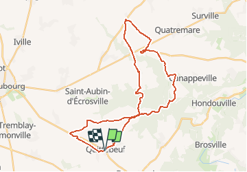
Trail Cycle of 34 km to be discovered at Normandy, Eure, Quittebeuf. This trail is proposed by tracegps.
Description
Circuit proposé par l’Office de Tourisme de Le Neubourg. Départ de l’église de Quittebeuf. Le dépliant reprenant l’ensemble des circuits est à votre disposition à l’Office du Tourisme. Ce circuit a été numérisé par les randonneurs du CODEPEM. Merci à Jean-Marie.
Positioning
Country:
France
Region :
Normandy
Department/Province :
Eure
Municipality :
Quittebeuf
Location:
Unknown
Start:(Dec)
Start:(UTM)
354748 ; 5441272 (31U) N.
Comments
Trails nearby
![Trail Walking Villettes - Villettes - Photo](https://media.geolcdn.com/t/375/260/b0f1a832-63f3-4465-9278-16a77fa15c4c.jpg&format=jpg&maxdim=2)
![Walking Walking](https://static1.geolcdn.com/sitytour/trail-icons/101.png)
![Trail Cycle Graveron-Sémerville - Boucle des vergers - Graveron-Sémerville - Photo](https://media.geolcdn.com/t/375/260/ext.jpg?maxdim=2&url=https%3A%2F%2Fservices.sitytrail.com%2FGeolivesWS%2FDownloadMedia.ashx%3FTrailID%3D110527%26Media%3D6069_1.jpg)
![Cycle Cycle](https://static1.geolcdn.com/sitytour/trail-icons/200.png)
Boucle des vergers - Graveron-Sémerville
Cycle
Easy
Graveron-Sémerville,
Normandy,
Eure,
France
![](/images/other/stat-length.png)
10.7 km | 11.4 km-effort
30min
![](https://static1.geolcdn.com/siteimages/upload/files/16400158638029165_repeat_loop_refresh_sync_direction_icon.png)
Yes
![Trail Cycle Quittebeuf - Boucle du Plateau - Quittebeuf - Photo](https://media.geolcdn.com/t/375/260/ext.jpg?maxdim=2&url=https%3A%2F%2Fstatic1.geolcdn.com%2Fsiteimages%2Fupload%2Ffiles%2F1524743154velo.jpg)
![Cycle Cycle](https://static1.geolcdn.com/sitytour/trail-icons/200.png)
Boucle du Plateau - Quittebeuf
Cycle
Medium
Quittebeuf,
Normandy,
Eure,
France
![](/images/other/stat-length.png)
42 km | 45 km-effort
2h 15min
![](https://static1.geolcdn.com/siteimages/upload/files/16400158638029165_repeat_loop_refresh_sync_direction_icon.png)
Yes
![Trail Cycle Bernienville - Boucle de la Closerie - Bernienville - Photo](https://media.geolcdn.com/t/375/260/ext.jpg?maxdim=2&url=https%3A%2F%2Fstatic1.geolcdn.com%2Fsiteimages%2Fupload%2Ffiles%2F1524743154velo.jpg)
![Cycle Cycle](https://static1.geolcdn.com/sitytour/trail-icons/200.png)
Boucle de la Closerie - Bernienville
Cycle
Easy
Bernienville,
Normandy,
Eure,
France
![](/images/other/stat-length.png)
12.8 km | 13.4 km-effort
45min
![](https://static1.geolcdn.com/siteimages/upload/files/16400158638029165_repeat_loop_refresh_sync_direction_icon.png)
Yes
![Trail Cycle Quittebeuf - Boucle de la Vallée - Quittebeuf - Photo](https://media.geolcdn.com/t/375/260/ext.jpg?maxdim=2&url=https%3A%2F%2Fstatic1.geolcdn.com%2Fsiteimages%2Fupload%2Ffiles%2F1524743154velo.jpg)
![Cycle Cycle](https://static1.geolcdn.com/sitytour/trail-icons/200.png)
Boucle de la Vallée - Quittebeuf
Cycle
Medium
Quittebeuf,
Normandy,
Eure,
France
![](/images/other/stat-length.png)
34 km | 38 km-effort
1h 45min
![](https://static1.geolcdn.com/siteimages/upload/files/16400158638029165_repeat_loop_refresh_sync_direction_icon.png)
Yes
![Trail Equestrian Feuguerolles - Rally Marbeuf 2012 - Photo](https://media.geolcdn.com/t/375/260/ext.jpg?maxdim=2&url=https%3A%2F%2Fstatic1.geolcdn.com%2Fsiteimages%2Fupload%2Ffiles%2F1524743154cheval.jpg)
![Equestrian Equestrian](https://static1.geolcdn.com/sitytour/trail-icons/300.png)
Rally Marbeuf 2012
Equestrian
Very easy
Feuguerolles,
Normandy,
Eure,
France
![](/images/other/stat-length.png)
9.1 km | 11 km-effort
Unknown
![](https://static1.geolcdn.com/siteimages/upload/files/16400158638029165_repeat_loop_refresh_sync_direction_icon.png)
Yes
![Trail Walking Saint-Aubin-d'Écrosville - ST AUBIN D'ECROSVILLE - Photo](https://media.geolcdn.com/t/375/260/ext.jpg?maxdim=2&url=https%3A%2F%2Fstatic1.geolcdn.com%2Fsiteimages%2Fupload%2Ffiles%2F1553511878bg_sport_marche.png)
![Walking Walking](https://static1.geolcdn.com/sitytour/trail-icons/101.png)
ST AUBIN D'ECROSVILLE
Walking
Difficult
Saint-Aubin-d'Écrosville,
Normandy,
Eure,
France
![](/images/other/stat-length.png)
11.5 km | 12.7 km-effort
2h 52min
![](https://static1.geolcdn.com/siteimages/upload/files/16400158638029165_repeat_loop_refresh_sync_direction_icon.png)
Yes
![Trail Walking Saint-Aubin-d'Écrosville - St aubin d écrevisse 29 10 2024 - Photo](https://media.geolcdn.com/t/375/260/ext.jpg?maxdim=2&url=https%3A%2F%2Fstatic1.geolcdn.com%2Fsiteimages%2Fupload%2Ffiles%2F1553511878bg_sport_marche.png)
![Walking Walking](https://static1.geolcdn.com/sitytour/trail-icons/101.png)
St aubin d écrevisse 29 10 2024
Walking
Difficult
Saint-Aubin-d'Écrosville,
Normandy,
Eure,
France
![](/images/other/stat-length.png)
13.2 km | 14.8 km-effort
3h 30min
![](https://static1.geolcdn.com/siteimages/upload/files/16400158638029165_repeat_loop_refresh_sync_direction_icon.png)
Yes
![Trail Walking Villettes - 2023_03_Villettes - Photo](https://media.geolcdn.com/t/375/260/ext.jpg?maxdim=2&url=https%3A%2F%2Fstatic1.geolcdn.com%2Fsiteimages%2Fupload%2Ffiles%2F1553511878bg_sport_marche.png)
![Walking Walking](https://static1.geolcdn.com/sitytour/trail-icons/101.png)
2023_03_Villettes
Walking
Difficult
(1)
Villettes,
Normandy,
Eure,
France
![](/images/other/stat-length.png)
11.9 km | 14.1 km-effort
2h 45min
![](https://static1.geolcdn.com/siteimages/upload/files/16400158638029165_repeat_loop_refresh_sync_direction_icon.png)
Yes