![](/images/other/stat-length.png)
![Trail Walking Bonnétable - Bonnétable - Fleurs ou légumes...13km - Photo](https://media.geolcdn.com/t/1900/400/ext.pjpeg?maxdim=2&url=https%3A%2F%2Fservices.sitytrail.com%2FGeolivesWS%2FDownloadMedia.ashx%3FTrailID%3D110454%26Media%3D5949_1.jpg)
Bonnétable - Fleurs ou légumes...13km
tracegps
User
![Length](/images/other/stat-length.png)
Length
12.6 km
![Max alt](https://static1.geolcdn.com/siteimages/upload/files/1508320355ic_sort_altitude_max_24dp.png)
Max alt
147 m
![Uphill gradient](https://static1.geolcdn.com/siteimages/upload/files/1508320355ic_sort_den_pos_24dp.png)
Uphill gradient
114 m
![Km-Effort](/images/other/stat-length.png)
Km-Effort
14.1 km
![Min alt](https://static1.geolcdn.com/siteimages/upload/files/1508320355ic_sort_altitude_min_24dp.png)
Min alt
96 m
![Downhill gradient](https://static1.geolcdn.com/siteimages/upload/files/1508320355ic_sort_den_neg_24dp.png)
Downhill gradient
116 m
![Boucle](https://static1.geolcdn.com/siteimages/upload/files/16400158638029165_repeat_loop_refresh_sync_direction_icon.png)
Boucle
Yes
Creation date :
2014-12-10 00:00:00.0
Updated on :
2014-12-10 00:00:00.0
![Walking](https://static1.geolcdn.com/sitytour/trail-icons/101.png)
2h10
Difficulty : Medium
![Scan this QR Code to open this trail in the SityTrail application](https://capi.geolives.com/qq0zvz2zws4bq2lad0pu/sitytour/trails/110454/qr.png?size=200)
FREE GPS app for hiking
About
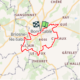
Trail Walking of 12.6 km to be discovered at Pays de la Loire, Sarthe, Bonnétable. This trail is proposed by tracegps.
Description
Bonnétable - Fleurs ou légumes…13km A la découverte des trésors cachés du Perche Sarthois. Variante ; après le chemin de « la Brancherie », prendre à gauche en direction du , passer par la « Petite Cannetière », ensuite le « chemin de Citeaux » et retour.
Positioning
Country:
France
Region :
Pays de la Loire
Department/Province :
Sarthe
Municipality :
Bonnétable
Location:
Unknown
Start:(Dec)
Start:(UTM)
308687 ; 5339147 (31U) N.
Comments
Trails nearby
![Trail Walking Bonnétable - la vive parence - Photo](https://media.geolcdn.com/t/375/260/ext.jpg?maxdim=2&url=https%3A%2F%2Fstatic1.geolcdn.com%2Fsiteimages%2Fupload%2Ffiles%2F1553511878bg_sport_marche.png)
![Walking Walking](https://static1.geolcdn.com/sitytour/trail-icons/101.png)
la vive parence
Walking
Easy
(1)
Bonnétable,
Pays de la Loire,
Sarthe,
France
![](/images/other/stat-length.png)
10 km | 11.5 km-effort
2h 36min
![](https://static1.geolcdn.com/siteimages/upload/files/16400158638029165_repeat_loop_refresh_sync_direction_icon.png)
Yes
![Trail Walking Bonnétable - Bonnétable - Fleurs ou légumes...15km - Photo](https://media.geolcdn.com/t/375/260/ext.jpg?maxdim=2&url=https%3A%2F%2Fservices.sitytrail.com%2FGeolivesWS%2FDownloadMedia.ashx%3FTrailID%3D110455%26Media%3D5950_1.jpg)
![Walking Walking](https://static1.geolcdn.com/sitytour/trail-icons/101.png)
Bonnétable - Fleurs ou légumes...15km
Walking
Medium
Bonnétable,
Pays de la Loire,
Sarthe,
France
![](/images/other/stat-length.png)
15.1 km | 17.5 km-effort
2h 30min
![](https://static1.geolcdn.com/siteimages/upload/files/16400158638029165_repeat_loop_refresh_sync_direction_icon.png)
Yes
![Trail Walking Bonnétable - Bonnétable - Fleurs ou légumes...18km - Photo](https://media.geolcdn.com/t/375/260/ext.jpg?maxdim=2&url=https%3A%2F%2Fservices.sitytrail.com%2FGeolivesWS%2FDownloadMedia.ashx%3FTrailID%3D110453%26Media%3D5948_1.jpg)
![Walking Walking](https://static1.geolcdn.com/sitytour/trail-icons/101.png)
Bonnétable - Fleurs ou légumes...18km
Walking
Medium
Bonnétable,
Pays de la Loire,
Sarthe,
France
![](/images/other/stat-length.png)
17.8 km | 20 km-effort
3h 0min
![](https://static1.geolcdn.com/siteimages/upload/files/16400158638029165_repeat_loop_refresh_sync_direction_icon.png)
Yes
![Trail Walking Torcé-en-Vallée - Butte de Montrentin depuis Torcé-en-Vallée - Photo](https://media.geolcdn.com/t/375/260/ext.jpg?maxdim=2&url=https%3A%2F%2Fstatic1.geolcdn.com%2Fsiteimages%2Fupload%2Ffiles%2F1553511878bg_sport_marche.png)
![Walking Walking](https://static1.geolcdn.com/sitytour/trail-icons/101.png)
Butte de Montrentin depuis Torcé-en-Vallée
Walking
Easy
Torcé-en-Vallée,
Pays de la Loire,
Sarthe,
France
![](/images/other/stat-length.png)
10.4 km | 11.6 km-effort
2h 38min
![](https://static1.geolcdn.com/siteimages/upload/files/16400158638029165_repeat_loop_refresh_sync_direction_icon.png)
Yes
![Trail Walking Briosne-lès-Sables - Briosne-lès-Sables - Photo](https://media.geolcdn.com/t/375/260/ext.jpg?maxdim=2&url=https%3A%2F%2Fstatic1.geolcdn.com%2Fsiteimages%2Fupload%2Ffiles%2F1553511878bg_sport_marche.png)
![Walking Walking](https://static1.geolcdn.com/sitytour/trail-icons/101.png)
Briosne-lès-Sables
Walking
Very easy
Briosne-lès-Sables,
Pays de la Loire,
Sarthe,
France
![](/images/other/stat-length.png)
12.4 km | 13.8 km-effort
2h 30min
![](https://static1.geolcdn.com/siteimages/upload/files/16400158638029165_repeat_loop_refresh_sync_direction_icon.png)
Yes
![Trail Mountain bike Beaufay - La Roger Legeay 2011 - Beaufay - Photo](https://media.geolcdn.com/t/375/260/ext.jpg?maxdim=2&url=https%3A%2F%2Fservices.sitytrail.com%2FGeolivesWS%2FDownloadMedia.ashx%3FTrailID%3D107662%26Media%3D12657_1.jpg)
![Mountain bike Mountain bike](https://static1.geolcdn.com/sitytour/trail-icons/202.png)
La Roger Legeay 2011 - Beaufay
Mountain bike
Medium
Beaufay,
Pays de la Loire,
Sarthe,
France
![](/images/other/stat-length.png)
36 km | 41 km-effort
2h 0min
![](https://static1.geolcdn.com/siteimages/upload/files/16400158638029165_repeat_loop_refresh_sync_direction_icon.png)
Yes
![Trail Walking Bonnétable - Bonnétable - Photo](https://media.geolcdn.com/t/375/260/ext.jpg?maxdim=2&url=https%3A%2F%2Fstatic1.geolcdn.com%2Fsiteimages%2Fupload%2Ffiles%2F1553511878bg_sport_marche.png)
![Walking Walking](https://static1.geolcdn.com/sitytour/trail-icons/101.png)
Bonnétable
Walking
Very easy
Bonnétable,
Pays de la Loire,
Sarthe,
France
![](/images/other/stat-length.png)
17.9 km | 21 km-effort
Unknown
![](https://static1.geolcdn.com/siteimages/upload/files/16400158638029165_repeat_loop_refresh_sync_direction_icon.png)
Yes
![Trail Nordic walking Prévelles - Tuffé réalisé - Photo](https://media.geolcdn.com/t/375/260/ext.jpg?maxdim=2&url=https%3A%2F%2Fstatic1.geolcdn.com%2Fsiteimages%2Fupload%2Ffiles%2F1545311037marcheuse_200dpi.jpg)
![Nordic walking Nordic walking](https://static1.geolcdn.com/sitytour/trail-icons/102.png)
Tuffé réalisé
Nordic walking
Easy
Prévelles,
Pays de la Loire,
Sarthe,
France
![](/images/other/stat-length.png)
6.7 km | 8 km-effort
2h 18min
![](https://static1.geolcdn.com/siteimages/upload/files/16400158638029165_repeat_loop_refresh_sync_direction_icon.png)
No
![Trail Walking Prévelles - Prévelles 150522 - Photo](https://media.geolcdn.com/t/375/260/ext.jpg?maxdim=2&url=https%3A%2F%2Fstatic1.geolcdn.com%2Fsiteimages%2Fupload%2Ffiles%2F1553511878bg_sport_marche.png)
![Walking Walking](https://static1.geolcdn.com/sitytour/trail-icons/101.png)
Prévelles 150522
Walking
Medium
Prévelles,
Pays de la Loire,
Sarthe,
France
![](/images/other/stat-length.png)
20 km | 24 km-effort
6h 8min
![](https://static1.geolcdn.com/siteimages/upload/files/16400158638029165_repeat_loop_refresh_sync_direction_icon.png)
Yes