![](/images/other/stat-length.png)
![Trail Walking Saint-Aubin - Saint Aubin - Circuit d'Albitus et de Bartel - Photo](https://media.geolcdn.com/t/1900/400/ext.pjpeg?maxdim=2&url=https%3A%2F%2Fservices.sitytrail.com%2FGeolivesWS%2FDownloadMedia.ashx%3FTrailID%3D110396%26Media%3D5852_1.jpg)
Saint Aubin - Circuit d'Albitus et de Bartel
tracegps
User
![Length](/images/other/stat-length.png)
Length
11.5 km
![Max alt](https://static1.geolcdn.com/siteimages/upload/files/1508320355ic_sort_altitude_max_24dp.png)
Max alt
138 m
![Uphill gradient](https://static1.geolcdn.com/siteimages/upload/files/1508320355ic_sort_den_pos_24dp.png)
Uphill gradient
230 m
![Km-Effort](/images/other/stat-length.png)
Km-Effort
14.6 km
![Min alt](https://static1.geolcdn.com/siteimages/upload/files/1508320355ic_sort_altitude_min_24dp.png)
Min alt
60 m
![Downhill gradient](https://static1.geolcdn.com/siteimages/upload/files/1508320355ic_sort_den_neg_24dp.png)
Downhill gradient
233 m
![Boucle](https://static1.geolcdn.com/siteimages/upload/files/16400158638029165_repeat_loop_refresh_sync_direction_icon.png)
Boucle
Yes
Creation date :
2014-12-10 00:00:00.0
Updated on :
2014-12-10 00:00:00.0
![Walking](https://static1.geolcdn.com/sitytour/trail-icons/101.png)
3h00
Difficulty : Difficult
![Scan this QR Code to open this trail in the SityTrail application](https://capi.geolives.com/qq0zvz2zws4bq2lad0pu/sitytour/trails/110396/qr.png?size=200)
FREE GPS app for hiking
About
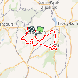
Trail Walking of 11.5 km to be discovered at Hauts-de-France, Aisne, Saint-Aubin. This trail is proposed by tracegps.
Description
A la croisée des vallées de l'Ailette et de l'Oise, ce circuit très contrasté alterne bois, plateau cultivé, beaux petits villages, sur un terrain assez vallonné. Retrouvez toutes les informations nécessaires ICI.
Positioning
Country:
France
Region :
Hauts-de-France
Department/Province :
Aisne
Municipality :
Saint-Aubin
Location:
Unknown
Start:(Dec)
Start:(UTM)
513740 ; 5483976 (31U) N.
Comments
Trails nearby
![Trail Walking Blérancourt - Blérancourt - Photo](https://media.geolcdn.com/t/375/260/ext.jpg?maxdim=2&url=https%3A%2F%2Fstatic1.geolcdn.com%2Fsiteimages%2Fupload%2Ffiles%2F1553511878bg_sport_marche.png)
![Walking Walking](https://static1.geolcdn.com/sitytour/trail-icons/101.png)
Blérancourt
Walking
Difficult
(1)
Blérancourt,
Hauts-de-France,
Aisne,
France
![](/images/other/stat-length.png)
14.1 km | 17.2 km-effort
3h 42min
![](https://static1.geolcdn.com/siteimages/upload/files/16400158638029165_repeat_loop_refresh_sync_direction_icon.png)
Yes
![Trail Walking Blérancourt - Sur les pas de Saint-Just - Photo](https://media.geolcdn.com/t/375/260/ext.jpg?maxdim=2&url=https%3A%2F%2Fservices.sitytrail.com%2FGeolivesWS%2FDownloadMedia.ashx%3FTrailID%3D108366%26Media%3D1042_1.jpg)
![Walking Walking](https://static1.geolcdn.com/sitytour/trail-icons/101.png)
Sur les pas de Saint-Just
Walking
Medium
Blérancourt,
Hauts-de-France,
Aisne,
France
![](/images/other/stat-length.png)
8.3 km | 10.2 km-effort
2h 0min
![](https://static1.geolcdn.com/siteimages/upload/files/16400158638029165_repeat_loop_refresh_sync_direction_icon.png)
Yes
![Trail Walking Saint-Aubin - Saint-Aubin - Photo](https://media.geolcdn.com/t/375/260/ext.jpg?maxdim=2&url=https%3A%2F%2Fstatic1.geolcdn.com%2Fsiteimages%2Fupload%2Ffiles%2F1553511878bg_sport_marche.png)
![Walking Walking](https://static1.geolcdn.com/sitytour/trail-icons/101.png)
Saint-Aubin
Walking
Difficult
(1)
Saint-Aubin,
Hauts-de-France,
Aisne,
France
![](/images/other/stat-length.png)
10.4 km | 13 km-effort
2h 58min
![](https://static1.geolcdn.com/siteimages/upload/files/16400158638029165_repeat_loop_refresh_sync_direction_icon.png)
Yes
![Trail sport Blérancourt - Pierrette - Photo](https://media.geolcdn.com/t/375/260/ext.jpg?maxdim=2&url=https%3A%2F%2Fsecurestorage.geolives.com%2Fsitytour%2Ftrail-bg%2Fdefault.jpg)
Pierrette
sport
Very easy
Blérancourt,
Hauts-de-France,
Aisne,
France
![](/images/other/stat-length.png)
12 km | 14.2 km-effort
Unknown
![](https://static1.geolcdn.com/siteimages/upload/files/16400158638029165_repeat_loop_refresh_sync_direction_icon.png)
Yes
![Trail On foot Vassens - Autour de Vassens 02 - Photo](https://media.geolcdn.com/t/375/260/ext.jpg?maxdim=2&url=https%3A%2F%2Fstatic1.geolcdn.com%2Fsiteimages%2Fupload%2Ffiles%2F1545311037marcheuse_200dpi.jpg)
![On foot On foot](https://static1.geolcdn.com/sitytour/trail-icons/100.png)
Autour de Vassens 02
On foot
Easy
Vassens,
Hauts-de-France,
Aisne,
France
![](/images/other/stat-length.png)
10.3 km | 12.4 km-effort
2h 48min
![](https://static1.geolcdn.com/siteimages/upload/files/16400158638029165_repeat_loop_refresh_sync_direction_icon.png)
Yes
![Trail Walking Blérancourt - Sur les pas de ST just - Photo](https://media.geolcdn.com/t/375/260/ext.jpg?maxdim=2&url=https%3A%2F%2Fstatic1.geolcdn.com%2Fsiteimages%2Fupload%2Ffiles%2F1553511878bg_sport_marche.png)
![Walking Walking](https://static1.geolcdn.com/sitytour/trail-icons/101.png)
Sur les pas de ST just
Walking
Difficult
Blérancourt,
Hauts-de-France,
Aisne,
France
![](/images/other/stat-length.png)
10.5 km | 12.6 km-effort
2h 51min
![](https://static1.geolcdn.com/siteimages/upload/files/16400158638029165_repeat_loop_refresh_sync_direction_icon.png)
Yes