Trail Walking Chassemy - Chassemy - Le temps perdu - Photo

Chassemy - Le temps perdu

 tracegps
tracegps

User

© OpenStreetMap contributors
Length
Length
14.3 km
Max alt
Max alt
163 m
Uphill gradient
Uphill gradient
236 m
Km-Effort
Km-Effort  
17.5 km
Min alt
Min alt
49 m
Downhill gradient
Downhill gradient
239 m
Boucle
Boucle
Yes
Creation date :
2014-12-10 00:00:00.0
Updated on :
2014-12-10 00:00:00.0

(0 Reviews)

Walking
Walking
3h45
Difficulty : Medium

Scan this QR Code to open this trail in the SityTrail application

FREE GPS app for hiking

Logo SityTrail SityTrail

IGN / Geographical institutes

Download SityTrail from the App Store Download SityTrail from Google Play

Logo SityTrail SityTrail World

The world is yours!

Download SityTrail from the App Store Download SityTrail from Google Play Download SityTrail on Huawei AppGallery

About

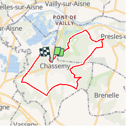
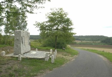
Trail Walking of 14.3 km to be discovered at Hauts-de-France, Aisne, Chassemy. This trail is proposed by tracegps.

Description

Entre les deux vallées de l’Aisne et de la Vesle, on peut voir les « boves », ces grottes creusées près de Notre-Dame-des-Boves, et profiter d’une vue panoramique sur les villages alentours. Retrouvez toutes les informations nécessaires ICI.

Elevation profile

Photos

Positioning

Country:
France
Region :
Hauts-de-France
Department/Province :
Aisne
Municipality :
Chassemy
Location:
Unknown
Start:(UTM)
536730 ; 5469977 (31U) N.

Trails nearby

Trail Walking Chivres-Val - Fort de condé - chivres - Photo
Walking
fitz2014

Walking

Very difficult
(1)
Chivres-Val, Hauts-de-France, Aisne, France
18 km | 22 km-effort
4h 48min
Yes
Trail Walking Chivres-Val - 11 la fontaine St ouen - Photo
Walking
fitz2014

Walking

Medium
Chivres-Val, Hauts-de-France, Aisne, France
14.1 km | 17.5 km-effort
3h 53min
Yes
Trail Walking Chivres-Val - Autour du fort de Condé - Photo
Walking

Walking

Very easy
Chivres-Val, Hauts-de-France, Aisne, France
939 m | 999 m-effort
Unknown
Yes
Trail Walking Chivres-Val - Chivres Val - La Fontaine de St Ouen - Photo
Walking
tracegps

Walking

Medium
Chivres-Val, Hauts-de-France, Aisne, France
12 km | 15.1 km-effort
4h 0min
No
Trail Walking Braine - La Folie - Photo
Walking
tracegps

Walking

Very difficult
(1)
Braine, Hauts-de-France, Aisne, France
8.4 km | 10.6 km-effort
3h 0min
Yes
Trail Walking Couvrelles - Les échauguettes - Photo
Walking
tracegps

Walking

Very difficult
Couvrelles, Hauts-de-France, Aisne, France
9.4 km | 12 km-effort
3h 0min
Yes
Trail Walking Vailly-sur-Aisne - Les roches de l'Abondin - Photo
Walking
tracegps

Walking

Very difficult
(1)
Vailly-sur-Aisne, Hauts-de-France, Aisne, France
9.8 km | 13.2 km-effort
3h 0min
Yes
Trail Walking Chivres-Val - la fontaine de Saint - Ouen . - Photo
Walking
José800

Walking

Difficult
Chivres-Val, Hauts-de-France, Aisne, France
12.6 km | 15.7 km-effort
3h 33min
Yes
Trail Walking Vailly-sur-Aisne - 2021-08-06 balade vailly - Photo
Walking
rolandmonjean

Walking

Very easy
Vailly-sur-Aisne, Hauts-de-France, Aisne, France
5.2 km | 5.8 km-effort
2h 29min
Yes


Close
My subscriptions