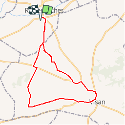
![](/images/other/stat-length.png)
![Trail Mountain bike Richerenches - De Richerenches à Visan - Photo](https://media.geolcdn.com/t/1900/400/ext.pjpeg?maxdim=2&url=https%3A%2F%2Fservices.sitytrail.com%2FGeolivesWS%2FDownloadMedia.ashx%3FTrailID%3D110335%26Media%3D5779_1.jpg)
De Richerenches à Visan
tracegps
User
![Length](/images/other/stat-length.png)
![Max alt](https://static1.geolcdn.com/siteimages/upload/files/1508320355ic_sort_altitude_max_24dp.png)
![Uphill gradient](https://static1.geolcdn.com/siteimages/upload/files/1508320355ic_sort_den_pos_24dp.png)
![Km-Effort](/images/other/stat-length.png)
![Min alt](https://static1.geolcdn.com/siteimages/upload/files/1508320355ic_sort_altitude_min_24dp.png)
![Downhill gradient](https://static1.geolcdn.com/siteimages/upload/files/1508320355ic_sort_den_neg_24dp.png)
![Boucle](https://static1.geolcdn.com/siteimages/upload/files/16400158638029165_repeat_loop_refresh_sync_direction_icon.png)
![Mountain bike](https://static1.geolcdn.com/sitytour/trail-icons/202.png)
1h30
Difficulty : Medium
![Scan this QR Code to open this trail in the SityTrail application](https://capi.geolives.com/qq0zvz2zws4bq2lad0pu/sitytour/trails/110335/qr.png?size=200)
FREE GPS app for hiking
About
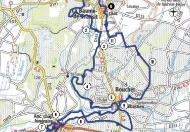
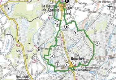
Trail Mountain bike of 16.6 km to be discovered at Provence-Alpes-Côte d'Azur, Vaucluse, Richerenches. This trail is proposed by tracegps.
Description
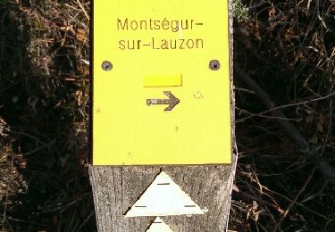
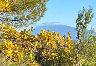
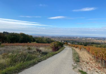
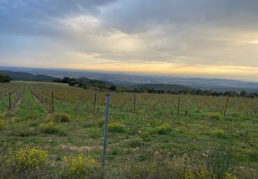
L’Enclave des Papes propose aux amoureux de la marche de nombreux circuits de randonnées, au départ de chacune des quatre communes. Reprenant le balisage du Conseil Général de Vaucluse, ces randonnées vous emmeneront tantôt au mileu des vignes et des champs de lavande, tantôt sous les bois de pins ou à proximité des champs de chênes truffiers, avec pour décor le Mont Ventoux ou la Lance. Vous partez vous promener, attention aux recommandations d’usage ! * Les espaces cultivés sont privés, merci de respecter le travail de chacun. * Avant de partir, pensez à emporter de l’eau en quantité suffisante. Les points d’eau sont peu nombreux sur les circuits. * Les chemins empruntés sont parfois caillouteux, pensez à vous chausser convenablement !
Positioning
Comments
Trails nearby
![Trail Walking Montségur-sur-Lauzon - Bassin des druides. Montségur-lauzon - Photo](https://media.geolcdn.com/t/375/260/ext.jpg?maxdim=2&url=https%3A%2F%2Fservices.sitytrail.com%2FGeolivesWS%2FDownloadMedia.ashx%3FTrailID%3D892897%26Media%3Dfix__20180124152347.jpg)
![Walking Walking](https://static1.geolcdn.com/sitytour/trail-icons/101.png)
Walking
![](/images/other/stat-length.png)
![](https://static1.geolcdn.com/siteimages/upload/files/16400158638029165_repeat_loop_refresh_sync_direction_icon.png)
![Walking Walking](https://static1.geolcdn.com/sitytour/trail-icons/101.png)
Walking
![](/images/other/stat-length.png)
![](https://static1.geolcdn.com/siteimages/upload/files/16400158638029165_repeat_loop_refresh_sync_direction_icon.png)
![Trail Walking Chamaret - Borries de chamaret - Photo](https://media.geolcdn.com/t/375/260/b3d37c72-f479-4372-af81-515832aa3dd7.jpg&format=jpg&maxdim=2)
![Walking Walking](https://static1.geolcdn.com/sitytour/trail-icons/101.png)
Walking
![](/images/other/stat-length.png)
![](https://static1.geolcdn.com/siteimages/upload/files/16400158638029165_repeat_loop_refresh_sync_direction_icon.png)
![Trail Walking Visan - Visan petite balade - Photo](https://media.geolcdn.com/t/375/260/4d6906d4-89ce-4993-9d2f-363c7293a27e.jpg&format=jpg&maxdim=2)
![Walking Walking](https://static1.geolcdn.com/sitytour/trail-icons/101.png)
Walking
![](/images/other/stat-length.png)
![](https://static1.geolcdn.com/siteimages/upload/files/16400158638029165_repeat_loop_refresh_sync_direction_icon.png)
![Trail Walking Montségur-sur-Lauzon - la baume - Photo](https://media.geolcdn.com/t/375/260/eb762b23-82e9-4220-9c15-31359b3d81f6.jpg&format=jpg&maxdim=2)
![Walking Walking](https://static1.geolcdn.com/sitytour/trail-icons/101.png)
Walking
![](/images/other/stat-length.png)
![](https://static1.geolcdn.com/siteimages/upload/files/16400158638029165_repeat_loop_refresh_sync_direction_icon.png)
![Trail Mountain bike La Baume-de-Transit - Gravel - La Baume / Gigondas - Photo](https://media.geolcdn.com/t/375/260/e1aa9ea4-b99b-4e66-951d-5d72be6ddffb.jpg&format=jpg&maxdim=2)
![Mountain bike Mountain bike](https://static1.geolcdn.com/sitytour/trail-icons/202.png)
Mountain bike
![](/images/other/stat-length.png)
![](https://static1.geolcdn.com/siteimages/upload/files/16400158638029165_repeat_loop_refresh_sync_direction_icon.png)
![Trail Hybrid bike Montségur-sur-Lauzon - Gravel - Baume SUZE par étang St Pierre BOLLENE Les Fangeons La Garde - Photo](https://media.geolcdn.com/t/375/260/46831bbd-c9eb-4b53-85ed-0dfa136f6d7e.jpg&format=jpg&maxdim=2)
![Hybrid bike Hybrid bike](https://static1.geolcdn.com/sitytour/trail-icons/203.png)
Hybrid bike
![](/images/other/stat-length.png)
![](https://static1.geolcdn.com/siteimages/upload/files/16400158638029165_repeat_loop_refresh_sync_direction_icon.png)
![Trail Mountain bike La Baume-de-Transit - Circuit Bleu n°15 Les Esparants - Photo](https://media.geolcdn.com/t/375/260/6bac2c63-74f1-4408-8fa4-28c147d7e3a1.png&format=jpg&maxdim=2)
![Mountain bike Mountain bike](https://static1.geolcdn.com/sitytour/trail-icons/202.png)
Mountain bike
![](/images/other/stat-length.png)
![](https://static1.geolcdn.com/siteimages/upload/files/16400158638029165_repeat_loop_refresh_sync_direction_icon.png)
![Trail Mountain bike La Baume-de-Transit - Circuit Vert n°3 les Balmes - Photo](https://media.geolcdn.com/t/375/260/987d802c-aebd-4bf1-a3af-671d0a565a46.png&format=jpg&maxdim=2)
![Mountain bike Mountain bike](https://static1.geolcdn.com/sitytour/trail-icons/202.png)
Mountain bike
![](/images/other/stat-length.png)
![](https://static1.geolcdn.com/siteimages/upload/files/16400158638029165_repeat_loop_refresh_sync_direction_icon.png)