Trail Equestrian Saint-Bonnet-en-Champsaur - Devoluy J5 - St-Bonnet-en-Champsaur > Superdévoluy - Photo

Devoluy J5 - St-Bonnet-en-Champsaur > Superdévoluy

© OpenStreetMap contributors
Length
Length
23 km
Max alt
Max alt
1676 m
Uphill gradient
Uphill gradient
1120 m
Km-Effort
Km-Effort  
37 km
Min alt
Min alt
960 m
Downhill gradient
Downhill gradient
682 m
Boucle
Boucle
No
Creation date :
2019-05-06 11:01:48.703
Updated on :
2021-04-30 14:43:08.377

(0 Reviews)

Equestrian
Equestrian
4h49
Difficulty : Unknown

Scan this QR Code to open this trail in the SityTrail application

FREE GPS app for hiking

Logo SityTrail SityTrail

IGN / Geographical institutes

Download SityTrail from the App Store Download SityTrail from Google Play

Logo SityTrail SityTrail World

The world is yours!

Download SityTrail from the App Store Download SityTrail from Google Play Download SityTrail on Huawei AppGallery

About

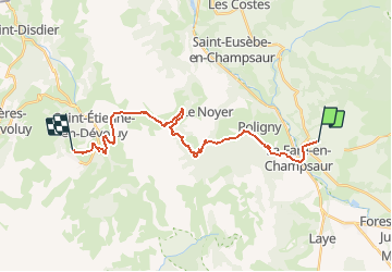
Trail Equestrian of 23 km to be discovered at Provence-Alpes-Côte d'Azur, Hautes-Alpes, Saint-Bonnet-en-Champsaur. This trail is proposed by AnaisLambert.

Description

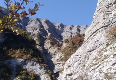
Traversé de 2 torrents sur le GR93. Il y a un passage mais qui peut évoluer en fonction des éboulies.

Elevation profile

Points of interest

Point of interest Le Noyer - La griotte - Photo
AnaisLambert
LE NOYER 
Point of interest Le Dévoluy - Gîte Les Miloux - Photo
AnaisLambert
LE DÉVOLUY 
Point of interest Le Dévoluy - Evelyne CHAILLOL - Photo
AnaisLambert
LE DÉVOLUY 

Positioning

Country:
France
Region :
Provence-Alpes-Côte d'Azur
Department/Province :
Hautes-Alpes
Municipality :
Saint-Bonnet-en-Champsaur
Location:
Saint-Bonnet-en-Champsaur
Start:(UTM)
268863 ; 4952020 (32T) N.

Trails nearby

Trail Walking Saint-Bonnet-en-Champsaur - Les infournas  -  Lac des Barbeyroux 22/09/23 - Photo
Walking
GUIDE
R@ph

Walking

Difficult
Saint-Bonnet-en-Champsaur, Provence-Alpes-Côte d'Azur, Hautes-Alpes, France
10.1 km | 16 km-effort
3h 38min
Yes
Trail Walking Poligny - La Cascade Sainte-Catherine et la Cabane des Pierres - Photo
Walking
frizou83

Walking

Very difficult
(1)
Poligny, Provence-Alpes-Côte d'Azur, Hautes-Alpes, France
9 km | 19 km-effort
4h 19min
Yes
Trail Walking Poligny - Sommet du Chamois - Photo
Walking
GUIDE
Marco05

Walking

Difficult
Poligny, Provence-Alpes-Côte d'Azur, Hautes-Alpes, France
8 km | 18.6 km-effort
4h 13min
Yes
Trail Walking La Fare-en-Champsaur - Le Girolet  - Photo
Walking
GUIDE
nadd73

Walking

Medium
La Fare-en-Champsaur, Provence-Alpes-Côte d'Azur, Hautes-Alpes, France
11.6 km | 24 km-effort
4h 45min
Yes
Trail Walking Laye - Sentier de la Cuque prolongé - Photo
Walking
frederique.marti@laposte.net

Walking

Very easy
(1)
Laye, Provence-Alpes-Côte d'Azur, Hautes-Alpes, France
11.8 km | 19.7 km-effort
2h 24min
Yes
Trail Walking Poligny - La Cascade Sainte-Catherine et la Cabane des Pierres avec AR au col de Chétive - Photo
Walking
frizou83

Walking

Very difficult
(1)
Poligny, Provence-Alpes-Côte d'Azur, Hautes-Alpes, France
9.5 km | 19.4 km-effort
4h 25min
Yes
Trail Walking Poligny - La Cascade Sainte-Catherine et la Cabane des Pierres et retour Laye par Chaudun - Photo
Walking
frizou83

Walking

Very difficult
(1)
Poligny, Provence-Alpes-Côte d'Azur, Hautes-Alpes, France
19.8 km | 40 km-effort
9h 2min
No
Trail Walking Saint-Laurent-du-Cros - St Laurent du Cros 27/01/24 - Photo
Walking
GUIDE
R@ph

Walking

Easy
Saint-Laurent-du-Cros, Provence-Alpes-Côte d'Azur, Hautes-Alpes, France
6.9 km | 9.2 km-effort
2h 4min
Yes
Trail Walking La Fare-en-Champsaur - Le Bois Vert Station de Laye  - Photo
Walking
sereton

Walking

Medium
(1)
La Fare-en-Champsaur, Provence-Alpes-Côte d'Azur, Hautes-Alpes, France
9.1 km | 13.1 km-effort
2h 44min
Yes


Close
My subscriptions