Trail Walking Saint-Mars-de-Locquenay - Saint Mars de Locquenay - 10km - Photo

Saint Mars de Locquenay - 10km

 tracegps
tracegps

User

© OpenStreetMap contributors
Length
Length
10.8 km
Max alt
Max alt
168 m
Uphill gradient
Uphill gradient
149 m
Km-Effort
Km-Effort  
12.8 km
Min alt
Min alt
109 m
Downhill gradient
Downhill gradient
149 m
Boucle
Boucle
Yes
Creation date :
2014-12-10 00:00:00.0
Updated on :
2014-12-10 00:00:00.0

(1 Reviews)

Walking
Walking
2h30
Difficulty : Medium

Scan this QR Code to open this trail in the SityTrail application

FREE GPS app for hiking

Logo SityTrail SityTrail

IGN / Geographical institutes

Download SityTrail from the App Store Download SityTrail from Google Play

Logo SityTrail SityTrail World

The world is yours!

Download SityTrail from the App Store Download SityTrail from Google Play Download SityTrail on Huawei AppGallery

About

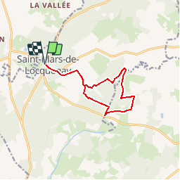
Trail Walking of 10.8 km to be discovered at Pays de la Loire, Sarthe, Saint-Mars-de-Locquenay. This trail is proposed by tracegps.

Description

A la découverte des trésors cachés du Perche Sarthois Saint Mars de Locquenay - 10km Le mot « Locquenay » exprimerait une surface important en eau (étang ou lac) ou cave aux oiseaux. Quoi qu’il en soit, cette zone reste toujours fortement humide.

Elevation profile

Photos

Positioning

Country:
France
Region :
Pays de la Loire
Department/Province :
Sarthe
Municipality :
Saint-Mars-de-Locquenay
Location:
Unknown
Start:(Dec)
Start:(UTM)
312093 ; 5311374 (31T) N.

Comments

Please log in to post a review or rate the element


Trails nearby

Trail Mountain bike Saint-Mars-de-Locquenay - Rando de St Mars de Locquenay - Photo
Mountain bike
tracegps

Mountain bike

Medium
Saint-Mars-de-Locquenay, Pays de la Loire, Sarthe, France
38 km | 45 km-effort
3h 0min
Yes
Trail Walking Saint-Mars-de-Locquenay - Saint Mars de Locquenay - 21km - Photo
Walking
tracegps

Walking

Medium
Saint-Mars-de-Locquenay, Pays de la Loire, Sarthe, France
21 km | 24 km-effort
5h 0min
Yes
Trail Mountain bike Challes - La Randonnée Nature 2010 - Challes - Photo
Mountain bike
tracegps

Mountain bike

Difficult
Challes, Pays de la Loire, Sarthe, France
55 km | 64 km-effort
3h 10min
Yes
Trail On foot Volnay - Circuit vert - Photo
On foot
PRO

On foot

Easy
Volnay, Pays de la Loire, Sarthe, France
12.4 km | 14.3 km-effort
3h 15min
Yes
Trail On foot Volnay - Circuit jaune - Photo
On foot
PRO

On foot

Easy
Volnay, Pays de la Loire, Sarthe, France
8.7 km | 9.9 km-effort
2h 15min
Yes
Trail On foot Volnay - Circuit bleu - Photo
On foot
PRO

On foot

Medium
Volnay, Pays de la Loire, Sarthe, France
21 km | 25 km-effort
5h 36min
Yes
Trail Walking Volnay - le carrefour ricochet - Photo
Walking
SERUS

Walking

Medium
Volnay, Pays de la Loire, Sarthe, France
24 km | 27 km-effort
5h 25min
No
Trail Walking Volnay - A004-La Laire-Les Vernelles - Photo
Walking
SERUS

Walking

Easy
Volnay, Pays de la Loire, Sarthe, France
11.2 km | 12.6 km-effort
2h 46min
No
Trail Mountain bike Volnay - grande boucle VTT - Photo
Mountain bike
jef.volnay

Mountain bike

Very easy
(1)
Volnay, Pays de la Loire, Sarthe, France
26 km | 30 km-effort
1h 56min
Yes


Close
My subscriptions