![](/images/other/stat-length.png)
![Trail Walking Saint-Tricat - La boucle des marais - St Tricat - Photo](https://media.geolcdn.com/t/1900/400/ext.pjpeg?maxdim=2&url=https%3A%2F%2Fservices.sitytrail.com%2FGeolivesWS%2FDownloadMedia.ashx%3FTrailID%3D110279%26Media%3D5673_6.jpg)
La boucle des marais - St Tricat
tracegps
User
![Length](/images/other/stat-length.png)
Length
10.5 km
![Max alt](https://static1.geolcdn.com/siteimages/upload/files/1508320355ic_sort_altitude_max_24dp.png)
Max alt
26 m
![Uphill gradient](https://static1.geolcdn.com/siteimages/upload/files/1508320355ic_sort_den_pos_24dp.png)
Uphill gradient
54 m
![Km-Effort](/images/other/stat-length.png)
Km-Effort
11.3 km
![Min alt](https://static1.geolcdn.com/siteimages/upload/files/1508320355ic_sort_altitude_min_24dp.png)
Min alt
-3 m
![Downhill gradient](https://static1.geolcdn.com/siteimages/upload/files/1508320355ic_sort_den_neg_24dp.png)
Downhill gradient
51 m
![Boucle](https://static1.geolcdn.com/siteimages/upload/files/16400158638029165_repeat_loop_refresh_sync_direction_icon.png)
Boucle
Yes
Creation date :
2014-12-10 00:00:00.0
Updated on :
2014-12-10 00:00:00.0
![Walking](https://static1.geolcdn.com/sitytour/trail-icons/101.png)
2h40
Difficulty : Medium
![Scan this QR Code to open this trail in the SityTrail application](https://capi.geolives.com/qq0zvz2zws4bq2lad0pu/sitytour/trails/110279/qr.png?size=200)
FREE GPS app for hiking
About
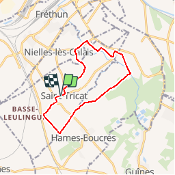
Trail Walking of 10.5 km to be discovered at Hauts-de-France, Pas-de-Calais, Saint-Tricat. This trail is proposed by tracegps.
Description
Circuit proposé par la Communauté de communes du Sud-Ouest du Calaisis Départ de la mairie de St Tricat ou de la mairie de Nielles-Lès-Calais. Ce circuit a été numérisé par les randonneurs du CODEPEM. Merci à Jean-Marie.
Positioning
Country:
France
Region :
Hauts-de-France
Department/Province :
Pas-de-Calais
Municipality :
Saint-Tricat
Location:
Unknown
Start:(Dec)
Start:(UTM)
417758 ; 5638621 (31U) N.
Comments
Trails nearby
![Trail Walking Pihen-lès-Guînes - Sentier des crêtes - Pihen-les-Guînes - Photo](https://media.geolcdn.com/t/375/260/ext.jpg?maxdim=2&url=https%3A%2F%2Fservices.sitytrail.com%2FGeolivesWS%2FDownloadMedia.ashx%3FTrailID%3D111903%26Media%3D8906_6.jpg)
![Walking Walking](https://static1.geolcdn.com/sitytour/trail-icons/101.png)
Sentier des crêtes - Pihen-les-Guînes
Walking
Medium
(1)
Pihen-lès-Guînes,
Hauts-de-France,
Pas-de-Calais,
France
![](/images/other/stat-length.png)
8.2 km | 9.4 km-effort
2h 4min
![](https://static1.geolcdn.com/siteimages/upload/files/16400158638029165_repeat_loop_refresh_sync_direction_icon.png)
Yes
![Trail Walking Bonningues-lès-Calais - Chemin de la Folie - Bonningues-les-Calais - Photo](https://media.geolcdn.com/t/375/260/ext.jpg?maxdim=2&url=https%3A%2F%2Fservices.sitytrail.com%2FGeolivesWS%2FDownloadMedia.ashx%3FTrailID%3D110304%26Media%3D5728_3.jpg)
![Walking Walking](https://static1.geolcdn.com/sitytour/trail-icons/101.png)
Chemin de la Folie - Bonningues-les-Calais
Walking
Medium
Bonningues-lès-Calais,
Hauts-de-France,
Pas-de-Calais,
France
![](/images/other/stat-length.png)
9.8 km | 11.5 km-effort
2h 30min
![](https://static1.geolcdn.com/siteimages/upload/files/16400158638029165_repeat_loop_refresh_sync_direction_icon.png)
Yes
![Trail Walking Peuplingues - Sentier des fonds - Peuplingues - Photo](https://media.geolcdn.com/t/375/260/ext.jpg?maxdim=2&url=https%3A%2F%2Fservices.sitytrail.com%2FGeolivesWS%2FDownloadMedia.ashx%3FTrailID%3D110293%26Media%3D5691_6.jpg)
![Walking Walking](https://static1.geolcdn.com/sitytour/trail-icons/101.png)
Sentier des fonds - Peuplingues
Walking
Medium
(1)
Peuplingues,
Hauts-de-France,
Pas-de-Calais,
France
![](/images/other/stat-length.png)
11.2 km | 13.3 km-effort
2h 49min
![](https://static1.geolcdn.com/siteimages/upload/files/16400158638029165_repeat_loop_refresh_sync_direction_icon.png)
Yes
![Trail On foot Landrethun-le-Nord - Sentiers des Poissonniers - Photo](https://media.geolcdn.com/t/375/260/53724d4e-7c77-42a5-9380-d311f217794e.jpeg&format=jpg&maxdim=2)
![On foot On foot](https://static1.geolcdn.com/sitytour/trail-icons/100.png)
Sentiers des Poissonniers
On foot
Easy
Landrethun-le-Nord,
Hauts-de-France,
Pas-de-Calais,
France
![](/images/other/stat-length.png)
9.4 km | 11.2 km-effort
2h 33min
![](https://static1.geolcdn.com/siteimages/upload/files/16400158638029165_repeat_loop_refresh_sync_direction_icon.png)
No
![Trail Walking Guînes - guines APM - Photo](https://media.geolcdn.com/t/375/260/ext.jpg?maxdim=2&url=https%3A%2F%2Fstatic1.geolcdn.com%2Fsiteimages%2Fupload%2Ffiles%2F1553511878bg_sport_marche.png)
![Walking Walking](https://static1.geolcdn.com/sitytour/trail-icons/101.png)
guines APM
Walking
Easy
Guînes,
Hauts-de-France,
Pas-de-Calais,
France
![](/images/other/stat-length.png)
5.5 km | 5.8 km-effort
1h 21min
![](https://static1.geolcdn.com/siteimages/upload/files/16400158638029165_repeat_loop_refresh_sync_direction_icon.png)
No
![Trail Nordic walking Peuplingues - MN de Peuplingues à Escalles en matinée - Photo](https://media.geolcdn.com/t/375/260/ext.jpg?maxdim=2&url=https%3A%2F%2Fstatic1.geolcdn.com%2Fsiteimages%2Fupload%2Ffiles%2F1545311037marcheuse_200dpi.jpg)
![Nordic walking Nordic walking](https://static1.geolcdn.com/sitytour/trail-icons/102.png)
MN de Peuplingues à Escalles en matinée
Nordic walking
Easy
Peuplingues,
Hauts-de-France,
Pas-de-Calais,
France
![](/images/other/stat-length.png)
14.8 km | 16.5 km-effort
3h 0min
![](https://static1.geolcdn.com/siteimages/upload/files/16400158638029165_repeat_loop_refresh_sync_direction_icon.png)
No
![Trail Mountain bike Coquelles - rando-de-coquelles - Photo](https://media.geolcdn.com/t/375/260/ext.jpg?maxdim=2&url=https%3A%2F%2Fstatic1.geolcdn.com%2Fsiteimages%2Fupload%2Ffiles%2F1524743154velo.jpg)
![Mountain bike Mountain bike](https://static1.geolcdn.com/sitytour/trail-icons/202.png)
rando-de-coquelles
Mountain bike
Very difficult
Coquelles,
Hauts-de-France,
Pas-de-Calais,
France
![](/images/other/stat-length.png)
87 km | 106 km-effort
7h 19min
![](https://static1.geolcdn.com/siteimages/upload/files/16400158638029165_repeat_loop_refresh_sync_direction_icon.png)
Yes
![Trail Mountain bike Coquelles - 90-kms-raid-du-roc-d-opale - Photo](https://media.geolcdn.com/t/375/260/ext.jpg?maxdim=2&url=https%3A%2F%2Fstatic1.geolcdn.com%2Fsiteimages%2Fupload%2Ffiles%2F1524743154velo.jpg)
![Mountain bike Mountain bike](https://static1.geolcdn.com/sitytour/trail-icons/202.png)
90-kms-raid-du-roc-d-opale
Mountain bike
Very difficult
Coquelles,
Hauts-de-France,
Pas-de-Calais,
France
![](/images/other/stat-length.png)
90 km | 110 km-effort
7h 38min
![](https://static1.geolcdn.com/siteimages/upload/files/16400158638029165_repeat_loop_refresh_sync_direction_icon.png)
Yes
![Trail Walking Coquelles - ballade Coquelles cap blanc nez - Photo](https://media.geolcdn.com/t/375/260/ext.jpg?maxdim=2&url=https%3A%2F%2Fstatic1.geolcdn.com%2Fsiteimages%2Fupload%2Ffiles%2F1553511878bg_sport_marche.png)
![Walking Walking](https://static1.geolcdn.com/sitytour/trail-icons/101.png)
ballade Coquelles cap blanc nez
Walking
Medium
Coquelles,
Hauts-de-France,
Pas-de-Calais,
France
![](/images/other/stat-length.png)
8.2 km | 8.9 km-effort
3h 28min
![](https://static1.geolcdn.com/siteimages/upload/files/16400158638029165_repeat_loop_refresh_sync_direction_icon.png)
No