![](/images/other/stat-length.png)
![Trail Walking Thorigné-sur-Dué - Thorigné sur Dué - A l'ombre des haies, variante les Trois Chênes - Photo](https://media.geolcdn.com/t/1900/400/ext.pjpeg?maxdim=2&url=https%3A%2F%2Fservices.sitytrail.com%2FGeolivesWS%2FDownloadMedia.ashx%3FTrailID%3D110246%26Media%3D5546_1.jpg)
Thorigné sur Dué - A l'ombre des haies, variante les Trois Chênes
tracegps
User
![Length](/images/other/stat-length.png)
Length
8.3 km
![Max alt](https://static1.geolcdn.com/siteimages/upload/files/1508320355ic_sort_altitude_max_24dp.png)
Max alt
145 m
![Uphill gradient](https://static1.geolcdn.com/siteimages/upload/files/1508320355ic_sort_den_pos_24dp.png)
Uphill gradient
110 m
![Km-Effort](/images/other/stat-length.png)
Km-Effort
9.8 km
![Min alt](https://static1.geolcdn.com/siteimages/upload/files/1508320355ic_sort_altitude_min_24dp.png)
Min alt
82 m
![Downhill gradient](https://static1.geolcdn.com/siteimages/upload/files/1508320355ic_sort_den_neg_24dp.png)
Downhill gradient
116 m
![Boucle](https://static1.geolcdn.com/siteimages/upload/files/16400158638029165_repeat_loop_refresh_sync_direction_icon.png)
Boucle
Yes
Creation date :
2014-12-10 00:00:00.0
Updated on :
2014-12-10 00:00:00.0
![Walking](https://static1.geolcdn.com/sitytour/trail-icons/101.png)
2h00
Difficulty : Medium
![Scan this QR Code to open this trail in the SityTrail application](https://capi.geolives.com/qq0zvz2zws4bq2lad0pu/sitytour/trails/110246/qr.png?size=200)
FREE GPS app for hiking
About
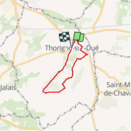
Trail Walking of 8.3 km to be discovered at Pays de la Loire, Sarthe, Thorigné-sur-Dué. This trail is proposed by tracegps.
Description
A la découverte des trésors cachés du Perche Sarthois Thorigné sur Dué - A l'ombre des haies, variante les Trois Chênes A voir en chemin grande diversité d’espèces d’arbres, Hameau des Haies.
Positioning
Country:
France
Region :
Pays de la Loire
Department/Province :
Sarthe
Municipality :
Thorigné-sur-Dué
Location:
Unknown
Start:(Dec)
Start:(UTM)
316168 ; 5323365 (31U) N.
Comments
Trails nearby
![Trail Walking Dollon - Dollon - Semur en Vallon - Lavaré - Nostalgie des Années 30... - Photo](https://media.geolcdn.com/t/375/260/ext.jpg?maxdim=2&url=https%3A%2F%2Fservices.sitytrail.com%2FGeolivesWS%2FDownloadMedia.ashx%3FTrailID%3D110418%26Media%3D5892_1.jpg)
![Walking Walking](https://static1.geolcdn.com/sitytour/trail-icons/101.png)
Dollon - Semur en Vallon - Lavaré - Nostalgie des Années 30...
Walking
Difficult
Dollon,
Pays de la Loire,
Sarthe,
France
![](/images/other/stat-length.png)
22 km | 26 km-effort
5h 0min
![](https://static1.geolcdn.com/siteimages/upload/files/16400158638029165_repeat_loop_refresh_sync_direction_icon.png)
Yes
![Trail Walking Thorigné-sur-Dué - Thorigné sur Dué - A l'ombre des haies 14km - Photo](https://media.geolcdn.com/t/375/260/ext.jpg?maxdim=2&url=https%3A%2F%2Fservices.sitytrail.com%2FGeolivesWS%2FDownloadMedia.ashx%3FTrailID%3D110247%26Media%3D5547_1.jpg)
![Walking Walking](https://static1.geolcdn.com/sitytour/trail-icons/101.png)
Thorigné sur Dué - A l'ombre des haies 14km
Walking
Medium
Thorigné-sur-Dué,
Pays de la Loire,
Sarthe,
France
![](/images/other/stat-length.png)
13.5 km | 15.7 km-effort
3h 30min
![](https://static1.geolcdn.com/siteimages/upload/files/16400158638029165_repeat_loop_refresh_sync_direction_icon.png)
Yes
![Trail Walking Thorigné-sur-Dué - Thorigné sur Dué - A l'ombre des haies, variante La Pagerie - Photo](https://media.geolcdn.com/t/375/260/ext.jpg?maxdim=2&url=https%3A%2F%2Fservices.sitytrail.com%2FGeolivesWS%2FDownloadMedia.ashx%3FTrailID%3D110245%26Media%3D5545_1.jpg)
![Walking Walking](https://static1.geolcdn.com/sitytour/trail-icons/101.png)
Thorigné sur Dué - A l'ombre des haies, variante La Pagerie
Walking
Easy
Thorigné-sur-Dué,
Pays de la Loire,
Sarthe,
France
![](/images/other/stat-length.png)
5 km | 5.8 km-effort
1h 15min
![](https://static1.geolcdn.com/siteimages/upload/files/16400158638029165_repeat_loop_refresh_sync_direction_icon.png)
Yes
![Trail Walking Saint-Michel-de-Chavaignes - st Michel de chavaigne - Photo](https://media.geolcdn.com/t/375/260/ext.jpg?maxdim=2&url=https%3A%2F%2Fstatic1.geolcdn.com%2Fsiteimages%2Fupload%2Ffiles%2F1553511878bg_sport_marche.png)
![Walking Walking](https://static1.geolcdn.com/sitytour/trail-icons/101.png)
st Michel de chavaigne
Walking
Medium
Saint-Michel-de-Chavaignes,
Pays de la Loire,
Sarthe,
France
![](/images/other/stat-length.png)
12.6 km | 15.1 km-effort
3h 26min
![](https://static1.geolcdn.com/siteimages/upload/files/16400158638029165_repeat_loop_refresh_sync_direction_icon.png)
Yes
![Trail Walking Thorigné-sur-Dué - Thorigné-sur-Dué - Photo](https://media.geolcdn.com/t/375/260/ext.jpg?maxdim=2&url=https%3A%2F%2Fstatic1.geolcdn.com%2Fsiteimages%2Fupload%2Ffiles%2F1553511878bg_sport_marche.png)
![Walking Walking](https://static1.geolcdn.com/sitytour/trail-icons/101.png)
Thorigné-sur-Dué
Walking
Very easy
Thorigné-sur-Dué,
Pays de la Loire,
Sarthe,
France
![](/images/other/stat-length.png)
13.5 km | 15.7 km-effort
3h 27min
![](https://static1.geolcdn.com/siteimages/upload/files/16400158638029165_repeat_loop_refresh_sync_direction_icon.png)
Yes
![Trail Running Le Breil-sur-Mérize - Thorigne autour de la route des haies - Photo](https://media.geolcdn.com/t/375/260/ext.jpg?maxdim=2&url=https%3A%2F%2Fstatic1.geolcdn.com%2Fsiteimages%2Fupload%2Ffiles%2F1524743154running.jpg)
![Running Running](https://static1.geolcdn.com/sitytour/trail-icons/103.png)
Thorigne autour de la route des haies
Running
Very easy
Le Breil-sur-Mérize,
Pays de la Loire,
Sarthe,
France
![](/images/other/stat-length.png)
21 km | 25 km-effort
3h 8min
![](https://static1.geolcdn.com/siteimages/upload/files/16400158638029165_repeat_loop_refresh_sync_direction_icon.png)
Yes
![Trail Walking Dollon - Dollon - Photo](https://media.geolcdn.com/t/375/260/ext.jpg?maxdim=2&url=https%3A%2F%2Fstatic1.geolcdn.com%2Fsiteimages%2Fupload%2Ffiles%2F1553511878bg_sport_marche.png)
![Walking Walking](https://static1.geolcdn.com/sitytour/trail-icons/101.png)
Dollon
Walking
Very easy
Dollon,
Pays de la Loire,
Sarthe,
France
![](/images/other/stat-length.png)
12.1 km | 15.1 km-effort
Unknown
![](https://static1.geolcdn.com/siteimages/upload/files/16400158638029165_repeat_loop_refresh_sync_direction_icon.png)
Yes
![Trail sport Connerré - CIRCUIT VÉLO N°9 LE BERCEAU DES RILLETTES DU PERCHE SARTHOIS 44km - Photo](https://media.geolcdn.com/t/375/260/ext.jpg?maxdim=2&url=https%3A%2F%2Fsecurestorage.geolives.com%2Fsitytour%2Ftrail-bg%2Fdefault.jpg)
CIRCUIT VÉLO N°9 LE BERCEAU DES RILLETTES DU PERCHE SARTHOIS 44km
sport
Very easy
Connerré,
Pays de la Loire,
Sarthe,
France
![](/images/other/stat-length.png)
43 km | 49 km-effort
Unknown
![](https://static1.geolcdn.com/siteimages/upload/files/16400158638029165_repeat_loop_refresh_sync_direction_icon.png)
Yes
![Trail Cycle Saint-Michel-de-Chavaignes - La Fenderie 40 km - Photo](https://media.geolcdn.com/t/375/260/ext.jpg?maxdim=2&url=https%3A%2F%2Fstatic1.geolcdn.com%2Fsiteimages%2Fupload%2Ffiles%2F1524743154velo.jpg)
![Cycle Cycle](https://static1.geolcdn.com/sitytour/trail-icons/200.png)
La Fenderie 40 km
Cycle
Very easy
Saint-Michel-de-Chavaignes,
Pays de la Loire,
Sarthe,
France
![](/images/other/stat-length.png)
39 km | 46 km-effort
Unknown
![](https://static1.geolcdn.com/siteimages/upload/files/16400158638029165_repeat_loop_refresh_sync_direction_icon.png)
Yes