![](/images/other/stat-length.png)
![Trail Walking Mesnil-en-Ouche - Circuit de la campagne des bois - St-Pierre du Mesnil - Photo](https://media.geolcdn.com/t/1900/400/ext.pjpeg?maxdim=2&url=https%3A%2F%2Fservices.sitytrail.com%2FGeolivesWS%2FDownloadMedia.ashx%3FTrailID%3D110188%26Media%3D5410_6.jpg)
Circuit de la campagne des bois - St-Pierre du Mesnil
tracegps
User
![Length](/images/other/stat-length.png)
Length
8.9 km
![Max alt](https://static1.geolcdn.com/siteimages/upload/files/1508320355ic_sort_altitude_max_24dp.png)
Max alt
213 m
![Uphill gradient](https://static1.geolcdn.com/siteimages/upload/files/1508320355ic_sort_den_pos_24dp.png)
Uphill gradient
45 m
![Km-Effort](/images/other/stat-length.png)
Km-Effort
9.5 km
![Min alt](https://static1.geolcdn.com/siteimages/upload/files/1508320355ic_sort_altitude_min_24dp.png)
Min alt
197 m
![Downhill gradient](https://static1.geolcdn.com/siteimages/upload/files/1508320355ic_sort_den_neg_24dp.png)
Downhill gradient
46 m
![Boucle](https://static1.geolcdn.com/siteimages/upload/files/16400158638029165_repeat_loop_refresh_sync_direction_icon.png)
Boucle
Yes
Creation date :
2014-12-10 00:00:00.0
Updated on :
2014-12-10 00:00:00.0
![Walking](https://static1.geolcdn.com/sitytour/trail-icons/101.png)
2h15
Difficulty : Medium
![Scan this QR Code to open this trail in the SityTrail application](https://capi.geolives.com/qq0zvz2zws4bq2lad0pu/sitytour/trails/110188/qr.png?size=200)
FREE GPS app for hiking
About
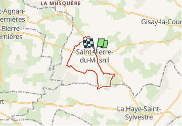
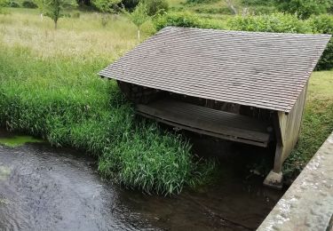
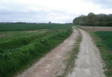
Trail Walking of 8.9 km to be discovered at Normandy, Eure, Mesnil-en-Ouche. This trail is proposed by tracegps.
Description
Circuit proposé par la Communauté de Communes du canton de Beaumesnil et l’Office de Tourisme de Beaumesnil. Départ de la mairie de St-Pierre du Mesnil à coté de l’église. Retrouvez ce circuit, parmi 17 autres, sur le dépliant proposé par l’office de Tourisme.
Positioning
Country:
France
Region :
Normandy
Department/Province :
Eure
Municipality :
Mesnil-en-Ouche
Location:
Unknown
Start:(Dec)
Start:(UTM)
322580 ; 5423106 (31U) N.
Comments
Trails nearby
![Trail Walking Mesnil-en-Ouche - Circuit des bois de St Ouen - Gisay-la-Coudre - Photo](https://media.geolcdn.com/t/375/260/ext.jpg?maxdim=2&url=https%3A%2F%2Fservices.sitytrail.com%2FGeolivesWS%2FDownloadMedia.ashx%3FTrailID%3D110208%26Media%3D5453_6.jpg)
![Walking Walking](https://static1.geolcdn.com/sitytour/trail-icons/101.png)
Circuit des bois de St Ouen - Gisay-la-Coudre
Walking
Difficult
Mesnil-en-Ouche,
Normandy,
Eure,
France
![](/images/other/stat-length.png)
16.3 km | 17.6 km-effort
4h 0min
![](https://static1.geolcdn.com/siteimages/upload/files/16400158638029165_repeat_loop_refresh_sync_direction_icon.png)
Yes
![Trail Mountain bike Mesnil-en-Ouche - Circuit de la campagne des bois - St-Pierre du Mesnil - Photo](https://media.geolcdn.com/t/375/260/ext.jpg?maxdim=2&url=https%3A%2F%2Fservices.sitytrail.com%2FGeolivesWS%2FDownloadMedia.ashx%3FTrailID%3D110189%26Media%3D5410_6.jpg)
![Mountain bike Mountain bike](https://static1.geolcdn.com/sitytour/trail-icons/202.png)
Circuit de la campagne des bois - St-Pierre du Mesnil
Mountain bike
Easy
Mesnil-en-Ouche,
Normandy,
Eure,
France
![](/images/other/stat-length.png)
8.9 km | 9.5 km-effort
1h 0min
![](https://static1.geolcdn.com/siteimages/upload/files/16400158638029165_repeat_loop_refresh_sync_direction_icon.png)
Yes
![Trail Walking La Trinité-de-Réville - la trinite de Reville - Photo](https://media.geolcdn.com/t/375/260/3d651fcd-4702-45e6-b71c-7213c89a3859.jpg&format=jpg&maxdim=2)
![Walking Walking](https://static1.geolcdn.com/sitytour/trail-icons/101.png)
la trinite de Reville
Walking
Medium
La Trinité-de-Réville,
Normandy,
Eure,
France
![](/images/other/stat-length.png)
9.8 km | 12 km-effort
2h 3min
![](https://static1.geolcdn.com/siteimages/upload/files/16400158638029165_repeat_loop_refresh_sync_direction_icon.png)
Yes
![Trail Walking Saint-Agnan-de-Cernières - Boucle des Cernières - Saint-Agnan de Cernières - Photo](https://media.geolcdn.com/t/375/260/ext.jpg?maxdim=2&url=https%3A%2F%2Fservices.sitytrail.com%2FGeolivesWS%2FDownloadMedia.ashx%3FTrailID%3D110442%26Media%3D5925_1.jpg)
![Walking Walking](https://static1.geolcdn.com/sitytour/trail-icons/101.png)
Boucle des Cernières - Saint-Agnan de Cernières
Walking
Easy
Saint-Agnan-de-Cernières,
Normandy,
Eure,
France
![](/images/other/stat-length.png)
14.3 km | 15.8 km-effort
1h 0min
![](https://static1.geolcdn.com/siteimages/upload/files/16400158638029165_repeat_loop_refresh_sync_direction_icon.png)
Yes
![Trail Mountain bike Mesnil-en-Ouche - Circuit des Masniéres - La Roussière - Photo](https://media.geolcdn.com/t/375/260/ext.jpg?maxdim=2&url=https%3A%2F%2Fservices.sitytrail.com%2FGeolivesWS%2FDownloadMedia.ashx%3FTrailID%3D110211%26Media%3D5466_2.jpg)
![Mountain bike Mountain bike](https://static1.geolcdn.com/sitytour/trail-icons/202.png)
Circuit des Masniéres - La Roussière
Mountain bike
Easy
Mesnil-en-Ouche,
Normandy,
Eure,
France
![](/images/other/stat-length.png)
9.2 km | 9.7 km-effort
1h 0min
![](https://static1.geolcdn.com/siteimages/upload/files/16400158638029165_repeat_loop_refresh_sync_direction_icon.png)
Yes
![Trail Walking Mesnil-en-Ouche - Circuit des Masniéres - La Roussière - Photo](https://media.geolcdn.com/t/375/260/ext.jpg?maxdim=2&url=https%3A%2F%2Fservices.sitytrail.com%2FGeolivesWS%2FDownloadMedia.ashx%3FTrailID%3D110210%26Media%3D5466_2.jpg)
![Walking Walking](https://static1.geolcdn.com/sitytour/trail-icons/101.png)
Circuit des Masniéres - La Roussière
Walking
Medium
Mesnil-en-Ouche,
Normandy,
Eure,
France
![](/images/other/stat-length.png)
9.2 km | 9.7 km-effort
2h 15min
![](https://static1.geolcdn.com/siteimages/upload/files/16400158638029165_repeat_loop_refresh_sync_direction_icon.png)
Yes
![Trail Walking Saint-Agnan-de-Cernières - Saint Agnan de Cernières 27 - Photo](https://media.geolcdn.com/t/375/260/ext.jpg?maxdim=2&url=https%3A%2F%2Fstatic1.geolcdn.com%2Fsiteimages%2Fupload%2Ffiles%2F1553511878bg_sport_marche.png)
![Walking Walking](https://static1.geolcdn.com/sitytour/trail-icons/101.png)
Saint Agnan de Cernières 27
Walking
Medium
Saint-Agnan-de-Cernières,
Normandy,
Eure,
France
![](/images/other/stat-length.png)
8.1 km | 10.2 km-effort
2h 18min
![](https://static1.geolcdn.com/siteimages/upload/files/16400158638029165_repeat_loop_refresh_sync_direction_icon.png)
Yes
![Trail Walking La Trinité-de-Réville - la trinité de réville - Photo](https://media.geolcdn.com/t/375/260/63860b0b-853b-43dc-9ff1-2ce9c42d9eb1.jpg&format=jpg&maxdim=2)
![Walking Walking](https://static1.geolcdn.com/sitytour/trail-icons/101.png)
la trinité de réville
Walking
Medium
La Trinité-de-Réville,
Normandy,
Eure,
France
![](/images/other/stat-length.png)
9.7 km | 11.7 km-effort
2h 50min
![](https://static1.geolcdn.com/siteimages/upload/files/16400158638029165_repeat_loop_refresh_sync_direction_icon.png)
Yes
![Trail Walking La Trinité-de-Réville - Trinité de Réveille - Photo](https://media.geolcdn.com/t/375/260/ext.jpg?maxdim=2&url=https%3A%2F%2Fstatic1.geolcdn.com%2Fsiteimages%2Fupload%2Ffiles%2F1553511878bg_sport_marche.png)
![Walking Walking](https://static1.geolcdn.com/sitytour/trail-icons/101.png)
Trinité de Réveille
Walking
Easy
La Trinité-de-Réville,
Normandy,
Eure,
France
![](/images/other/stat-length.png)
8.8 km | 10.9 km-effort
2h 28min
![](https://static1.geolcdn.com/siteimages/upload/files/16400158638029165_repeat_loop_refresh_sync_direction_icon.png)
Yes