Trail Walking Fontaine-Chaalis - Autour de l'Abbaye de Chaalis - Photo

Autour de l'Abbaye de Chaalis

 tracegps
tracegps

User

© OpenStreetMap contributors
Length
Length
23 km
Max alt
Max alt
133 m
Uphill gradient
Uphill gradient
275 m
Km-Effort
Km-Effort  
27 km
Min alt
Min alt
62 m
Downhill gradient
Downhill gradient
272 m
Boucle
Boucle
Yes
Creation date :
2014-12-10 00:00:00.0
Updated on :
2014-12-10 00:00:00.0

(0 Reviews)

Walking
Walking
4h30
Difficulty : Difficult

Scan this QR Code to open this trail in the SityTrail application

FREE GPS app for hiking

Logo SityTrail SityTrail

IGN / Geographical institutes

Download SityTrail from the App Store Download SityTrail from Google Play

Logo SityTrail SityTrail World

The world is yours!

Download SityTrail from the App Store Download SityTrail from Google Play Download SityTrail on Huawei AppGallery

About

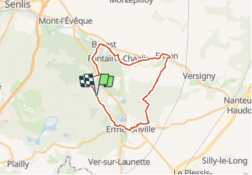
Trail Walking of 23 km to be discovered at Hauts-de-France, Oise, Fontaine-Chaalis. This trail is proposed by tracegps.

Description

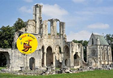
Circuit proposé par le Comité Départemental de Randonnée des Hauts de Seine. Chaalis2007 envoyé par michelroue Parking : Abbaye de Chaalis. Descriptif : GR11, Chaalis, poteau de la Plaine, GRP .... GRP, route des Quatre-Bornes, route des Cuillères, Borest .... nb, Fontaine Chaalis, Montlognon.... GR11 les Eglantiers (13) .... nb, la Garenne de Bachet, carrefour de Chaalis, le Gilbois .... nb, route de Perthe, Ermenonville, le Désert, route de l'Abbaye, Chaalis Des sentiers ont pu être modifiés depuis la dernière validation et les itinéraires proposés n’engagent pas la responsabilité du Comité. Signalez-nous les modifications rencontrées pour mise à jour de la randothèque.

Elevation profile

Photos

Positioning

Country:
France
Region :
Hauts-de-France
Department/Province :
Oise
Municipality :
Fontaine-Chaalis
Location:
Unknown
Start:(UTM)
475400 ; 5443886 (31U) N.

Trails nearby

Trail Walking Ermenonville - SM_ERMENONVILLE CHATEAU_NORD_8.1Km - Photo
Walking
GR77LP

Walking

Easy
(1)
Ermenonville, Hauts-de-France, Oise, France
8.1 km | 9.5 km-effort
2h 12min
Yes
Trail Walking Fontaine-Chaalis - Abbaye de Chaalis+fiche+GPX_ 7,8Km_SM - Photo
Walking

Walking

Medium
(8)
Fontaine-Chaalis, Hauts-de-France, Oise, France
7.9 km | 9 km-effort
2h 2min
Yes
Trail Walking Ver-sur-Launette - SM_VER-sur-LAUNETTE_8.5Km - Photo
Walking
GR77LP

Walking

Medium
(7)
Ver-sur-Launette, Hauts-de-France, Oise, France
8.5 km | 9.6 km-effort
2h 6min
Yes
Trail Walking Fontaine-Chaalis - Abbaye de Chaalis Supermini Rando - Photo
Walking

Walking

Medium
(6)
Fontaine-Chaalis, Hauts-de-France, Oise, France
8.5 km | 9.5 km-effort
1h 56min
Yes
Trail Walking Ermenonville - Ermenonville Chateau 6,3 Km - Photo
Walking
GR77LP

Walking

Medium
(4)
Ermenonville, Hauts-de-France, Oise, France
5.8 km | 6.8 km-effort
1h 32min
Yes
Trail Walking Ver-sur-Launette - SM_LOISY_8.5Km - Photo
Walking
GR77LP

Walking

Medium
(3)
Ver-sur-Launette, Hauts-de-France, Oise, France
8.7 km | 9.7 km-effort
2h 12min
Yes
Trail Walking Senlis - SM_ERMENONVILLE Mais Forest BIAT_7.9Km - Photo
Walking
GR77LP

Walking

Medium
(3)
Senlis, Hauts-de-France, Oise, France
7.9 km | 8.9 km-effort
2h 1min
Yes
Trail Walking Fontaine-Chaalis - MR_ERMENONVILLE-Maison-Blanche_EST_5.8Km - Photo
Walking
GR77LP

Walking

Medium
(1)
Fontaine-Chaalis, Hauts-de-France, Oise, France
5.8 km | 6.6 km-effort
1h 30min
Yes
Trail Walking Fontaine-Chaalis - SM_ERMENONVILLE_CROIX-NEUVE_7.9Km - Photo
Walking
GR77LP

Walking

Medium
(6)
Fontaine-Chaalis, Hauts-de-France, Oise, France
7.3 km | 8.3 km-effort
1h 58min
Yes


Close
My subscriptions