Trail Mountain bike Sebourg - Vallée de l'Aunelle et bornes frontières - Sebourg - Photo

Vallée de l'Aunelle et bornes frontières - Sebourg

 tracegps
tracegps

User

© OpenStreetMap contributors
Length
Length
34 km
Max alt
Max alt
129 m
Uphill gradient
Uphill gradient
331 m
Km-Effort
Km-Effort  
39 km
Min alt
Min alt
38 m
Downhill gradient
Downhill gradient
335 m
Boucle
Boucle
Yes
Creation date :
2014-12-10 00:00:00.0
Updated on :
2014-12-10 00:00:00.0

(0 Reviews)

Mountain bike
Mountain bike
3h30
Difficulty : Difficult

Scan this QR Code to open this trail in the SityTrail application

FREE GPS app for hiking

Logo SityTrail SityTrail

IGN / Geographical institutes

Download SityTrail from the App Store Download SityTrail from Google Play

Logo SityTrail SityTrail World

The world is yours!

Download SityTrail from the App Store Download SityTrail from Google Play Download SityTrail on Huawei AppGallery

About

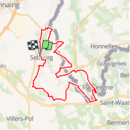
Trail Mountain bike of 34 km to be discovered at Hauts-de-France, Nord, Sebourg. This trail is proposed by tracegps.

Description

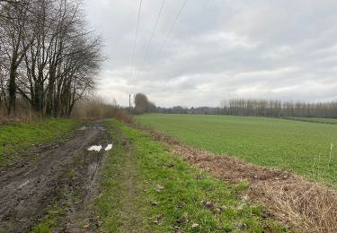
Circuit proposé par le Comité Départemental du Tourisme du Nord. Fiche N° 18 de la pochette « Les circuits VTT du Nord pour la famille et les sportifs » du Comité Départemental du Nord. (22 circuits : 2€) Départ de l’église de Sebourg. Parcours VTT, au cœur de la vallée majeure, sans difficulté hormis la longueur et certains passages boueux en période de pluie. Ce circuit est la variante la plus longue et la plus sportive des options possibles. Les options étant balisées dans les 2 sens, le départ peut se faire depuis n’importe quel village. Retrouvez ce circuit sur le site du Comité Départemental du Tourisme du Nord.

Elevation profile

Photos

Positioning

Country:
France
Region :
Hauts-de-France
Department/Province :
Nord
Municipality :
Sebourg
Location:
Unknown
Start:(UTM)
545885 ; 5576962 (31U) N.

Trails nearby

Trail Walking Honnelles - Cani-Rando au Caillou qui Bique  - Photo
Walking
Pascal Catenne

Walking

Very easy
(1)
Honnelles, Wallonia, Hainaut, Belgium
3.3 km | 4 km-effort
1h 25min
Yes
Trail Walking Estreux - Balade à Estreux  - Photo
Walking
tracegps

Walking

Medium
(1)
Estreux, Hauts-de-France, Nord, France
8.4 km | 9.4 km-effort
2h 10min
Yes
Trail Walking Jenlain - Au départ de Jenlain - Photo
Walking
tracegps

Walking

Medium
(1)
Jenlain, Hauts-de-France, Nord, France
8.4 km | 9.7 km-effort
2h 10min
Yes
Trail Walking Honnelles - Promenade du caillou qui bique  - Photo
Walking
GUIDE+

Walking

Medium
(2)
Honnelles, Wallonia, Hainaut, Belgium
6.5 km | 8.1 km-effort
1h 50min
Yes
Trail Walking Jenlain - Jenlain 20,4 km - Photo
Walking
GUIDE
rvapeldo

Walking

Medium
Jenlain, Hauts-de-France, Nord, France
21 km | 24 km-effort
4h 54min
Yes
Trail Quad Sebourg - Sebourg - Photo
Quad
FRDFC

Quad

Very easy
(1)
Sebourg, Hauts-de-France, Nord, France
120 km | 133 km-effort
Unknown
Yes
Trail Walking Honnelles - les jonquilles au caillou qui bique - Photo
Walking
papiou

Walking

Easy
(2)
Honnelles, Wallonia, Hainaut, Belgium
8.5 km | 10.3 km-effort
2h 6min
Yes
Trail Walking Sebourg - Le Bois de Sebourg - Photo
Walking
corsinou

Walking

Very easy
(1)
Sebourg, Hauts-de-France, Nord, France
6.6 km | 7.7 km-effort
1h 41min
Yes
Trail Walking Honnelles - de Roisin à Villiers Sire Nicole - Photo
Walking
jeff2

Walking

Medium
Honnelles, Wallonia, Hainaut, Belgium
33 km | 37 km-effort
11h 29min
No


Close
My subscriptions