![](/images/other/stat-length.png)
![Trail Walking Fampoux - Des bords de la Scarpe - Fampoux - Photo](https://media.geolcdn.com/t/1900/400/ext.pjpeg?maxdim=2&url=https%3A%2F%2Fservices.sitytrail.com%2FGeolivesWS%2FDownloadMedia.ashx%3FTrailID%3D110055%26Media%3D5164_5.jpg)
Des bords de la Scarpe - Fampoux
tracegps
User
![Length](/images/other/stat-length.png)
Length
9.6 km
![Max alt](https://static1.geolcdn.com/siteimages/upload/files/1508320355ic_sort_altitude_max_24dp.png)
Max alt
80 m
![Uphill gradient](https://static1.geolcdn.com/siteimages/upload/files/1508320355ic_sort_den_pos_24dp.png)
Uphill gradient
65 m
![Km-Effort](/images/other/stat-length.png)
Km-Effort
10.5 km
![Min alt](https://static1.geolcdn.com/siteimages/upload/files/1508320355ic_sort_altitude_min_24dp.png)
Min alt
46 m
![Downhill gradient](https://static1.geolcdn.com/siteimages/upload/files/1508320355ic_sort_den_neg_24dp.png)
Downhill gradient
67 m
![Boucle](https://static1.geolcdn.com/siteimages/upload/files/16400158638029165_repeat_loop_refresh_sync_direction_icon.png)
Boucle
Yes
Creation date :
2014-12-10 00:00:00.0
Updated on :
2014-12-10 00:00:00.0
![Walking](https://static1.geolcdn.com/sitytour/trail-icons/101.png)
2h25
Difficulty : Medium
![Scan this QR Code to open this trail in the SityTrail application](https://capi.geolives.com/qq0zvz2zws4bq2lad0pu/sitytour/trails/110055/qr.png?size=200)
FREE GPS app for hiking
About
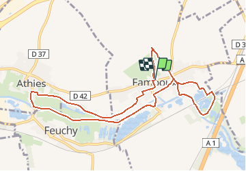
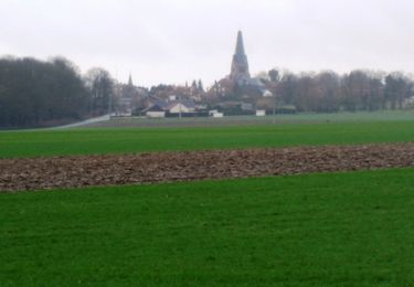
Trail Walking of 9.6 km to be discovered at Hauts-de-France, Pas-de-Calais, Fampoux. This trail is proposed by tracegps.
Description
Circuit proposé par la Communauté Urbaine d’Arras et l’Office de Tourisme d’Arras. Départ de la mairie de Fampoux. Une promenade qui vous entraînera du souvenir du premier conflit mondial à la quiétude des bords de Scarpe. Téléchargez la fiche du circuit.
Positioning
Country:
France
Region :
Hauts-de-France
Department/Province :
Pas-de-Calais
Municipality :
Fampoux
Location:
Unknown
Start:(Dec)
Start:(UTM)
490664 ; 5572279 (31U) N.
Comments
Trails nearby
![Trail Walking Athies - Le chemin du Maresquay - Athies - Photo](https://media.geolcdn.com/t/375/260/ext.jpg?maxdim=2&url=https%3A%2F%2Fservices.sitytrail.com%2FGeolivesWS%2FDownloadMedia.ashx%3FTrailID%3D110048%26Media%3D5157_6.jpg)
![Walking Walking](https://static1.geolcdn.com/sitytour/trail-icons/101.png)
Le chemin du Maresquay - Athies
Walking
Difficult
(1)
Athies,
Hauts-de-France,
Pas-de-Calais,
France
![](/images/other/stat-length.png)
12.9 km | 14.3 km-effort
3h 15min
![](https://static1.geolcdn.com/siteimages/upload/files/16400158638029165_repeat_loop_refresh_sync_direction_icon.png)
Yes
![Trail Walking Monchy-le-Preux - Le chemin du Caribou - Monchy le Preux - Photo](https://media.geolcdn.com/t/375/260/ext.jpg?maxdim=2&url=https%3A%2F%2Fservices.sitytrail.com%2FGeolivesWS%2FDownloadMedia.ashx%3FTrailID%3D109907%26Media%3D4917_5.jpg)
![Walking Walking](https://static1.geolcdn.com/sitytour/trail-icons/101.png)
Le chemin du Caribou - Monchy le Preux
Walking
Medium
(1)
Monchy-le-Preux,
Hauts-de-France,
Pas-de-Calais,
France
![](/images/other/stat-length.png)
9.2 km | 10.1 km-effort
2h 19min
![](https://static1.geolcdn.com/siteimages/upload/files/16400158638029165_repeat_loop_refresh_sync_direction_icon.png)
Yes
![Trail Walking Rœux - De Roeux à Pelves via Monchy-le-Preux - Photo](https://media.geolcdn.com/t/375/260/ext.jpg?maxdim=2&url=https%3A%2F%2Fservices.sitytrail.com%2FGeolivesWS%2FDownloadMedia.ashx%3FTrailID%3D191391%26Media%3D14962_6.jpg)
![Walking Walking](https://static1.geolcdn.com/sitytour/trail-icons/101.png)
De Roeux à Pelves via Monchy-le-Preux
Walking
Medium
Rœux,
Hauts-de-France,
Pas-de-Calais,
France
![](/images/other/stat-length.png)
9.5 km | 10.6 km-effort
2h 30min
![](https://static1.geolcdn.com/siteimages/upload/files/16400158638029165_repeat_loop_refresh_sync_direction_icon.png)
Yes
![Trail Walking Rœux - De Roeux à Plouvain - Photo](https://media.geolcdn.com/t/375/260/ext.jpg?maxdim=2&url=https%3A%2F%2Fservices.sitytrail.com%2FGeolivesWS%2FDownloadMedia.ashx%3FTrailID%3D173057%26Media%3D14581_4.jpg)
![Walking Walking](https://static1.geolcdn.com/sitytour/trail-icons/101.png)
De Roeux à Plouvain
Walking
Easy
Rœux,
Hauts-de-France,
Pas-de-Calais,
France
![](/images/other/stat-length.png)
6.3 km | 6.6 km-effort
1h 34min
![](https://static1.geolcdn.com/siteimages/upload/files/16400158638029165_repeat_loop_refresh_sync_direction_icon.png)
Yes
![Trail Walking Rœux - Lacs et marais - Roeux - Photo](https://media.geolcdn.com/t/375/260/ext.jpg?maxdim=2&url=https%3A%2F%2Fservices.sitytrail.com%2FGeolivesWS%2FDownloadMedia.ashx%3FTrailID%3D172538%26Media%3D13904_6.jpg)
![Walking Walking](https://static1.geolcdn.com/sitytour/trail-icons/101.png)
Lacs et marais - Roeux
Walking
Very difficult
Rœux,
Hauts-de-France,
Pas-de-Calais,
France
![](/images/other/stat-length.png)
18.3 km | 19.6 km-effort
4h 30min
![](https://static1.geolcdn.com/siteimages/upload/files/16400158638029165_repeat_loop_refresh_sync_direction_icon.png)
Yes
![Trail Walking Saint-Laurent-Blangy - Saint Laurent Blangy - Marchiennes en 3 jours - Photo](https://media.geolcdn.com/t/375/260/ext.jpg?maxdim=2&url=https%3A%2F%2Fservices.sitytrail.com%2FGeolivesWS%2FDownloadMedia.ashx%3FTrailID%3D105458%26Media%3D9194_4.jpg)
![Walking Walking](https://static1.geolcdn.com/sitytour/trail-icons/101.png)
Saint Laurent Blangy - Marchiennes en 3 jours
Walking
Difficult
Saint-Laurent-Blangy,
Hauts-de-France,
Pas-de-Calais,
France
![](/images/other/stat-length.png)
66 km | 72 km-effort
17h 0min
![](https://static1.geolcdn.com/siteimages/upload/files/16400158638029165_repeat_loop_refresh_sync_direction_icon.png)
No
![Trail Walking Plouvain - Plouvain le Lac Bleu le marais de Biache Saint Waast - Photo](https://media.geolcdn.com/t/375/260/9480b6fb-3c7e-415c-87b4-6ad5e6fc8a6e.jpg&format=jpg&maxdim=2)
![Walking Walking](https://static1.geolcdn.com/sitytour/trail-icons/101.png)
Plouvain le Lac Bleu le marais de Biache Saint Waast
Walking
Medium
Plouvain,
Hauts-de-France,
Pas-de-Calais,
France
![](/images/other/stat-length.png)
10.3 km | 11.1 km-effort
2h 19min
![](https://static1.geolcdn.com/siteimages/upload/files/16400158638029165_repeat_loop_refresh_sync_direction_icon.png)
Yes
![Trail Walking Monchy-le-Preux - Monchy le Preux - Photo](https://media.geolcdn.com/t/375/260/ext.jpg?maxdim=2&url=https%3A%2F%2Fservices.sitytrail.com%2FGeolivesWS%2FDownloadMedia.ashx%3FTrailID%3D106359%26Media%3D10835_1.jpg)
![Walking Walking](https://static1.geolcdn.com/sitytour/trail-icons/101.png)
Monchy le Preux
Walking
Medium
Monchy-le-Preux,
Hauts-de-France,
Pas-de-Calais,
France
![](/images/other/stat-length.png)
9.7 km | 10.6 km-effort
2h 0min
![](https://static1.geolcdn.com/siteimages/upload/files/16400158638029165_repeat_loop_refresh_sync_direction_icon.png)
Yes
![Trail Walking Pelves - Pelves - Monchy le Preux - Boiry Notre Dame - Photo](https://media.geolcdn.com/t/375/260/ext.jpg?maxdim=2&url=https%3A%2F%2Fservices.sitytrail.com%2FGeolivesWS%2FDownloadMedia.ashx%3FTrailID%3D104118%26Media%3D7188_1.jpg)
![Walking Walking](https://static1.geolcdn.com/sitytour/trail-icons/101.png)
Pelves - Monchy le Preux - Boiry Notre Dame
Walking
Medium
Pelves,
Hauts-de-France,
Pas-de-Calais,
France
![](/images/other/stat-length.png)
9.9 km | 11.2 km-effort
2h 0min
![](https://static1.geolcdn.com/siteimages/upload/files/16400158638029165_repeat_loop_refresh_sync_direction_icon.png)
Yes