![](/images/other/stat-length.png)
![Trail Walking Sainte-Engrâce - Le Canyon d'Ehujarre depuis Sainte-Engrâce - Photo](https://media.geolcdn.com/t/1900/400/ext.pjpeg?maxdim=2&url=https%3A%2F%2Fservices.sitytrail.com%2FGeolivesWS%2FDownloadMedia.ashx%3FTrailID%3D110013%26Media%3D5115_1.jpg)
Le Canyon d'Ehujarre depuis Sainte-Engrâce
tracegps
User
![Length](/images/other/stat-length.png)
![Max alt](https://static1.geolcdn.com/siteimages/upload/files/1508320355ic_sort_altitude_max_24dp.png)
![Uphill gradient](https://static1.geolcdn.com/siteimages/upload/files/1508320355ic_sort_den_pos_24dp.png)
![Km-Effort](/images/other/stat-length.png)
![Min alt](https://static1.geolcdn.com/siteimages/upload/files/1508320355ic_sort_altitude_min_24dp.png)
![Downhill gradient](https://static1.geolcdn.com/siteimages/upload/files/1508320355ic_sort_den_neg_24dp.png)
![Boucle](https://static1.geolcdn.com/siteimages/upload/files/16400158638029165_repeat_loop_refresh_sync_direction_icon.png)
![Walking](https://static1.geolcdn.com/sitytour/trail-icons/101.png)
6h15
Difficulty : Difficult
![Scan this QR Code to open this trail in the SityTrail application](https://capi.geolives.com/qq0zvz2zws4bq2lad0pu/sitytour/trails/110013/qr.png?size=200)
FREE GPS app for hiking
About
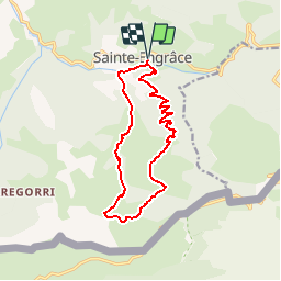
Trail Walking of 14 km to be discovered at New Aquitaine, Pyrénées-Atlantiques, Sainte-Engrâce. This trail is proposed by tracegps.
Description
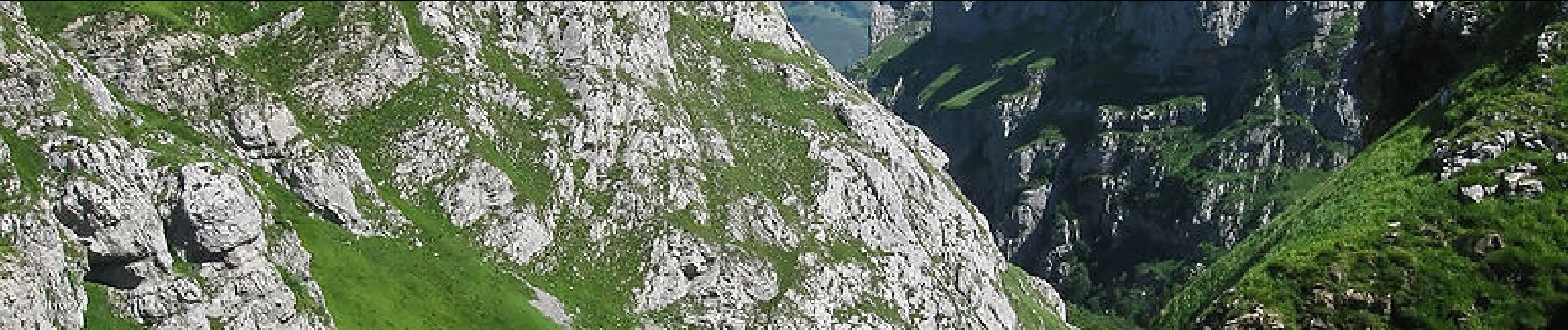
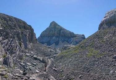
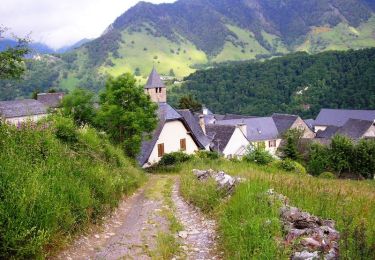
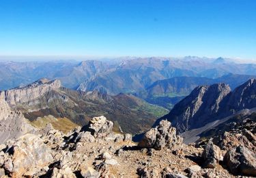
Le Canyon d'Ehujarre depuis Sainte Engrâce (620m) Entaillés dans des calcaires du Crétacé supérieur vieux de 70 millions d'années, les canyon de Haute-Soule figurent en bonne place parmi les merveilles du Pays basque: tous les touristes connaissent Holzarté et Kakueta. Plus à l'Est, sauvage, grandiose et solitaire, Ehujarre (ou Uhaitzarre) est une fantastique entaille pour les visiteurs depuis le site de Sainte Engrâce-Eglise soit en circuit, soit en aller retour. D’autres indications, photos et panoramiques sur le site « Les Pyrénées vues par Mariano ».
Positioning
Comments
Trails nearby
![Trail On foot Lanne-en-Barétous - ISSARBE les crêtes 2893126 - Photo](https://media.geolcdn.com/t/375/260/755218ac-9ef4-4c72-9363-0dc6b489c5da.jpg&format=jpg&maxdim=2)
![On foot On foot](https://static1.geolcdn.com/sitytour/trail-icons/100.png)
On foot
![](/images/other/stat-length.png)
![](https://static1.geolcdn.com/siteimages/upload/files/16400158638029165_repeat_loop_refresh_sync_direction_icon.png)
![Trail Walking Arette - GR 10 - 12ème etape - Arette -La Pierre-st-Matin - Le refuge de l’Abérouat - Lescun - Photo](https://media.geolcdn.com/t/375/260/ef455401-c2e2-4a88-bda3-f460b6d8e990.jpg&format=jpg&maxdim=2)
![Walking Walking](https://static1.geolcdn.com/sitytour/trail-icons/101.png)
Walking
![](/images/other/stat-length.png)
![](https://static1.geolcdn.com/siteimages/upload/files/16400158638029165_repeat_loop_refresh_sync_direction_icon.png)
![Trail Walking Sainte-Engrâce - GR 10 - 11ème étape : Sainte Engrâce -refuge La Pierre-Szint-Martin - Photo](https://media.geolcdn.com/t/375/260/5c0e4576-1fda-46f9-a677-2b511e293c76.jpg&format=jpg&maxdim=2)
![Walking Walking](https://static1.geolcdn.com/sitytour/trail-icons/101.png)
Walking
![](/images/other/stat-length.png)
![](https://static1.geolcdn.com/siteimages/upload/files/16400158638029165_repeat_loop_refresh_sync_direction_icon.png)
![Walking Walking](https://static1.geolcdn.com/sitytour/trail-icons/101.png)
Walking
![](/images/other/stat-length.png)
![](https://static1.geolcdn.com/siteimages/upload/files/16400158638029165_repeat_loop_refresh_sync_direction_icon.png)
![Trail Other activity Sainte-Engrâce - TDP N°9 STE EN GRÂCE ARÊTE LA PIERRE ST MARTIN - Photo](https://media.geolcdn.com/t/375/260/ext.jpg?maxdim=2&url=https%3A%2F%2Fservices.sitytrail.com%2FGeolivesWS%2FDownloadMedia.ashx%3FTrailID%3D751606%26Media%3Dfix__20170511123156.jpg)
![Other activity Other activity](https://static1.geolcdn.com/sitytour/trail-icons/900.png)
Other activity
![](/images/other/stat-length.png)
![](https://static1.geolcdn.com/siteimages/upload/files/16400158638029165_repeat_loop_refresh_sync_direction_icon.png)
![Trail Walking Arette - La Pierre St Martin à Lescun - Photo](https://media.geolcdn.com/t/375/260/ext.jpg?maxdim=2&url=https%3A%2F%2Fservices.sitytrail.com%2FGeolivesWS%2FDownloadMedia.ashx%3FTrailID%3D109452%26Media%3D3904_4.jpg)
![Walking Walking](https://static1.geolcdn.com/sitytour/trail-icons/101.png)
Walking
![](/images/other/stat-length.png)
![](https://static1.geolcdn.com/siteimages/upload/files/16400158638029165_repeat_loop_refresh_sync_direction_icon.png)
![Trail Walking Sainte-Engrâce - st-engrace-Gorges-D'Ehujarre - Photo](https://media.geolcdn.com/t/375/260/f128e555-5abd-40fc-a180-29140085bec2.jpg&format=jpg&maxdim=2)
![Walking Walking](https://static1.geolcdn.com/sitytour/trail-icons/101.png)
Walking
![](/images/other/stat-length.png)
![](https://static1.geolcdn.com/siteimages/upload/files/16400158638029165_repeat_loop_refresh_sync_direction_icon.png)
![Trail On foot Arette - SityTrail - LPSM en boucle](https://media.geolcdn.com/t/375/260/ext.jpg?maxdim=2&url=https%3A%2F%2Fstatic1.geolcdn.com%2Fsiteimages%2Fupload%2Ffiles%2F1545311037marcheuse_200dpi.jpg)
![On foot On foot](https://static1.geolcdn.com/sitytour/trail-icons/100.png)
On foot
![](/images/other/stat-length.png)
![](https://static1.geolcdn.com/siteimages/upload/files/16400158638029165_repeat_loop_refresh_sync_direction_icon.png)
![Trail Walking Arette - Pic d'Anie 2504m depuis La Pierre Saint Martin - Photo](https://media.geolcdn.com/t/375/260/ext.jpg?maxdim=2&url=https%3A%2F%2Fservices.sitytrail.com%2FGeolivesWS%2FDownloadMedia.ashx%3FTrailID%3D109911%26Media%3D4925_1.jpg)
![Walking Walking](https://static1.geolcdn.com/sitytour/trail-icons/101.png)
Walking
![](/images/other/stat-length.png)
![](https://static1.geolcdn.com/siteimages/upload/files/16400158638029165_repeat_loop_refresh_sync_direction_icon.png)