![](/images/other/stat-length.png)
![Trail Cycle Ailly-sur-Noye - Le Val de Noye - Boucle de Coullemelle - Photo](https://media.geolcdn.com/t/1900/400/ext.pjpeg?maxdim=2&url=https%3A%2F%2Fservices.sitytrail.com%2FGeolivesWS%2FDownloadMedia.ashx%3FTrailID%3D109971%26Media%3D5052_1.jpg)
Le Val de Noye - Boucle de Coullemelle
tracegps
User
![Length](/images/other/stat-length.png)
Length
33 km
![Max alt](https://static1.geolcdn.com/siteimages/upload/files/1508320355ic_sort_altitude_max_24dp.png)
Max alt
156 m
![Uphill gradient](https://static1.geolcdn.com/siteimages/upload/files/1508320355ic_sort_den_pos_24dp.png)
Uphill gradient
352 m
![Km-Effort](/images/other/stat-length.png)
Km-Effort
38 km
![Min alt](https://static1.geolcdn.com/siteimages/upload/files/1508320355ic_sort_altitude_min_24dp.png)
Min alt
48 m
![Downhill gradient](https://static1.geolcdn.com/siteimages/upload/files/1508320355ic_sort_den_neg_24dp.png)
Downhill gradient
350 m
![Boucle](https://static1.geolcdn.com/siteimages/upload/files/16400158638029165_repeat_loop_refresh_sync_direction_icon.png)
Boucle
Yes
Creation date :
2014-12-10 00:00:00.0
Updated on :
2014-12-10 00:00:00.0
![Cycle](https://static1.geolcdn.com/sitytour/trail-icons/200.png)
2h00
Difficulty : Medium
![Scan this QR Code to open this trail in the SityTrail application](https://capi.geolives.com/qq0zvz2zws4bq2lad0pu/sitytour/trails/109971/qr.png?size=200)
FREE GPS app for hiking
About
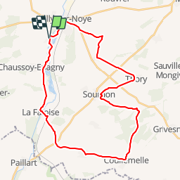
Trail Cycle of 33 km to be discovered at Hauts-de-France, Somme, Ailly-sur-Noye. This trail is proposed by tracegps.
Description
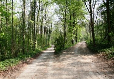
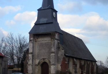
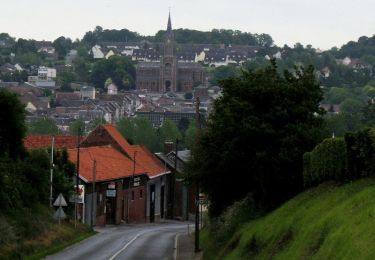
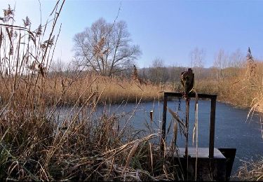
Le Val de Noye - Boucle de Coullemelle Une boucle à la découverte d’une très jolie vallée enchâssée dans un écrin de verdure avec étangs et peupleraies. À voir ; Vallée de la Noye : nombreux étangs.
Positioning
Country:
France
Region :
Hauts-de-France
Department/Province :
Somme
Municipality :
Ailly-sur-Noye
Location:
Unknown
Start:(Dec)
Start:(UTM)
453118 ; 5510511 (31U) N.
Comments
Trails nearby
![Trail Walking Remiencourt - Le bois du Roi - Photo](https://media.geolcdn.com/t/375/260/ext.jpg?maxdim=2&url=https%3A%2F%2Fservices.sitytrail.com%2FGeolivesWS%2FDownloadMedia.ashx%3FTrailID%3D108859%26Media%3D2403_2.jpg)
![Walking Walking](https://static1.geolcdn.com/sitytour/trail-icons/101.png)
Le bois du Roi
Walking
Difficult
(1)
Remiencourt,
Hauts-de-France,
Somme,
France
![](/images/other/stat-length.png)
12.4 km | 15.2 km-effort
4h 0min
![](https://static1.geolcdn.com/siteimages/upload/files/16400158638029165_repeat_loop_refresh_sync_direction_icon.png)
Yes
![Trail Walking Remiencourt - le bois du roi Remiencourt 80 - Photo](https://media.geolcdn.com/t/375/260/bc50bb6a-30a4-4e52-8497-2c709f5b6312.jpg&format=jpg&maxdim=2)
![Walking Walking](https://static1.geolcdn.com/sitytour/trail-icons/101.png)
le bois du roi Remiencourt 80
Walking
Medium
Remiencourt,
Hauts-de-France,
Somme,
France
![](/images/other/stat-length.png)
12.7 km | 15.4 km-effort
3h 10min
![](https://static1.geolcdn.com/siteimages/upload/files/16400158638029165_repeat_loop_refresh_sync_direction_icon.png)
Yes
![Trail Walking Ailly-sur-Noye - Bois de Berny - Photo](https://media.geolcdn.com/t/375/260/ext.jpg?maxdim=2&url=https%3A%2F%2Fstatic1.geolcdn.com%2Fsiteimages%2Fupload%2Ffiles%2F1553511878bg_sport_marche.png)
![Walking Walking](https://static1.geolcdn.com/sitytour/trail-icons/101.png)
Bois de Berny
Walking
Medium
(1)
Ailly-sur-Noye,
Hauts-de-France,
Somme,
France
![](/images/other/stat-length.png)
10.1 km | 12.1 km-effort
2h 38min
![](https://static1.geolcdn.com/siteimages/upload/files/16400158638029165_repeat_loop_refresh_sync_direction_icon.png)
Yes
![Trail Walking Sourdon - Autour d'Ainval - Sourdon - Photo](https://media.geolcdn.com/t/375/260/ext.jpg?maxdim=2&url=https%3A%2F%2Fservices.sitytrail.com%2FGeolivesWS%2FDownloadMedia.ashx%3FTrailID%3D316957%26Media%3D16075_4.jpg)
![Walking Walking](https://static1.geolcdn.com/sitytour/trail-icons/101.png)
Autour d'Ainval - Sourdon
Walking
Medium
Sourdon,
Hauts-de-France,
Somme,
France
![](/images/other/stat-length.png)
10.4 km | 12.3 km-effort
3h 0min
![](https://static1.geolcdn.com/siteimages/upload/files/16400158638029165_repeat_loop_refresh_sync_direction_icon.png)
Yes
![Trail Walking Grattepanche - Grattepanche-Absous-Larris - Photo](https://media.geolcdn.com/t/375/260/ext.jpg?maxdim=2&url=https%3A%2F%2Fstatic1.geolcdn.com%2Fsiteimages%2Fupload%2Ffiles%2F1553511878bg_sport_marche.png)
![Walking Walking](https://static1.geolcdn.com/sitytour/trail-icons/101.png)
Grattepanche-Absous-Larris
Walking
Difficult
(1)
Grattepanche,
Hauts-de-France,
Somme,
France
![](/images/other/stat-length.png)
11 km | 13 km-effort
2h 51min
![](https://static1.geolcdn.com/siteimages/upload/files/16400158638029165_repeat_loop_refresh_sync_direction_icon.png)
Yes
![Trail On foot Grattepanche - La Montagne des Grès - Photo](https://media.geolcdn.com/t/375/260/6ef53137-0400-4626-9dd4-c31a6d8d7c2e.jpeg&format=jpg&maxdim=2)
![On foot On foot](https://static1.geolcdn.com/sitytour/trail-icons/100.png)
La Montagne des Grès
On foot
Easy
Grattepanche,
Hauts-de-France,
Somme,
France
![](/images/other/stat-length.png)
3.9 km | 4.8 km-effort
1h 5min
![](https://static1.geolcdn.com/siteimages/upload/files/16400158638029165_repeat_loop_refresh_sync_direction_icon.png)
No
![Trail Other activity Ailly-sur-Noye - f - Photo](https://media.geolcdn.com/t/375/260/ext.jpg?maxdim=2&url=https%3A%2F%2Fservices.sitytrail.com%2FGeolivesWS%2FDownloadMedia.ashx%3FTrailID%3D227421%26Media%3Dfix__20131016151534.jpg)
![Other activity Other activity](https://static1.geolcdn.com/sitytour/trail-icons/900.png)
f
Other activity
Very easy
Ailly-sur-Noye,
Hauts-de-France,
Somme,
France
![](/images/other/stat-length.png)
18.8 km | 22 km-effort
2h 3min
![](https://static1.geolcdn.com/siteimages/upload/files/16400158638029165_repeat_loop_refresh_sync_direction_icon.png)
Yes
![Trail Mountain bike Ailly-sur-Noye - Circuit n° 4 VTT - Ailly-sur-Noye - Photo](https://media.geolcdn.com/t/375/260/ext.jpg?maxdim=2&url=https%3A%2F%2Fservices.sitytrail.com%2FGeolivesWS%2FDownloadMedia.ashx%3FTrailID%3D111125%26Media%3D6480_2.jpg)
![Mountain bike Mountain bike](https://static1.geolcdn.com/sitytour/trail-icons/202.png)
Circuit n° 4 VTT - Ailly-sur-Noye
Mountain bike
Difficult
Ailly-sur-Noye,
Hauts-de-France,
Somme,
France
![](/images/other/stat-length.png)
42 km | 50 km-effort
4h 0min
![](https://static1.geolcdn.com/siteimages/upload/files/16400158638029165_repeat_loop_refresh_sync_direction_icon.png)
Yes
![Trail Cycle Ailly-sur-Noye - Le Val de Noye - Boucle de Boves - Photo](https://media.geolcdn.com/t/375/260/ext.jpg?maxdim=2&url=https%3A%2F%2Fservices.sitytrail.com%2FGeolivesWS%2FDownloadMedia.ashx%3FTrailID%3D109972%26Media%3D5053_1.jpg)
![Cycle Cycle](https://static1.geolcdn.com/sitytour/trail-icons/200.png)
Le Val de Noye - Boucle de Boves
Cycle
Medium
Ailly-sur-Noye,
Hauts-de-France,
Somme,
France
![](/images/other/stat-length.png)
27 km | 30 km-effort
1h 30min
![](https://static1.geolcdn.com/siteimages/upload/files/16400158638029165_repeat_loop_refresh_sync_direction_icon.png)
Yes