![](/images/other/stat-length.png)
![Trail Walking Saint-Christophe-en-Oisans - Tour Gourmand de Saint Christophe en Oisans - Jour 4 - Photo](https://media.geolcdn.com/t/1900/400/ext.pjpeg?maxdim=2&url=https%3A%2F%2Fservices.sitytrail.com%2FGeolivesWS%2FDownloadMedia.ashx%3FTrailID%3D109941%26Media%3D4998_1.jpg)
Tour Gourmand de Saint Christophe en Oisans - Jour 4
tracegps
User
![Length](/images/other/stat-length.png)
Length
8.7 km
![Max alt](https://static1.geolcdn.com/siteimages/upload/files/1508320355ic_sort_altitude_max_24dp.png)
Max alt
2563 m
![Uphill gradient](https://static1.geolcdn.com/siteimages/upload/files/1508320355ic_sort_den_pos_24dp.png)
Uphill gradient
993 m
![Km-Effort](/images/other/stat-length.png)
Km-Effort
22 km
![Min alt](https://static1.geolcdn.com/siteimages/upload/files/1508320355ic_sort_altitude_min_24dp.png)
Min alt
1565 m
![Downhill gradient](https://static1.geolcdn.com/siteimages/upload/files/1508320355ic_sort_den_neg_24dp.png)
Downhill gradient
978 m
![Boucle](https://static1.geolcdn.com/siteimages/upload/files/16400158638029165_repeat_loop_refresh_sync_direction_icon.png)
Boucle
No
Creation date :
2014-12-10 00:00:00.0
Updated on :
2014-12-10 00:00:00.0
![Walking](https://static1.geolcdn.com/sitytour/trail-icons/101.png)
5h00
Difficulty : Difficult
![Scan this QR Code to open this trail in the SityTrail application](https://capi.geolives.com/qq0zvz2zws4bq2lad0pu/sitytour/trails/109941/qr.png?size=200)
FREE GPS app for hiking
About
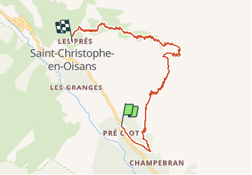
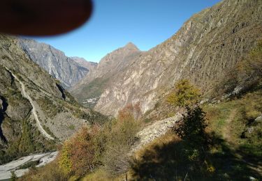
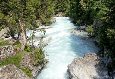
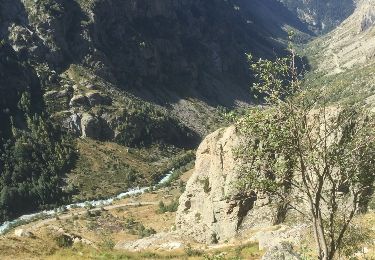
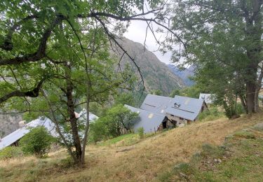
Trail Walking of 8.7 km to be discovered at Auvergne-Rhône-Alpes, Isère, Saint-Christophe-en-Oisans. This trail is proposed by tracegps.
Description
Tour gourmand de Saint Christophe en Oisans – Jour 4 Départ pour le Plat de la Selle et St Christophe. 5h de marche/1016 m / Repas et nuit en chambre à l'Hôtel de la Cordée ou à La Table du Christolet. "Les crozets de Marie Claude ou Tourte aux herbes".
Positioning
Country:
France
Region :
Auvergne-Rhône-Alpes
Department/Province :
Isère
Municipality :
Saint-Christophe-en-Oisans
Location:
Unknown
Start:(Dec)
Start:(UTM)
278210 ; 4980798 (32T) N.
Comments
Trails nearby
![Trail Walking Saint-Christophe-en-Oisans - 0isans - Vénéon - du gîte du Plan du lac au Pont des Granges - AR - Photo](https://media.geolcdn.com/t/375/260/ext.jpg?maxdim=2&url=https%3A%2F%2Fservices.sitytrail.com%2FGeolivesWS%2FDownloadMedia.ashx%3FTrailID%3D440124%26Media%3Dfix__20150626103336.jpg)
![Walking Walking](https://static1.geolcdn.com/sitytour/trail-icons/101.png)
0isans - Vénéon - du gîte du Plan du lac au Pont des Granges - AR
Walking
Medium
Saint-Christophe-en-Oisans,
Auvergne-Rhône-Alpes,
Isère,
France
![](/images/other/stat-length.png)
8.4 km | 11.6 km-effort
4h 15min
![](https://static1.geolcdn.com/siteimages/upload/files/16400158638029165_repeat_loop_refresh_sync_direction_icon.png)
Yes
![Trail Walking Saint-Christophe-en-Oisans - Oisans - Vénéon - La Lavey - Photo](https://media.geolcdn.com/t/375/260/ext.jpg?maxdim=2&url=https%3A%2F%2Fservices.sitytrail.com%2FGeolivesWS%2FDownloadMedia.ashx%3FTrailID%3D440118%26Media%3Dfix__20150624154321.jpg)
![Walking Walking](https://static1.geolcdn.com/sitytour/trail-icons/101.png)
Oisans - Vénéon - La Lavey
Walking
Difficult
Saint-Christophe-en-Oisans,
Auvergne-Rhône-Alpes,
Isère,
France
![](/images/other/stat-length.png)
12.9 km | 21 km-effort
5h 40min
![](https://static1.geolcdn.com/siteimages/upload/files/16400158638029165_repeat_loop_refresh_sync_direction_icon.png)
Yes
![Trail Walking Saint-Christophe-en-Oisans - Oisans - Vénéon - Vallon de Lanchâtra - Photo](https://media.geolcdn.com/t/375/260/ext.jpg?maxdim=2&url=https%3A%2F%2Fservices.sitytrail.com%2FGeolivesWS%2FDownloadMedia.ashx%3FTrailID%3D435411%26Media%3Dfix__20150618132240.jpg)
![Walking Walking](https://static1.geolcdn.com/sitytour/trail-icons/101.png)
Oisans - Vénéon - Vallon de Lanchâtra
Walking
Difficult
Saint-Christophe-en-Oisans,
Auvergne-Rhône-Alpes,
Isère,
France
![](/images/other/stat-length.png)
12.6 km | 24 km-effort
6h 5min
![](https://static1.geolcdn.com/siteimages/upload/files/16400158638029165_repeat_loop_refresh_sync_direction_icon.png)
Yes
![Trail Walking Saint-Christophe-en-Oisans - Lac des Bèches - Photo](https://media.geolcdn.com/t/375/260/aed396ac-ba2f-4a61-b7da-cb061c5fa992.jpg&format=jpg&maxdim=2)
![Walking Walking](https://static1.geolcdn.com/sitytour/trail-icons/101.png)
Lac des Bèches
Walking
Very difficult
Saint-Christophe-en-Oisans,
Auvergne-Rhône-Alpes,
Isère,
France
![](/images/other/stat-length.png)
16 km | 31 km-effort
6h 33min
![](https://static1.geolcdn.com/siteimages/upload/files/16400158638029165_repeat_loop_refresh_sync_direction_icon.png)
Yes
![Trail Walking Saint-Christophe-en-Oisans - Le Refuge de La Lavey - Photo](https://media.geolcdn.com/t/375/260/93f33870-82da-46b6-b914-d8870ae2198e.jpg&format=jpg&maxdim=2)
![Walking Walking](https://static1.geolcdn.com/sitytour/trail-icons/101.png)
Le Refuge de La Lavey
Walking
Medium
Saint-Christophe-en-Oisans,
Auvergne-Rhône-Alpes,
Isère,
France
![](/images/other/stat-length.png)
12.2 km | 20 km-effort
5h 52min
![](https://static1.geolcdn.com/siteimages/upload/files/16400158638029165_repeat_loop_refresh_sync_direction_icon.png)
Yes
![Trail Walking Les Deux Alpes - BOUCLE DU VENEON - Photo](https://media.geolcdn.com/t/375/260/fb72e059-97b0-4c6d-b32f-a72bcc6ce0d2.jpg&format=jpg&maxdim=2)
![Walking Walking](https://static1.geolcdn.com/sitytour/trail-icons/101.png)
BOUCLE DU VENEON
Walking
Difficult
Les Deux Alpes,
Auvergne-Rhône-Alpes,
Isère,
France
![](/images/other/stat-length.png)
12.5 km | 22 km-effort
5h 9min
![](https://static1.geolcdn.com/siteimages/upload/files/16400158638029165_repeat_loop_refresh_sync_direction_icon.png)
Yes
![Trail Walking Saint-Christophe-en-Oisans - Oisans - Champhorent - 5.3km 210m 1h40 - 2018 06 17 - public - Photo](https://media.geolcdn.com/t/375/260/ext.jpg?maxdim=2&url=https%3A%2F%2Fservices.sitytrail.com%2FGeolivesWS%2FDownloadMedia.ashx%3FTrailID%3D999394%26Media%3Dfix__20180617110737.jpg)
![Walking Walking](https://static1.geolcdn.com/sitytour/trail-icons/101.png)
Oisans - Champhorent - 5.3km 210m 1h40 - 2018 06 17 - public
Walking
Medium
Saint-Christophe-en-Oisans,
Auvergne-Rhône-Alpes,
Isère,
France
![](/images/other/stat-length.png)
5.3 km | 8.1 km-effort
2h 15min
![](https://static1.geolcdn.com/siteimages/upload/files/16400158638029165_repeat_loop_refresh_sync_direction_icon.png)
Yes
![Trail Walking Saint-Christophe-en-Oisans - RETOUR du REFUGE DU SOREILLER-09-09-2016 - Photo](https://media.geolcdn.com/t/375/260/ext.jpg?maxdim=2&url=https%3A%2F%2Fservices.sitytrail.com%2FGeolivesWS%2FDownloadMedia.ashx%3FTrailID%3D630349%26Media%3D20160909111903.jpg)
![Walking Walking](https://static1.geolcdn.com/sitytour/trail-icons/101.png)
RETOUR du REFUGE DU SOREILLER-09-09-2016
Walking
Medium
Saint-Christophe-en-Oisans,
Auvergne-Rhône-Alpes,
Isère,
France
![](/images/other/stat-length.png)
5.6 km | 9.6 km-effort
3h 2min
![](https://static1.geolcdn.com/siteimages/upload/files/16400158638029165_repeat_loop_refresh_sync_direction_icon.png)
No
![Trail Walking Les Deux Alpes - st crhistophe en oisan - Photo](https://media.geolcdn.com/t/375/260/d758f3a0-82c5-4f8a-903f-6c6616dd8ce8.jpg&format=jpg&maxdim=2)
![Walking Walking](https://static1.geolcdn.com/sitytour/trail-icons/101.png)
st crhistophe en oisan
Walking
Medium
Les Deux Alpes,
Auvergne-Rhône-Alpes,
Isère,
France
![](/images/other/stat-length.png)
11.5 km | 19.2 km-effort
3h 55min
![](https://static1.geolcdn.com/siteimages/upload/files/16400158638029165_repeat_loop_refresh_sync_direction_icon.png)
Yes