![](/images/other/stat-length.png)
![Trail Cycle Abbeville - L'Abbevillois - Photo](https://media.geolcdn.com/t/1900/400/ext.pjpeg?maxdim=2&url=https%3A%2F%2Fservices.sitytrail.com%2FGeolivesWS%2FDownloadMedia.ashx%3FTrailID%3D109920%26Media%3D4937_1.jpg)
L'Abbevillois
tracegps
User
![Length](/images/other/stat-length.png)
Length
51 km
![Max alt](https://static1.geolcdn.com/siteimages/upload/files/1508320355ic_sort_altitude_max_24dp.png)
Max alt
112 m
![Uphill gradient](https://static1.geolcdn.com/siteimages/upload/files/1508320355ic_sort_den_pos_24dp.png)
Uphill gradient
594 m
![Km-Effort](/images/other/stat-length.png)
Km-Effort
59 km
![Min alt](https://static1.geolcdn.com/siteimages/upload/files/1508320355ic_sort_altitude_min_24dp.png)
Min alt
3 m
![Downhill gradient](https://static1.geolcdn.com/siteimages/upload/files/1508320355ic_sort_den_neg_24dp.png)
Downhill gradient
593 m
![Boucle](https://static1.geolcdn.com/siteimages/upload/files/16400158638029165_repeat_loop_refresh_sync_direction_icon.png)
Boucle
Yes
Creation date :
2014-12-10 00:00:00.0
Updated on :
2014-12-10 00:00:00.0
![Cycle](https://static1.geolcdn.com/sitytour/trail-icons/200.png)
3h00
Difficulty : Difficult
![Scan this QR Code to open this trail in the SityTrail application](https://capi.geolives.com/qq0zvz2zws4bq2lad0pu/sitytour/trails/109920/qr.png?size=200)
FREE GPS app for hiking
About
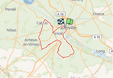
Trail Cycle of 51 km to be discovered at Hauts-de-France, Somme, Abbeville. This trail is proposed by tracegps.
Description
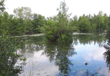
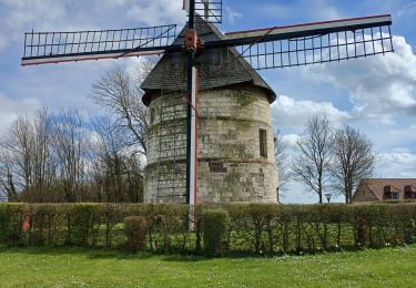
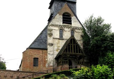
L’Abbevillois Un circuit au départ de la gare d’Abbeville qui vous fera découvrir des paysages surprenant sur le Vimeu mais aussi sur la vallée de la Somme Départ : parking de la gare SNCF d’Abbeville.
Positioning
Country:
France
Region :
Hauts-de-France
Department/Province :
Somme
Municipality :
Abbeville
Location:
Unknown
Start:(Dec)
Start:(UTM)
416011 ; 5550764 (31U) N.
Comments
Trails nearby
![Trail Walking Yonval - Les 3 Fétus - Yonval - Photo](https://media.geolcdn.com/t/375/260/ext.jpg?maxdim=2&url=https%3A%2F%2Fservices.sitytrail.com%2FGeolivesWS%2FDownloadMedia.ashx%3FTrailID%3D108581%26Media%3D1489_1.jpg)
![Walking Walking](https://static1.geolcdn.com/sitytour/trail-icons/101.png)
Les 3 Fétus - Yonval
Walking
Difficult
(2)
Yonval,
Hauts-de-France,
Somme,
France
![](/images/other/stat-length.png)
7.5 km | 9.4 km-effort
2h 30min
![](https://static1.geolcdn.com/siteimages/upload/files/16400158638029165_repeat_loop_refresh_sync_direction_icon.png)
Yes
![Trail On foot Eaucourt-sur-Somme - Le Moulin d'Eaucourt - Photo](https://media.geolcdn.com/t/375/260/9b9489ba-5456-4746-a4ec-6f9e1c594e14.jpeg&format=jpg&maxdim=2)
![On foot On foot](https://static1.geolcdn.com/sitytour/trail-icons/100.png)
Le Moulin d'Eaucourt
On foot
Easy
Eaucourt-sur-Somme,
Hauts-de-France,
Somme,
France
![](/images/other/stat-length.png)
5.8 km | 7.3 km-effort
1h 39min
![](https://static1.geolcdn.com/siteimages/upload/files/16400158638029165_repeat_loop_refresh_sync_direction_icon.png)
Yes
![Trail Walking Eaucourt-sur-Somme - le moulin d'Eaucourt - Photo](https://media.geolcdn.com/t/375/260/4264d59a-a879-4d1d-a4fc-208df5e572be.jpg&format=jpg&maxdim=2)
![Walking Walking](https://static1.geolcdn.com/sitytour/trail-icons/101.png)
le moulin d'Eaucourt
Walking
Easy
Eaucourt-sur-Somme,
Hauts-de-France,
Somme,
France
![](/images/other/stat-length.png)
7.4 km | 9.1 km-effort
2h 23min
![](https://static1.geolcdn.com/siteimages/upload/files/16400158638029165_repeat_loop_refresh_sync_direction_icon.png)
Yes
![Trail Walking Mareuil-Caubert - Au travers des étangs - Photo](https://media.geolcdn.com/t/375/260/3d0ba1a8-2447-466c-a227-2f133fd97408.jpg&format=jpg&maxdim=2)
![Walking Walking](https://static1.geolcdn.com/sitytour/trail-icons/101.png)
Au travers des étangs
Walking
Very easy
Mareuil-Caubert,
Hauts-de-France,
Somme,
France
![](/images/other/stat-length.png)
3.7 km | 3.9 km-effort
1h 16min
![](https://static1.geolcdn.com/siteimages/upload/files/16400158638029165_repeat_loop_refresh_sync_direction_icon.png)
Yes
![Trail Cycle Abbeville - la baie de Somme à vélo - Photo](https://media.geolcdn.com/t/375/260/ext.jpg?maxdim=2&url=https%3A%2F%2Fservices.sitytrail.com%2FGeolivesWS%2FDownloadMedia.ashx%3FTrailID%3D1132041%26Media%3D20190407095358.jpg)
![Cycle Cycle](https://static1.geolcdn.com/sitytour/trail-icons/200.png)
la baie de Somme à vélo
Cycle
Very easy
Abbeville,
Hauts-de-France,
Somme,
France
![](/images/other/stat-length.png)
118 km | 124 km-effort
8h 12min
![](https://static1.geolcdn.com/siteimages/upload/files/16400158638029165_repeat_loop_refresh_sync_direction_icon.png)
No
![Trail Walking Abbeville - Abbeville chemin du Pâtis - Photo](https://media.geolcdn.com/t/375/260/ba947a24-30d5-4d85-9868-f6de26ac7666.jpg&format=jpg&maxdim=2)
![Walking Walking](https://static1.geolcdn.com/sitytour/trail-icons/101.png)
Abbeville chemin du Pâtis
Walking
Easy
Abbeville,
Hauts-de-France,
Somme,
France
![](/images/other/stat-length.png)
14 km | 15 km-effort
4h 6min
![](https://static1.geolcdn.com/siteimages/upload/files/16400158638029165_repeat_loop_refresh_sync_direction_icon.png)
No
![Trail Walking Eaucourt-sur-Somme - lp80_eaucourt - Photo](https://media.geolcdn.com/t/375/260/9ce553b3-b2ee-49ec-b994-ab1db0443503.jpg&format=jpg&maxdim=2)
![Walking Walking](https://static1.geolcdn.com/sitytour/trail-icons/101.png)
lp80_eaucourt
Walking
Medium
Eaucourt-sur-Somme,
Hauts-de-France,
Somme,
France
![](/images/other/stat-length.png)
7.2 km | 8.9 km-effort
2h 1min
![](https://static1.geolcdn.com/siteimages/upload/files/16400158638029165_repeat_loop_refresh_sync_direction_icon.png)
Yes
![Trail Walking Abbeville - Abbeville Grands Lavier - Photo](https://media.geolcdn.com/t/375/260/978d0648-091c-45aa-876f-de0aec8e1ab5.jpg&format=jpg&maxdim=2)
![Walking Walking](https://static1.geolcdn.com/sitytour/trail-icons/101.png)
Abbeville Grands Lavier
Walking
Very easy
Abbeville,
Hauts-de-France,
Somme,
France
![](/images/other/stat-length.png)
17.7 km | 18.6 km-effort
4h 40min
![](https://static1.geolcdn.com/siteimages/upload/files/16400158638029165_repeat_loop_refresh_sync_direction_icon.png)
No
![Trail On foot Mareuil-Caubert - La Vallée de Frosme - Photo](https://media.geolcdn.com/t/375/260/cf87097c-bd8e-42ef-880c-3a413e4f1840.jpeg&format=jpg&maxdim=2)
![On foot On foot](https://static1.geolcdn.com/sitytour/trail-icons/100.png)
La Vallée de Frosme
On foot
Easy
Mareuil-Caubert,
Hauts-de-France,
Somme,
France
![](/images/other/stat-length.png)
9.1 km | 11.5 km-effort
2h 37min
![](https://static1.geolcdn.com/siteimages/upload/files/16400158638029165_repeat_loop_refresh_sync_direction_icon.png)
Yes