![](/images/other/stat-length.png)
![Trail Cycle Abbeville - La Traverse du Ponthieu - Abbeville - Photo](https://media.geolcdn.com/t/1900/400/ext.pjpeg?maxdim=2&url=https%3A%2F%2Fservices.sitytrail.com%2FGeolivesWS%2FDownloadMedia.ashx%3FTrailID%3D109917%26Media%3D4932_1.jpg)
La Traverse du Ponthieu - Abbeville
tracegps
User
![Length](/images/other/stat-length.png)
![Max alt](https://static1.geolcdn.com/siteimages/upload/files/1508320355ic_sort_altitude_max_24dp.png)
![Uphill gradient](https://static1.geolcdn.com/siteimages/upload/files/1508320355ic_sort_den_pos_24dp.png)
![Km-Effort](/images/other/stat-length.png)
![Min alt](https://static1.geolcdn.com/siteimages/upload/files/1508320355ic_sort_altitude_min_24dp.png)
![Downhill gradient](https://static1.geolcdn.com/siteimages/upload/files/1508320355ic_sort_den_neg_24dp.png)
![Boucle](https://static1.geolcdn.com/siteimages/upload/files/16400158638029165_repeat_loop_refresh_sync_direction_icon.png)
![Cycle](https://static1.geolcdn.com/sitytour/trail-icons/200.png)
1h30
Difficulty : Easy
![Scan this QR Code to open this trail in the SityTrail application](https://capi.geolives.com/qq0zvz2zws4bq2lad0pu/sitytour/trails/109917/qr.png?size=200)
FREE GPS app for hiking
About
Trail Cycle of 28 km to be discovered at Hauts-de-France, Somme, Abbeville. This trail is proposed by tracegps.
Description
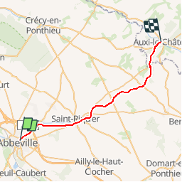
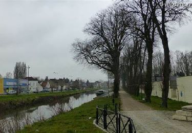
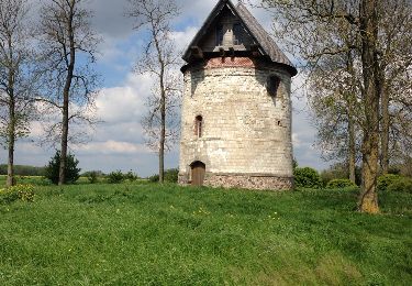
La Traverse du Ponthieu Un itinéraire sur les traces des trains qui, durant plus d’un siècle, quittèrent la capitale du Ponthieu pour traverser la campagne. Départ : Abbeville, parking de la piscine. Disparue depuis 1998, cette ancienne voie ferrée a été réhabilitée pour permettre à tous les randonneurs de relier Auxi-le-Château à Abbeville.
Positioning
Comments
Trails nearby
![Trail Walking Yonval - Les 3 Fétus - Yonval - Photo](https://media.geolcdn.com/t/375/260/ext.jpg?maxdim=2&url=https%3A%2F%2Fservices.sitytrail.com%2FGeolivesWS%2FDownloadMedia.ashx%3FTrailID%3D108581%26Media%3D1489_1.jpg)
![Walking Walking](https://static1.geolcdn.com/sitytour/trail-icons/101.png)
Walking
![](/images/other/stat-length.png)
![](https://static1.geolcdn.com/siteimages/upload/files/16400158638029165_repeat_loop_refresh_sync_direction_icon.png)
![Trail Walking Millencourt-en-Ponthieu - le fond de Millencourt - Photo](https://media.geolcdn.com/t/375/260/6f31d742-17fa-4bae-b416-69b40bf4966c.jpg&format=jpg&maxdim=2)
![Walking Walking](https://static1.geolcdn.com/sitytour/trail-icons/101.png)
Walking
![](/images/other/stat-length.png)
![](https://static1.geolcdn.com/siteimages/upload/files/16400158638029165_repeat_loop_refresh_sync_direction_icon.png)
![Trail Walking Mareuil-Caubert - Au travers des étangs - Photo](https://media.geolcdn.com/t/375/260/3d0ba1a8-2447-466c-a227-2f133fd97408.jpg&format=jpg&maxdim=2)
![Walking Walking](https://static1.geolcdn.com/sitytour/trail-icons/101.png)
Walking
![](/images/other/stat-length.png)
![](https://static1.geolcdn.com/siteimages/upload/files/16400158638029165_repeat_loop_refresh_sync_direction_icon.png)
![Trail Cycle Abbeville - la baie de Somme à vélo - Photo](https://media.geolcdn.com/t/375/260/ext.jpg?maxdim=2&url=https%3A%2F%2Fservices.sitytrail.com%2FGeolivesWS%2FDownloadMedia.ashx%3FTrailID%3D1132041%26Media%3D20190407095358.jpg)
![Cycle Cycle](https://static1.geolcdn.com/sitytour/trail-icons/200.png)
Cycle
![](/images/other/stat-length.png)
![](https://static1.geolcdn.com/siteimages/upload/files/16400158638029165_repeat_loop_refresh_sync_direction_icon.png)
![Trail Walking Abbeville - Abbeville chemin du Pâtis - Photo](https://media.geolcdn.com/t/375/260/ba947a24-30d5-4d85-9868-f6de26ac7666.jpg&format=jpg&maxdim=2)
![Walking Walking](https://static1.geolcdn.com/sitytour/trail-icons/101.png)
Walking
![](/images/other/stat-length.png)
![](https://static1.geolcdn.com/siteimages/upload/files/16400158638029165_repeat_loop_refresh_sync_direction_icon.png)
![Trail Walking Abbeville - Abbeville Grands Lavier - Photo](https://media.geolcdn.com/t/375/260/978d0648-091c-45aa-876f-de0aec8e1ab5.jpg&format=jpg&maxdim=2)
![Walking Walking](https://static1.geolcdn.com/sitytour/trail-icons/101.png)
Walking
![](/images/other/stat-length.png)
![](https://static1.geolcdn.com/siteimages/upload/files/16400158638029165_repeat_loop_refresh_sync_direction_icon.png)
![Trail On foot Mareuil-Caubert - Les Etangs et Marais de Mareuil-Caubert - Photo](https://media.geolcdn.com/t/375/260/cf87097c-bd8e-42ef-880c-3a413e4f1840.jpeg&format=jpg&maxdim=2)
![On foot On foot](https://static1.geolcdn.com/sitytour/trail-icons/100.png)
On foot
![](/images/other/stat-length.png)
![](https://static1.geolcdn.com/siteimages/upload/files/16400158638029165_repeat_loop_refresh_sync_direction_icon.png)
![Trail Walking Abbeville - LP80_ABBEVILLE_Ronde-de-l'eau_8.5km - Photo](https://media.geolcdn.com/t/375/260/09326253-2ea5-434f-9b1e-252f3496fad2.jpg&format=jpg&maxdim=2)
![Walking Walking](https://static1.geolcdn.com/sitytour/trail-icons/101.png)
Walking
![](/images/other/stat-length.png)
![](https://static1.geolcdn.com/siteimages/upload/files/16400158638029165_repeat_loop_refresh_sync_direction_icon.png)
![Trail Other activity Vauchelles-les-Quesnoy - 1ère étape SOMME - Photo](https://media.geolcdn.com/t/375/260/ext.jpg?maxdim=2&url=https%3A%2F%2Fservices.sitytrail.com%2FGeolivesWS%2FDownloadMedia.ashx%3FTrailID%3D307237%26Media%3D20140503121400.jpg)
![Other activity Other activity](https://static1.geolcdn.com/sitytour/trail-icons/900.png)
Other activity
![](/images/other/stat-length.png)
![](https://static1.geolcdn.com/siteimages/upload/files/16400158638029165_repeat_loop_refresh_sync_direction_icon.png)