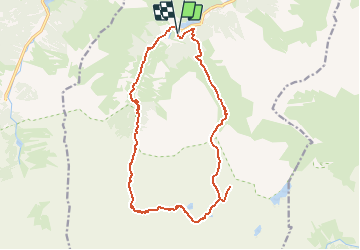
![](/images/other/stat-length.png)
![Trail Walking Estaing - Le Grand Barbat 2813m depuis le lac d'Estaing - Photo](https://media.geolcdn.com/t/1900/400/ext.pjpeg?maxdim=2&url=https%3A%2F%2Fservices.sitytrail.com%2FGeolivesWS%2FDownloadMedia.ashx%3FTrailID%3D109862%26Media%3D4849_1.jpg)
Le Grand Barbat 2813m depuis le lac d'Estaing
tracegps
User
![Length](/images/other/stat-length.png)
![Max alt](https://static1.geolcdn.com/siteimages/upload/files/1508320355ic_sort_altitude_max_24dp.png)
![Uphill gradient](https://static1.geolcdn.com/siteimages/upload/files/1508320355ic_sort_den_pos_24dp.png)
![Km-Effort](/images/other/stat-length.png)
![Min alt](https://static1.geolcdn.com/siteimages/upload/files/1508320355ic_sort_altitude_min_24dp.png)
![Downhill gradient](https://static1.geolcdn.com/siteimages/upload/files/1508320355ic_sort_den_neg_24dp.png)
![Boucle](https://static1.geolcdn.com/siteimages/upload/files/16400158638029165_repeat_loop_refresh_sync_direction_icon.png)
![Walking](https://static1.geolcdn.com/sitytour/trail-icons/101.png)
9h00
Difficulty : Very difficult
![Scan this QR Code to open this trail in the SityTrail application](https://capi.geolives.com/qq0zvz2zws4bq2lad0pu/sitytour/trails/109862/qr.png?size=200)
FREE GPS app for hiking
About
Trail Walking of 17.9 km to be discovered at Occitania, Hautespyrenees, Estaing. This trail is proposed by tracegps.
Description
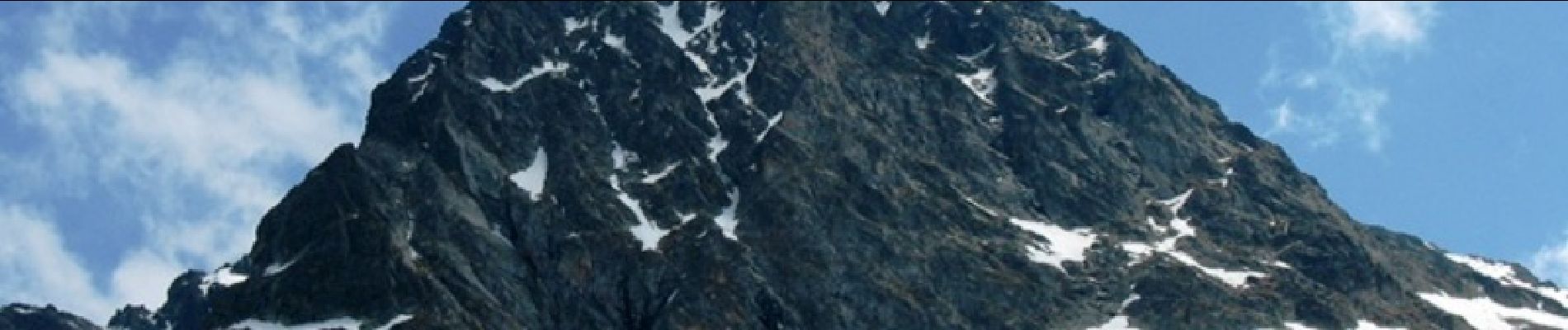
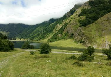
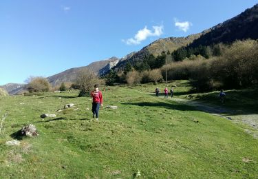
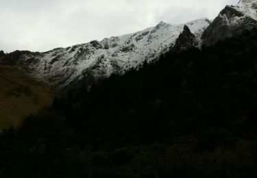
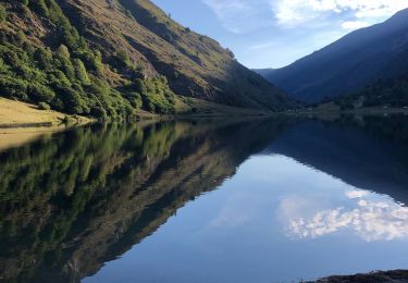
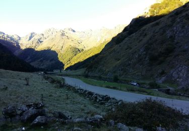
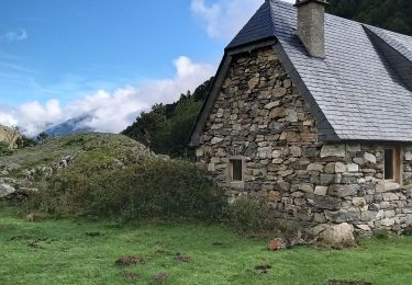
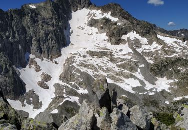
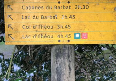
Le Grand Barbat 2813m depuis le lac d'Estaing (1162m) L'impressionnante dénivellation ne doit pas vous dissuader d'entreprendre cette ascension à la portée de tous randonneurs en bonne condition physique: la récompense est au sommet, avec un immense et splendide panorama. Le retour par les lacs situés au Nord du pic Arrouy permet un circuit très varié à travers des paysages typiquement pyrénéens. Difficulté: Dénivelée considérable. (Pour randonneurs en très bonne condition physique) D’autres indications, photos et panoramiques sur le site « Les Pyrénées vues par Mariano ». Crédit photos François Bres
Positioning
Comments
Trails nearby
![Trail Walking Estaing - Les Viellettes - Estaing - Photo](https://media.geolcdn.com/t/375/260/ext.jpg?maxdim=2&url=https%3A%2F%2Fservices.sitytrail.com%2FGeolivesWS%2FDownloadMedia.ashx%3FTrailID%3D101311%26Media%3D806_1.jpg)
![Walking Walking](https://static1.geolcdn.com/sitytour/trail-icons/101.png)
Walking
![](/images/other/stat-length.png)
![](https://static1.geolcdn.com/siteimages/upload/files/16400158638029165_repeat_loop_refresh_sync_direction_icon.png)
![Trail Walking Estaing - ESTAING RS le der de 2022 - Photo](https://media.geolcdn.com/t/375/260/0404f897-2945-4225-b4b6-dbaf65ce5d84.jpg&format=jpg&maxdim=2)
![Walking Walking](https://static1.geolcdn.com/sitytour/trail-icons/101.png)
Walking
![](/images/other/stat-length.png)
![](https://static1.geolcdn.com/siteimages/upload/files/16400158638029165_repeat_loop_refresh_sync_direction_icon.png)
![Trail Walking Estaing - ESTAING autour du lac - Photo](https://media.geolcdn.com/t/375/260/85a18d35-dba9-4c5a-81ce-af3373d459ba.jpg&format=jpg&maxdim=2)
![Walking Walking](https://static1.geolcdn.com/sitytour/trail-icons/101.png)
Walking
![](/images/other/stat-length.png)
![](https://static1.geolcdn.com/siteimages/upload/files/16400158638029165_repeat_loop_refresh_sync_direction_icon.png)
![Trail Walking Estaing - ESTAING et la cabane d'Ariousse](https://media.geolcdn.com/t/375/260/971dcf36-56bc-4869-8714-f69942a6f793.jpg&format=jpg&maxdim=2)
![Walking Walking](https://static1.geolcdn.com/sitytour/trail-icons/101.png)
Walking
![](/images/other/stat-length.png)
![](https://static1.geolcdn.com/siteimages/upload/files/16400158638029165_repeat_loop_refresh_sync_direction_icon.png)
![Trail Walking Estaing - Ruines et lac de Liantran - Photo](https://media.geolcdn.com/t/375/260/1b91bce4-1111-454c-9093-1e2ab24d6024.jpg&format=jpg&maxdim=2)
![Walking Walking](https://static1.geolcdn.com/sitytour/trail-icons/101.png)
Walking
![](/images/other/stat-length.png)
![](https://static1.geolcdn.com/siteimages/upload/files/16400158638029165_repeat_loop_refresh_sync_direction_icon.png)
![Trail Walking Estaing - ESTAING Cabane d'Ariousec en boucle G3 - Photo](https://media.geolcdn.com/t/375/260/dc2e5807-7e79-4cc0-b670-bf7996730f23.jpg&format=jpg&maxdim=2)
![Walking Walking](https://static1.geolcdn.com/sitytour/trail-icons/101.png)
Walking
![](/images/other/stat-length.png)
![](https://static1.geolcdn.com/siteimages/upload/files/16400158638029165_repeat_loop_refresh_sync_direction_icon.png)
![Trail Walking Estaing - Le lac d'Estaing - Photo](https://media.geolcdn.com/t/375/260/99541acc-32e8-489c-8cb9-fb928bd0dc43.jpg&format=jpg&maxdim=2)
![Walking Walking](https://static1.geolcdn.com/sitytour/trail-icons/101.png)
Walking
![](/images/other/stat-length.png)
![](https://static1.geolcdn.com/siteimages/upload/files/16400158638029165_repeat_loop_refresh_sync_direction_icon.png)
![Trail Walking Arrens-Marsous - pic de cristayet - Photo](https://media.geolcdn.com/t/375/260/4c1e26d5-197f-441e-9709-6adb4628c945.jpg&format=jpg&maxdim=2)
![Walking Walking](https://static1.geolcdn.com/sitytour/trail-icons/101.png)
Walking
![](/images/other/stat-length.png)
![](https://static1.geolcdn.com/siteimages/upload/files/16400158638029165_repeat_loop_refresh_sync_direction_icon.png)
![Trail Walking Estaing - Pyrénées jour 4 - Photo](https://media.geolcdn.com/t/375/260/5c6b756a-151d-456f-a813-d2eed350fb7d.jpg&format=jpg&maxdim=2)
![Walking Walking](https://static1.geolcdn.com/sitytour/trail-icons/101.png)
Walking
![](/images/other/stat-length.png)
![](https://static1.geolcdn.com/siteimages/upload/files/16400158638029165_repeat_loop_refresh_sync_direction_icon.png)