![](/images/other/stat-length.png)
![Trail Walking Pommereuil - Sentier bocager de Pommereuil - Photo](https://media.geolcdn.com/t/1900/400/ext.pjpeg?maxdim=2&url=https%3A%2F%2Fservices.sitytrail.com%2FGeolivesWS%2FDownloadMedia.ashx%3FTrailID%3D109830%26Media%3D4798_1.jpg)
Sentier bocager de Pommereuil
tracegps
User
![Length](/images/other/stat-length.png)
Length
5.8 km
![Max alt](https://static1.geolcdn.com/siteimages/upload/files/1508320355ic_sort_altitude_max_24dp.png)
Max alt
162 m
![Uphill gradient](https://static1.geolcdn.com/siteimages/upload/files/1508320355ic_sort_den_pos_24dp.png)
Uphill gradient
52 m
![Km-Effort](/images/other/stat-length.png)
Km-Effort
6.5 km
![Min alt](https://static1.geolcdn.com/siteimages/upload/files/1508320355ic_sort_altitude_min_24dp.png)
Min alt
123 m
![Downhill gradient](https://static1.geolcdn.com/siteimages/upload/files/1508320355ic_sort_den_neg_24dp.png)
Downhill gradient
52 m
![Boucle](https://static1.geolcdn.com/siteimages/upload/files/16400158638029165_repeat_loop_refresh_sync_direction_icon.png)
Boucle
Yes
Creation date :
2014-12-10 00:00:00.0
Updated on :
2014-12-10 00:00:00.0
![Walking](https://static1.geolcdn.com/sitytour/trail-icons/101.png)
1h30
Difficulty : Easy
![Scan this QR Code to open this trail in the SityTrail application](https://capi.geolives.com/qq0zvz2zws4bq2lad0pu/sitytour/trails/109830/qr.png?size=200)
FREE GPS app for hiking
About
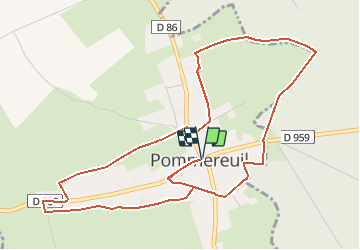
Trail Walking of 5.8 km to be discovered at Hauts-de-France, Nord, Pommereuil. This trail is proposed by tracegps.
Description
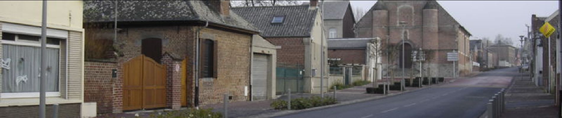
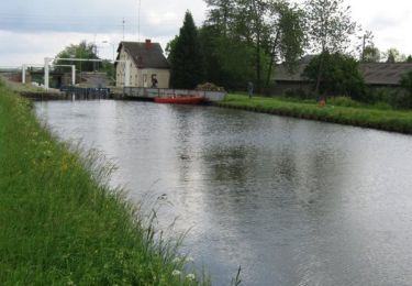
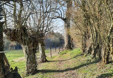
Départ de l’église de Pommereuil. Ce circuit entre Cambrésis et Avesnois emprunte chemins bocagers et forestiers ou des rues de village à l’ambiance variée. Retrouvez cette randonnée sur le site du Comité Départemental du Tourisme du Nord.
Positioning
Country:
France
Region :
Hauts-de-France
Department/Province :
Nord
Municipality :
Pommereuil
Location:
Unknown
Start:(Dec)
Start:(UTM)
542670 ; 5551341 (31U) N.
Comments
Trails nearby
![Trail Walking Ors - Sentier de bois l'Evèque - Photo](https://media.geolcdn.com/t/375/260/ext.jpg?maxdim=2&url=https%3A%2F%2Fservices.sitytrail.com%2FGeolivesWS%2FDownloadMedia.ashx%3FTrailID%3D202852%26Media%3D1c1adb39-0911-463a-9fd7-ce408a766ed5.jpg)
![Walking Walking](https://static1.geolcdn.com/sitytour/trail-icons/101.png)
Sentier de bois l'Evèque
Walking
Very easy
Ors,
Hauts-de-France,
Nord,
France
![](/images/other/stat-length.png)
6.5 km | 7.3 km-effort
Unknown
![](https://static1.geolcdn.com/siteimages/upload/files/16400158638029165_repeat_loop_refresh_sync_direction_icon.png)
Yes
![Trail Walking Bousies - Circuit « Perds-tes-Peines » (Bousies) - Photo](https://media.geolcdn.com/t/375/260/ext.jpg?maxdim=2&url=https%3A%2F%2Fservices.sitytrail.com%2FGeolivesWS%2FDownloadMedia.ashx%3FTrailID%3D110010%26Media%3D5111_3.jpg)
![Walking Walking](https://static1.geolcdn.com/sitytour/trail-icons/101.png)
Circuit « Perds-tes-Peines » (Bousies)
Walking
Easy
Bousies,
Hauts-de-France,
Nord,
France
![](/images/other/stat-length.png)
3.7 km | 4.1 km-effort
1h 0min
![](https://static1.geolcdn.com/siteimages/upload/files/16400158638029165_repeat_loop_refresh_sync_direction_icon.png)
Yes
![Trail Walking Ors - Sentier de Bois l'évêque (Ors) - Photo](https://media.geolcdn.com/t/375/260/ext.jpg?maxdim=2&url=https%3A%2F%2Fservices.sitytrail.com%2FGeolivesWS%2FDownloadMedia.ashx%3FTrailID%3D109829%26Media%3D4797_6.jpg)
![Walking Walking](https://static1.geolcdn.com/sitytour/trail-icons/101.png)
Sentier de Bois l'évêque (Ors)
Walking
Medium
Ors,
Hauts-de-France,
Nord,
France
![](/images/other/stat-length.png)
11.2 km | 12.7 km-effort
2h 49min
![](https://static1.geolcdn.com/siteimages/upload/files/16400158638029165_repeat_loop_refresh_sync_direction_icon.png)
Yes
![Trail Walking Bazuel - Bazuel - Photo](https://media.geolcdn.com/t/375/260/967bb861-2104-403e-a401-c7e9829f3080.jpg&format=jpg&maxdim=2)
![Walking Walking](https://static1.geolcdn.com/sitytour/trail-icons/101.png)
![Trail Mountain bike Fontaine-au-Bois - VTT de Fontaine au Bois - Photo](https://media.geolcdn.com/t/375/260/ext.jpg?maxdim=2&url=https%3A%2F%2Fservices.sitytrail.com%2FGeolivesWS%2FDownloadMedia.ashx%3FTrailID%3D110043%26Media%3D5149_1.jpg)
![Mountain bike Mountain bike](https://static1.geolcdn.com/sitytour/trail-icons/202.png)
VTT de Fontaine au Bois
Mountain bike
Easy
(1)
Fontaine-au-Bois,
Hauts-de-France,
Nord,
France
![](/images/other/stat-length.png)
13.5 km | 14.8 km-effort
1h 30min
![](https://static1.geolcdn.com/siteimages/upload/files/16400158638029165_repeat_loop_refresh_sync_direction_icon.png)
Yes
![Trail Bicycle tourism Le Cateau-Cambrésis - Le Cateau Cambrésis - Photo](https://media.geolcdn.com/t/375/260/ext.jpg?maxdim=2&url=https%3A%2F%2Fstatic1.geolcdn.com%2Fsiteimages%2Fupload%2Ffiles%2F1524743154velo.jpg)
![Bicycle tourism Bicycle tourism](https://static1.geolcdn.com/sitytour/trail-icons/204.png)
Le Cateau Cambrésis
Bicycle tourism
Very easy
Le Cateau-Cambrésis,
Hauts-de-France,
Nord,
France
![](/images/other/stat-length.png)
34 km | 38 km-effort
2h 6min
![](https://static1.geolcdn.com/siteimages/upload/files/16400158638029165_repeat_loop_refresh_sync_direction_icon.png)
Yes
![Trail Walking Le Cateau-Cambrésis - Le Cateau circuit Matisse sa ville et ses trésors - Photo](https://media.geolcdn.com/t/375/260/ext.jpg?maxdim=2&url=https%3A%2F%2Fstatic1.geolcdn.com%2Fsiteimages%2Fupload%2Ffiles%2F1553511878bg_sport_marche.png)
![Walking Walking](https://static1.geolcdn.com/sitytour/trail-icons/101.png)
Le Cateau circuit Matisse sa ville et ses trésors
Walking
Easy
Le Cateau-Cambrésis,
Hauts-de-France,
Nord,
France
![](/images/other/stat-length.png)
5.2 km | 6 km-effort
1h 35min
![](https://static1.geolcdn.com/siteimages/upload/files/16400158638029165_repeat_loop_refresh_sync_direction_icon.png)
Yes
![Trail Walking Fontaine-au-Bois - Fontaine 6 - Photo](https://media.geolcdn.com/t/375/260/ext.jpg?maxdim=2&url=https%3A%2F%2Fstatic1.geolcdn.com%2Fsiteimages%2Fupload%2Ffiles%2F1553511878bg_sport_marche.png)
![Walking Walking](https://static1.geolcdn.com/sitytour/trail-icons/101.png)
Fontaine 6
Walking
Medium
Fontaine-au-Bois,
Hauts-de-France,
Nord,
France
![](/images/other/stat-length.png)
10.4 km | 11.6 km-effort
2h 34min
![](https://static1.geolcdn.com/siteimages/upload/files/16400158638029165_repeat_loop_refresh_sync_direction_icon.png)
Yes
![Trail Walking Pommereuil - Pommereuil et la fôret de bois l'évêque - Photo](https://media.geolcdn.com/t/375/260/ext.jpg?maxdim=2&url=https%3A%2F%2Fstatic1.geolcdn.com%2Fsiteimages%2Fupload%2Ffiles%2F1553511878bg_sport_marche.png)
![Walking Walking](https://static1.geolcdn.com/sitytour/trail-icons/101.png)
Pommereuil et la fôret de bois l'évêque
Walking
Difficult
Pommereuil,
Hauts-de-France,
Nord,
France
![](/images/other/stat-length.png)
9 km | 10.2 km-effort
2h 55min
![](https://static1.geolcdn.com/siteimages/upload/files/16400158638029165_repeat_loop_refresh_sync_direction_icon.png)
Yes