![](/images/other/stat-length.png)
![Trail Walking Étrœungt - Sentier de Petit Bois (Etroeungt) - Photo](https://media.geolcdn.com/t/1900/400/ext.pjpeg?maxdim=2&url=https%3A%2F%2Fservices.sitytrail.com%2FGeolivesWS%2FDownloadMedia.ashx%3FTrailID%3D109799%26Media%3D4734_1.jpg)
Sentier de Petit Bois (Etroeungt)
tracegps
User
![Length](/images/other/stat-length.png)
Length
8.1 km
![Max alt](https://static1.geolcdn.com/siteimages/upload/files/1508320355ic_sort_altitude_max_24dp.png)
Max alt
195 m
![Uphill gradient](https://static1.geolcdn.com/siteimages/upload/files/1508320355ic_sort_den_pos_24dp.png)
Uphill gradient
99 m
![Km-Effort](/images/other/stat-length.png)
Km-Effort
9.5 km
![Min alt](https://static1.geolcdn.com/siteimages/upload/files/1508320355ic_sort_altitude_min_24dp.png)
Min alt
159 m
![Downhill gradient](https://static1.geolcdn.com/siteimages/upload/files/1508320355ic_sort_den_neg_24dp.png)
Downhill gradient
99 m
![Boucle](https://static1.geolcdn.com/siteimages/upload/files/16400158638029165_repeat_loop_refresh_sync_direction_icon.png)
Boucle
Yes
Creation date :
2014-12-10 00:00:00.0
Updated on :
2014-12-10 00:00:00.0
![Walking](https://static1.geolcdn.com/sitytour/trail-icons/101.png)
2h00
Difficulty : Medium
![Scan this QR Code to open this trail in the SityTrail application](https://capi.geolives.com/qq0zvz2zws4bq2lad0pu/sitytour/trails/109799/qr.png?size=200)
FREE GPS app for hiking
About
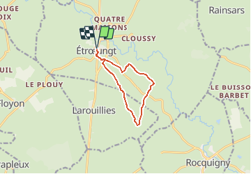
Trail Walking of 8.1 km to be discovered at Hauts-de-France, Nord, Étrœungt. This trail is proposed by tracegps.
Description
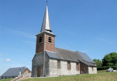
Circuit proposé par le comité départemental du tourisme du Nord et le Syndicat d’Initiative de Etroeungt. Départ de l’église d’Etroeungt. Ce circuit, offre de belles perspectives sur la vallée de l'Helpe Mineure. Retrouvez cette randonnée sur le site du Comité Départemental du Tourisme du Nord.
Positioning
Country:
France
Region :
Hauts-de-France
Department/Province :
Nord
Municipality :
Étrœungt
Location:
Unknown
Start:(Dec)
Start:(UTM)
566421 ; 5545533 (31U) N.
Comments
Trails nearby
![Trail Walking Étrœungt - Sentier du Cul de Sac (Etroeungt) - Photo](https://media.geolcdn.com/t/375/260/ext.jpg?maxdim=2&url=https%3A%2F%2Fservices.sitytrail.com%2FGeolivesWS%2FDownloadMedia.ashx%3FTrailID%3D109800%26Media%3D4735_3.jpg)
![Walking Walking](https://static1.geolcdn.com/sitytour/trail-icons/101.png)
Sentier du Cul de Sac (Etroeungt)
Walking
Medium
Étrœungt,
Hauts-de-France,
Nord,
France
![](/images/other/stat-length.png)
9 km | 10.3 km-effort
2h 15min
![](https://static1.geolcdn.com/siteimages/upload/files/16400158638029165_repeat_loop_refresh_sync_direction_icon.png)
Yes
![Trail Walking Étrœungt - Sentier du Buffle (Etroeungt) - Photo](https://media.geolcdn.com/t/375/260/ext.jpg?maxdim=2&url=https%3A%2F%2Fservices.sitytrail.com%2FGeolivesWS%2FDownloadMedia.ashx%3FTrailID%3D109798%26Media%3D4733_3.jpg)
![Walking Walking](https://static1.geolcdn.com/sitytour/trail-icons/101.png)
Sentier du Buffle (Etroeungt)
Walking
Medium
Étrœungt,
Hauts-de-France,
Nord,
France
![](/images/other/stat-length.png)
11.5 km | 13.7 km-effort
3h 0min
![](https://static1.geolcdn.com/siteimages/upload/files/16400158638029165_repeat_loop_refresh_sync_direction_icon.png)
Yes
![Trail Walking Larouillies - Larouillies - Sentier de Larouillies - Photo](https://media.geolcdn.com/t/375/260/ext.jpg?maxdim=2&url=https%3A%2F%2Fservices.sitytrail.com%2FGeolivesWS%2FDownloadMedia.ashx%3FTrailID%3D110002%26Media%3D5086_1.jpg)
![Walking Walking](https://static1.geolcdn.com/sitytour/trail-icons/101.png)
Larouillies - Sentier de Larouillies
Walking
Easy
Larouillies,
Hauts-de-France,
Nord,
France
![](/images/other/stat-length.png)
5.8 km | 6.9 km-effort
1h 30min
![](https://static1.geolcdn.com/siteimages/upload/files/16400158638029165_repeat_loop_refresh_sync_direction_icon.png)
Yes
![Trail Walking Floyon - Circuit de la vallée du Chevireuil - Floyon - Photo](https://media.geolcdn.com/t/375/260/ext.jpg?maxdim=2&url=https%3A%2F%2Fservices.sitytrail.com%2FGeolivesWS%2FDownloadMedia.ashx%3FTrailID%3D109910%26Media%3D4921_1.jpg)
![Walking Walking](https://static1.geolcdn.com/sitytour/trail-icons/101.png)
Circuit de la vallée du Chevireuil - Floyon
Walking
Medium
Floyon,
Hauts-de-France,
Nord,
France
![](/images/other/stat-length.png)
9.1 km | 10.8 km-effort
2h 15min
![](https://static1.geolcdn.com/siteimages/upload/files/16400158638029165_repeat_loop_refresh_sync_direction_icon.png)
Yes
![Trail Walking Étrœungt - randonnée etroeungt - Photo](https://media.geolcdn.com/t/375/260/ext.jpg?maxdim=2&url=https%3A%2F%2Fstatic1.geolcdn.com%2Fsiteimages%2Fupload%2Ffiles%2F1553511878bg_sport_marche.png)
![Walking Walking](https://static1.geolcdn.com/sitytour/trail-icons/101.png)
randonnée etroeungt
Walking
Medium
Étrœungt,
Hauts-de-France,
Nord,
France
![](/images/other/stat-length.png)
8.8 km | 10.1 km-effort
2h 35min
![](https://static1.geolcdn.com/siteimages/upload/files/16400158638029165_repeat_loop_refresh_sync_direction_icon.png)
Yes
![Trail Walking Étrœungt - 59.783 Etreungt - CIrcuit Buisson Moreau - Photo](https://media.geolcdn.com/t/375/260/ext.jpg?maxdim=2&url=https%3A%2F%2Fstatic1.geolcdn.com%2Fsiteimages%2Fupload%2Ffiles%2F1553511878bg_sport_marche.png)
![Walking Walking](https://static1.geolcdn.com/sitytour/trail-icons/101.png)
59.783 Etreungt - CIrcuit Buisson Moreau
Walking
Medium
Étrœungt,
Hauts-de-France,
Nord,
France
![](/images/other/stat-length.png)
18.8 km | 22 km-effort
4h 55min
![](https://static1.geolcdn.com/siteimages/upload/files/16400158638029165_repeat_loop_refresh_sync_direction_icon.png)
Yes
![Trail Walking Rainsars - rainsars - Photo](https://media.geolcdn.com/t/375/260/ext.jpg?maxdim=2&url=https%3A%2F%2Fstatic1.geolcdn.com%2Fsiteimages%2Fupload%2Ffiles%2F1553511878bg_sport_marche.png)
![Walking Walking](https://static1.geolcdn.com/sitytour/trail-icons/101.png)
![Trail Walking Larouillies - larouillies - Photo](https://media.geolcdn.com/t/375/260/ext.jpg?maxdim=2&url=https%3A%2F%2Fstatic1.geolcdn.com%2Fsiteimages%2Fupload%2Ffiles%2F1553511878bg_sport_marche.png)
![Walking Walking](https://static1.geolcdn.com/sitytour/trail-icons/101.png)
larouillies
Walking
Difficult
(1)
Larouillies,
Hauts-de-France,
Nord,
France
![](/images/other/stat-length.png)
10.9 km | 12.8 km-effort
5h 23min
![](https://static1.geolcdn.com/siteimages/upload/files/16400158638029165_repeat_loop_refresh_sync_direction_icon.png)
Yes
![Trail Walking Papleux - papleu - Photo](https://media.geolcdn.com/t/375/260/ext.jpg?maxdim=2&url=https%3A%2F%2Fstatic1.geolcdn.com%2Fsiteimages%2Fupload%2Ffiles%2F1553511878bg_sport_marche.png)
![Walking Walking](https://static1.geolcdn.com/sitytour/trail-icons/101.png)
papleu
Walking
Difficult
(1)
Papleux,
Hauts-de-France,
Aisne,
France
![](/images/other/stat-length.png)
11.1 km | 12.2 km-effort
2h 47min
![](https://static1.geolcdn.com/siteimages/upload/files/16400158638029165_repeat_loop_refresh_sync_direction_icon.png)
Yes
Chemin à ne pas prendre après les pluies