![](/images/other/stat-length.png)
![Trail Walking Villenauxe-la-Grande - Terroirs et vignes en Val de Noxe - Photo](https://media.geolcdn.com/t/1900/400/ext.pjpeg?maxdim=2&url=https%3A%2F%2Fservices.sitytrail.com%2FGeolivesWS%2FDownloadMedia.ashx%3FTrailID%3D109757%26Media%3D4584_1.jpg)
Terroirs et vignes en Val de Noxe
tracegps
User
![Length](/images/other/stat-length.png)
Length
18.3 km
![Max alt](https://static1.geolcdn.com/siteimages/upload/files/1508320355ic_sort_altitude_max_24dp.png)
Max alt
185 m
![Uphill gradient](https://static1.geolcdn.com/siteimages/upload/files/1508320355ic_sort_den_pos_24dp.png)
Uphill gradient
384 m
![Km-Effort](/images/other/stat-length.png)
Km-Effort
23 km
![Min alt](https://static1.geolcdn.com/siteimages/upload/files/1508320355ic_sort_altitude_min_24dp.png)
Min alt
76 m
![Downhill gradient](https://static1.geolcdn.com/siteimages/upload/files/1508320355ic_sort_den_neg_24dp.png)
Downhill gradient
384 m
![Boucle](https://static1.geolcdn.com/siteimages/upload/files/16400158638029165_repeat_loop_refresh_sync_direction_icon.png)
Boucle
Yes
Creation date :
2014-12-10 00:00:00.0
Updated on :
2014-12-10 00:00:00.0
![Walking](https://static1.geolcdn.com/sitytour/trail-icons/101.png)
4h15
Difficulty : Difficult
![Scan this QR Code to open this trail in the SityTrail application](https://capi.geolives.com/qq0zvz2zws4bq2lad0pu/sitytour/trails/109757/qr.png?size=200)
FREE GPS app for hiking
About
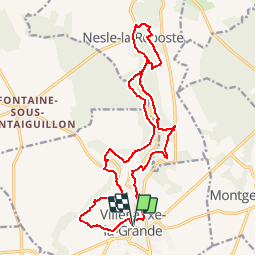
Trail Walking of 18.3 km to be discovered at Grand Est, Aube, Villenauxe-la-Grande. This trail is proposed by tracegps.
Description
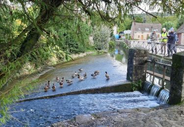
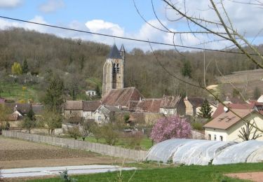
Terroirs et vignes en Val de Noxe. L’Union Sportive de Villenauxe à créé en 2005, ce sentier qui propose une grande diversité de paysages et de magnifiques panoramas sur les 17 Kms de son parcours. Départ de l'église de Villenauxe-la-Grande
Positioning
Country:
France
Region :
Grand Est
Department/Province :
Aube
Municipality :
Villenauxe-la-Grande
Location:
Unknown
Start:(Dec)
Start:(UTM)
540920 ; 5381980 (31U) N.
Comments
Trails nearby
![Trail Walking Montpothier - MONTPOTHIER, LE VILLAGE ET LES ETANGS - Photo](https://media.geolcdn.com/t/375/260/01e0c3a2-8c77-4555-836b-2b52afee3f19.jpg&format=jpg&maxdim=2)
![Walking Walking](https://static1.geolcdn.com/sitytour/trail-icons/101.png)
MONTPOTHIER, LE VILLAGE ET LES ETANGS
Walking
Medium
(1)
Montpothier,
Grand Est,
Aube,
France
![](/images/other/stat-length.png)
7.5 km | 9.1 km-effort
2h 4min
![](https://static1.geolcdn.com/siteimages/upload/files/16400158638029165_repeat_loop_refresh_sync_direction_icon.png)
Yes
![Trail Walking Montpothier - MONTPOTHIER - Photo](https://media.geolcdn.com/t/375/260/243edc4c-d5b0-427b-a5fd-d7965adec185.jpg&format=jpg&maxdim=2)
![Walking Walking](https://static1.geolcdn.com/sitytour/trail-icons/101.png)
![Trail Walking Villenauxe-la-Grande - VILLENAUXE LA GRANDE, village et Val de Noxe - Photo](https://media.geolcdn.com/t/375/260/f8542100-abf0-480b-b13c-e60ef02b60eb.jpg&format=jpg&maxdim=2)
![Walking Walking](https://static1.geolcdn.com/sitytour/trail-icons/101.png)
VILLENAUXE LA GRANDE, village et Val de Noxe
Walking
Medium
Villenauxe-la-Grande,
Grand Est,
Aube,
France
![](/images/other/stat-length.png)
8.6 km | 10.6 km-effort
2h 24min
![](https://static1.geolcdn.com/siteimages/upload/files/16400158638029165_repeat_loop_refresh_sync_direction_icon.png)
Yes
![Trail Walking Villenauxe-la-Grande - Villenauxe 3 - Photo](https://media.geolcdn.com/t/375/260/03986230-73df-4676-831b-4a2c9999dc20.jpg&format=jpg&maxdim=2)
![Walking Walking](https://static1.geolcdn.com/sitytour/trail-icons/101.png)
Villenauxe 3
Walking
Easy
Villenauxe-la-Grande,
Grand Est,
Aube,
France
![](/images/other/stat-length.png)
4 km | 5 km-effort
1h 8min
![](https://static1.geolcdn.com/siteimages/upload/files/16400158638029165_repeat_loop_refresh_sync_direction_icon.png)
Yes
![Trail Walking Villenauxe-la-Grande - VILLENAUXE LA GRANDE 1 - Photo](https://media.geolcdn.com/t/375/260/54e1d98e-470e-4350-9337-6822872ca56c.jpg&format=jpg&maxdim=2)
![Walking Walking](https://static1.geolcdn.com/sitytour/trail-icons/101.png)
VILLENAUXE LA GRANDE 1
Walking
Difficult
Villenauxe-la-Grande,
Grand Est,
Aube,
France
![](/images/other/stat-length.png)
11.3 km | 14.4 km-effort
3h 10min
![](https://static1.geolcdn.com/siteimages/upload/files/16400158638029165_repeat_loop_refresh_sync_direction_icon.png)
Yes
![Trail Walking Villenauxe-la-Grande - Terroirs et vignes en Val de Noxe - Photo](https://media.geolcdn.com/t/375/260/ext.jpg?maxdim=2&url=https%3A%2F%2Fstatic1.geolcdn.com%2Fsiteimages%2Fupload%2Ffiles%2F1553511878bg_sport_marche.png)
![Walking Walking](https://static1.geolcdn.com/sitytour/trail-icons/101.png)
Terroirs et vignes en Val de Noxe
Walking
Medium
(1)
Villenauxe-la-Grande,
Grand Est,
Aube,
France
![](/images/other/stat-length.png)
18.4 km | 24 km-effort
5h 6min
![](https://static1.geolcdn.com/siteimages/upload/files/16400158638029165_repeat_loop_refresh_sync_direction_icon.png)
Yes
![Trail Walking Villenauxe-la-Grande - Val de Noxe - Villenauxe la Grande - Photo](https://media.geolcdn.com/t/375/260/ext.jpg?maxdim=2&url=https%3A%2F%2Fservices.sitytrail.com%2FGeolivesWS%2FDownloadMedia.ashx%3FTrailID%3D317901%26Media%3D17315_5.jpg)
![Walking Walking](https://static1.geolcdn.com/sitytour/trail-icons/101.png)
Val de Noxe - Villenauxe la Grande
Walking
Medium
Villenauxe-la-Grande,
Grand Est,
Aube,
France
![](/images/other/stat-length.png)
33 km | 39 km-effort
6h 30min
![](https://static1.geolcdn.com/siteimages/upload/files/16400158638029165_repeat_loop_refresh_sync_direction_icon.png)
Yes
![Trail Walking Villenauxe-la-Grande - VILLENAUXE 2 le vignoble, les bois, la rivière Noxe, le village - Photo](https://media.geolcdn.com/t/375/260/f6fbfb1d-9c0a-4a83-9328-0b76d0d7ead5.jpg&format=jpg&maxdim=2)
![Walking Walking](https://static1.geolcdn.com/sitytour/trail-icons/101.png)
VILLENAUXE 2 le vignoble, les bois, la rivière Noxe, le village
Walking
Medium
(1)
Villenauxe-la-Grande,
Grand Est,
Aube,
France
![](/images/other/stat-length.png)
7.8 km | 10.1 km-effort
2h 18min
![](https://static1.geolcdn.com/siteimages/upload/files/16400158638029165_repeat_loop_refresh_sync_direction_icon.png)
Yes
![Trail Cycle Villenauxe-la-Grande - Vignoble de Champagne et Vallée de la Noxe - Villenauxe la Grande - Photo](https://media.geolcdn.com/t/375/260/ext.jpg?maxdim=2&url=https%3A%2F%2Fservices.sitytrail.com%2FGeolivesWS%2FDownloadMedia.ashx%3FTrailID%3D112582%26Media%3D11029_2.jpg)
![Cycle Cycle](https://static1.geolcdn.com/sitytour/trail-icons/200.png)
Vignoble de Champagne et Vallée de la Noxe - Villenauxe la Grande
Cycle
Medium
(1)
Villenauxe-la-Grande,
Grand Est,
Aube,
France
![](/images/other/stat-length.png)
66 km | 74 km-effort
3h 30min
![](https://static1.geolcdn.com/siteimages/upload/files/16400158638029165_repeat_loop_refresh_sync_direction_icon.png)
Yes