Trail Walking Saint-Martin-Vésubie - Via Alpina - D59: St-Martin-Vésubie > Belvédère - Photo

Via Alpina - D59: St-Martin-Vésubie > Belvédère

 tracegps
tracegps

User

© OpenStreetMap contributors
Length
Length
16.7 km
Max alt
Max alt
1347 m
Uphill gradient
Uphill gradient
902 m
Km-Effort
Km-Effort  
29 km
Min alt
Min alt
801 m
Downhill gradient
Downhill gradient
1084 m
Boucle
Boucle
No
Creation date :
2014-12-10 00:00:00.0
Updated on :
2014-12-10 00:00:00.0

(0 Reviews)

Walking
Walking
5h00
Difficulty : Difficult

Scan this QR Code to open this trail in the SityTrail application

FREE GPS app for hiking

Logo SityTrail SityTrail

IGN / Geographical institutes

Download SityTrail from the App Store Download SityTrail from Google Play

Logo SityTrail SityTrail World

The world is yours!

Download SityTrail from the App Store Download SityTrail from Google Play Download SityTrail on Huawei AppGallery

About

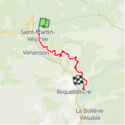
Trail Walking of 16.7 km to be discovered at Provence-Alpes-Côte d'Azur, Maritime Alps, Saint-Martin-Vésubie. This trail is proposed by tracegps.

Description

Via Alpina - D59: St-Martin-Vésubie > Belvédère. L’itinéraire sort de St-Martin-Vésubie en empruntant le GR 52A. Il chemine en pente régulière, à flanc de montagne, jusqu’à Berthemont-les-Bains, village thermal depuis le XIXe s, puis rejoint le village perché de Belvédère, point d’étape à la confluence entre les vallées de la Vésubie et de la Gordolasque. Randonnée alpine (passage équipé ou très exposé, névé, blocs). Description complète de l’étape sur Via-Alpina.org.

Elevation profile

Photos

Positioning

Country:
France
Region :
Provence-Alpes-Côte d'Azur
Department/Province :
Maritime Alps
Municipality :
Saint-Martin-Vésubie
Location:
Unknown
Start:(UTM)
360418 ; 4881268 (32T) N.

Comments

Please log in to post a review or rate the element
 

Trails nearby

Trail Walking Saint-Martin-Vésubie - Lac de Trécolpas - Photo
Walking
patsure

Walking

Medium
(2)
Saint-Martin-Vésubie, Provence-Alpes-Côte d'Azur, Maritime Alps, France
13.3 km | 20 km-effort
4h 17min
Yes
Trail Walking Saint-Martin-Vésubie - lacs bessons - Photo
Walking
REYPatrick

Walking

Very easy
(1)
Saint-Martin-Vésubie, Provence-Alpes-Côte d'Azur, Maritime Alps, France
13.1 km | 0 m-effort
7h 36min
Yes
Trail Walking Venanson - La Malouna - Photo
Walking
Benteux

Walking

Medium
(1)
Venanson, Provence-Alpes-Côte d'Azur, Maritime Alps, France
10.7 km | 17.9 km-effort
5h 20min
Yes
Trail On foot Valdeblore - Le Caïre Gros - Photo
On foot
GUIDE+

On foot

Medium
Valdeblore, Provence-Alpes-Côte d'Azur, Maritime Alps, France
9.8 km | 20 km-effort
4h 38min
Yes
Trail On foot Saint-Martin-Vésubie - Col de Cerise - Photo
On foot
GUIDE+

On foot

Medium
Saint-Martin-Vésubie, Provence-Alpes-Côte d'Azur, Maritime Alps, France
9.7 km | 23 km-effort
5h 18min
Yes
Trail On foot Venanson - Circuit du Conquet - Photo
On foot
GUIDE+

On foot

Medium
Venanson, Provence-Alpes-Côte d'Azur, Maritime Alps, France
10.2 km | 21 km-effort
4h 45min
Yes
Trail On foot Saint-Martin-Vésubie - Circuit de Trécolpas - Photo
On foot
GUIDE+

On foot

Easy
Saint-Martin-Vésubie, Provence-Alpes-Côte d'Azur, Maritime Alps, France
8.9 km | 15.8 km-effort
3h 35min
Yes
Trail Touring skiing Saint-Martin-Vésubie - Col de cerise et lac du Mercantour - Photo
Touring skiing
GUIDE
nadd73

Touring skiing

Medium
Saint-Martin-Vésubie, Provence-Alpes-Côte d'Azur, Maritime Alps, France
11.9 km | 29 km-effort
7h 39min
Yes
Trail Touring skiing Saint-Martin-Vésubie - Cime de Juisse - Photo
Touring skiing
GUIDE
nadd73

Touring skiing

Medium
Saint-Martin-Vésubie, Provence-Alpes-Côte d'Azur, Maritime Alps, France
14.1 km | 29 km-effort
6h 52min
Yes


Close
My subscriptions