Trail Walking Saint-Vallier-de-Thiey - Saint Vallier de Thiey - Photo
 domi06
domi06

User

© OpenStreetMap contributors
Length
Length
14.6 km
Max alt
Max alt
781 m
Uphill gradient
Uphill gradient
255 m
Km-Effort
Km-Effort  
18 km
Min alt
Min alt
664 m
Downhill gradient
Downhill gradient
252 m
Boucle
Boucle
Yes
Creation date :
2019-01-14 17:30:18.359
Updated on :
2019-01-14 17:30:18.359

(0 Reviews)

Walking
Walking
3h54
Difficulty : Easy

Scan this QR Code to open this trail in the SityTrail application

FREE GPS app for hiking

Logo SityTrail SityTrail

IGN / Geographical institutes

Download SityTrail from the App Store Download SityTrail from Google Play

Logo SityTrail SityTrail World

The world is yours!

Download SityTrail from the App Store Download SityTrail from Google Play Download SityTrail on Huawei AppGallery

About

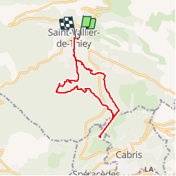
Trail Walking of 14.6 km to be discovered at Provence-Alpes-Côte d'Azur, Maritime Alps, Saint-Vallier-de-Thiey. This trail is proposed by domi06.

Description

Sommet de la croix de Cabris.
Dolmen de Verdonline
La pierre Druidique
Le castel Abram

Elevation profile

Positioning

Country:
France
Region :
Provence-Alpes-Côte d'Azur
Department/Province :
Maritime Alps
Municipality :
Saint-Vallier-de-Thiey
Location:
Unknown
Start:(UTM)
326800 ; 4840628 (32T) N.

Trails nearby

Trail Walking Caussols - Le Haut Montet 1335m, Plateau de Caussols - Photo
Walking
tracegps

Walking

Easy
(1)
Caussols, Provence-Alpes-Côte d'Azur, Maritime Alps, France
13.5 km | 18.6 km-effort
4h 0min
Yes
Trail Walking Saint-Vallier-de-Thiey - Arche de Ponadieu Source de la Pare Baou Mourine Vieux Pont  - Photo
Walking
GUIDE
jouans

Walking

Very difficult
Saint-Vallier-de-Thiey, Provence-Alpes-Côte d'Azur, Maritime Alps, France
19.2 km | 32 km-effort
7h 20min
Yes
Trail On foot Caussols - Plateau de Caussols - Photo
On foot
GUIDE+

On foot

Easy
Caussols, Provence-Alpes-Côte d'Azur, Maritime Alps, France
13.9 km | 19.1 km-effort
4h 20min
Yes
Trail On foot Escragnolles - Plateau de Briasq - Photo
On foot
GUIDE+

On foot

Medium
Escragnolles, Provence-Alpes-Côte d'Azur, Maritime Alps, France
14.1 km | 22 km-effort
4h 56min
Yes
Trail Walking Caussols - La Meute Plateau de Caussols 3 - Photo
Walking
DIDIERLESERT

Walking

Medium
(1)
Caussols, Provence-Alpes-Côte d'Azur, Maritime Alps, France
12.4 km | 17.2 km-effort
4h 0min
Yes
Trail Walking Saint-Vallier-de-Thiey - Grasse - Montagne de Thiey - Photo
Walking
GUIDE
Orcal37

Walking

Medium
Saint-Vallier-de-Thiey, Provence-Alpes-Côte d'Azur, Maritime Alps, France
14.9 km | 25 km-effort
4h 54min
Yes
Trail Walking Caussols - La Meute Plateau de Caussols - Photo
Walking
DIDIERLESERT

Walking

Medium
(1)
Caussols, Provence-Alpes-Côte d'Azur, Maritime Alps, France
14.9 km | 20 km-effort
4h 17min
Yes
Trail Walking Saint-Vallier-de-Thiey - St Vallier : Colle du  maçon doublier  - Photo
Walking
ETMU5496

Walking

Difficult
Saint-Vallier-de-Thiey, Provence-Alpes-Côte d'Azur, Maritime Alps, France
18.2 km | 29 km-effort
6h 35min
Yes
Trail Walking Saint-Vallier-de-Thiey - St Vallier de Thiey - Col de la Lèque - Chapelle St Jean - Arche Ponadieu - Photo
Walking
LtZIP

Walking

Medium
Saint-Vallier-de-Thiey, Provence-Alpes-Côte d'Azur, Maritime Alps, France
14.1 km | 21 km-effort
4h 44min
Yes


Close
My subscriptions