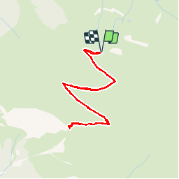
![](/images/other/stat-length.png)
![Trail Walking Luz-Saint-Sauveur - Le Pic Bergons - Photo](https://media.geolcdn.com/t/1900/400/ext.pjpeg?maxdim=2&url=https%3A%2F%2Fservices.sitytrail.com%2FGeolivesWS%2FDownloadMedia.ashx%3FTrailID%3D109617%26Media%3D4249_5.jpg)
Le Pic Bergons
tracegps
User
![Length](/images/other/stat-length.png)
![Max alt](https://static1.geolcdn.com/siteimages/upload/files/1508320355ic_sort_altitude_max_24dp.png)
![Uphill gradient](https://static1.geolcdn.com/siteimages/upload/files/1508320355ic_sort_den_pos_24dp.png)
![Km-Effort](/images/other/stat-length.png)
![Min alt](https://static1.geolcdn.com/siteimages/upload/files/1508320355ic_sort_altitude_min_24dp.png)
![Downhill gradient](https://static1.geolcdn.com/siteimages/upload/files/1508320355ic_sort_den_neg_24dp.png)
![Boucle](https://static1.geolcdn.com/siteimages/upload/files/16400158638029165_repeat_loop_refresh_sync_direction_icon.png)
![Walking](https://static1.geolcdn.com/sitytour/trail-icons/101.png)
2h10
Difficulty : Medium
![Scan this QR Code to open this trail in the SityTrail application](https://capi.geolives.com/qq0zvz2zws4bq2lad0pu/sitytour/trails/109617/qr.png?size=200)
FREE GPS app for hiking
About
Trail Walking of 4.6 km to be discovered at Occitania, Hautespyrenees, Luz-Saint-Sauveur. This trail is proposed by tracegps.
Description
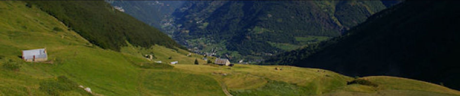
Le chemin de terre démarre à gauche une cinquantaine de mètre avant la dernière grange et remonte le Barradé, il ne tarde pas à se transformer en sentier. D'abord orienté Sud Est sur la face Sud Est du Pic Bergons, il effectue lacet Sud Ouest dans la prairie puis revient Sud Est pour déboucher sur un Col au niveau de la Cabane de Bouchirou. On remonte alors la crête Est herbeuse du Pic de Bergons (1:05). Toute la vallée du Gave de Pau est à nos pieds. Au Sud, vue grandiose sur le Cirque de Gavarnie (Les Gabietous, le Pic du Taillon, la Brêche Roland, Le Casque, Le Marboré, le Mont Perdu...), au Nord, Luz Ardiden, Argelès Gazost et le Pic de Viscos, la crête menat au Pic du Midi de Bigorre... Bref, il est rare de trouver un tel belvédère à une heure de marche! La descente s'effectue par le même chemin au milieu des fleurs, magnifique! (2:10)
Positioning
Comments
Trails nearby
![Trail On foot Esterre - SityTrail - ESTERRE Viella / Luz / Esquieze / Esterre en boucle bis - Photo](https://media.geolcdn.com/t/375/260/ext.jpg?maxdim=2&url=https%3A%2F%2Fstatic1.geolcdn.com%2Fsiteimages%2Fupload%2Ffiles%2F1545311037marcheuse_200dpi.jpg)
![On foot On foot](https://static1.geolcdn.com/sitytour/trail-icons/100.png)
On foot
![](/images/other/stat-length.png)
![](https://static1.geolcdn.com/siteimages/upload/files/16400158638029165_repeat_loop_refresh_sync_direction_icon.png)
![Trail Walking Luz-Saint-Sauveur - Pic Bergons 2068m - Photo](https://media.geolcdn.com/t/375/260/ext.jpg?maxdim=2&url=https%3A%2F%2Fservices.sitytrail.com%2FGeolivesWS%2FDownloadMedia.ashx%3FTrailID%3D110164%26Media%3D5364_1.jpg)
![Walking Walking](https://static1.geolcdn.com/sitytour/trail-icons/101.png)
Walking
![](/images/other/stat-length.png)
![](https://static1.geolcdn.com/siteimages/upload/files/16400158638029165_repeat_loop_refresh_sync_direction_icon.png)
![Trail Walking Sazos - Lac de Bastampe 2019m - Photo](https://media.geolcdn.com/t/375/260/ext.jpg?maxdim=2&url=https%3A%2F%2Fservices.sitytrail.com%2FGeolivesWS%2FDownloadMedia.ashx%3FTrailID%3D109956%26Media%3D5020_1.jpg)
![Walking Walking](https://static1.geolcdn.com/sitytour/trail-icons/101.png)
Walking
![](/images/other/stat-length.png)
![](https://static1.geolcdn.com/siteimages/upload/files/16400158638029165_repeat_loop_refresh_sync_direction_icon.png)
![Trail On foot Esterre - ESTERRE Villenave st Sauveur Luz Esterre G4](https://media.geolcdn.com/t/375/260/e504e3c2-e0f3-4d62-967c-0b87da2e39d2.jpg&format=jpg&maxdim=2)
![On foot On foot](https://static1.geolcdn.com/sitytour/trail-icons/100.png)
On foot
![](/images/other/stat-length.png)
![](https://static1.geolcdn.com/siteimages/upload/files/16400158638029165_repeat_loop_refresh_sync_direction_icon.png)
![Trail On foot Luz-Saint-Sauveur - LUZ SAINT SAUVEUR Les chemins de l agnouede bis - Photo](https://media.geolcdn.com/t/375/260/d3d34a72-f679-4f99-8e73-1144cca4ce03.jpg&format=jpg&maxdim=2)
![On foot On foot](https://static1.geolcdn.com/sitytour/trail-icons/100.png)
On foot
![](/images/other/stat-length.png)
![](https://static1.geolcdn.com/siteimages/upload/files/16400158638029165_repeat_loop_refresh_sync_direction_icon.png)
![Walking Walking](https://static1.geolcdn.com/sitytour/trail-icons/101.png)
Walking
![](/images/other/stat-length.png)
![](https://static1.geolcdn.com/siteimages/upload/files/16400158638029165_repeat_loop_refresh_sync_direction_icon.png)
![Trail Walking Esterre - ESTERRE et sa banlieue G4 fait le 15 02 2021 - Photo](https://media.geolcdn.com/t/375/260/5aacff5c-0353-49c3-8228-86537c26a1e8.jpg&format=jpg&maxdim=2)
![Walking Walking](https://static1.geolcdn.com/sitytour/trail-icons/101.png)
Walking
![](/images/other/stat-length.png)
![](https://static1.geolcdn.com/siteimages/upload/files/16400158638029165_repeat_loop_refresh_sync_direction_icon.png)
![Trail On foot Sassis - SASSIS les chemins de l agnouede fait G3 le 28/02/2020 - Photo](https://media.geolcdn.com/t/375/260/6f6c3b1a-9cea-4f2c-a1da-77e7c1b7b423.jpg&format=jpg&maxdim=2)
![On foot On foot](https://static1.geolcdn.com/sitytour/trail-icons/100.png)
On foot
![](/images/other/stat-length.png)
![](https://static1.geolcdn.com/siteimages/upload/files/16400158638029165_repeat_loop_refresh_sync_direction_icon.png)
![Trail Walking Sazos - SityTrail - Circuit des Trois villages G3 - Photo](https://media.geolcdn.com/t/375/260/ext.jpg?maxdim=2&url=https%3A%2F%2Fstatic1.geolcdn.com%2Fsiteimages%2Fupload%2Ffiles%2F1553511878bg_sport_marche.png)
![Walking Walking](https://static1.geolcdn.com/sitytour/trail-icons/101.png)
Walking
![](/images/other/stat-length.png)
![](https://static1.geolcdn.com/siteimages/upload/files/16400158638029165_repeat_loop_refresh_sync_direction_icon.png)
montée intense mais superbe spectacle
gabarnie